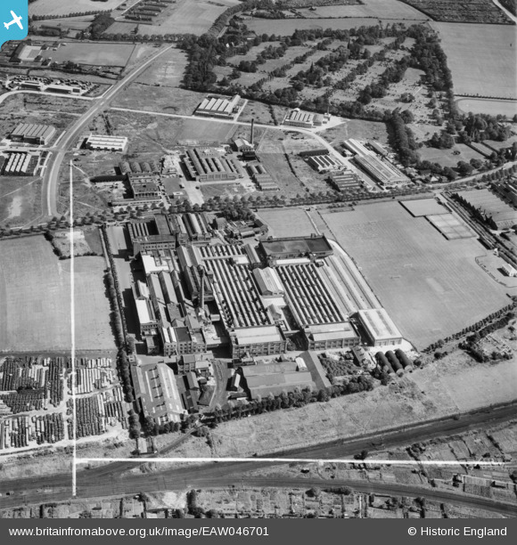
EAW046701 ENGLAND (1952). The Jacob's Bakery Ltd Biscuit Factory on Long Lane looking towards Everton Cemetery, Liverpool, 1952. This image was marked by Aerofilms Ltd for photo editing.
© Copyright OpenStreetMap contributors and licensed by the OpenStreetMap Foundation. 2026. Cartography is licensed as CC BY-SA.
Nearby Images (23)
Details
| Title | [EAW046701] The Jacob's Bakery Ltd Biscuit Factory on Long Lane looking towards Everton Cemetery, Liverpool, 1952. This image was marked by Aerofilms Ltd for photo editing. |
| Reference | EAW046701 |
| Date | 7-September-1952 |
| Link | |
| Place name | LIVERPOOL |
| Parish | |
| District | |
| Country | ENGLAND |
| Easting / Northing | 337037, 396085 |
| Longitude / Latitude | -2.9483585448824, 53.457494544085 |
| National Grid Reference | SJ370961 |
Pins
Be the first to add a comment to this image!


![[EAW046701] The Jacob's Bakery Ltd Biscuit Factory on Long Lane looking towards Everton Cemetery, Liverpool, 1952. This image was marked by Aerofilms Ltd for photo editing.](http://britainfromabove.org.uk/sites/all/libraries/aerofilms-images/public/100x100/EAW/046/EAW046701.jpg)
![[EPR000616] Jacob and Co Biscuit Factory, Liverpool, 1935](http://britainfromabove.org.uk/sites/all/libraries/aerofilms-images/public/100x100/EPR/000/EPR000616.jpg)
![[EPW042684] The Jacob's Bakery Ltd Biscuit Factory, Liverpool, 1933](http://britainfromabove.org.uk/sites/all/libraries/aerofilms-images/public/100x100/EPW/042/EPW042684.jpg)
![[EAW046695] The Jacob's Bakery Ltd Biscuit Factory on Long Lane, Liverpool, 1952. This image was marked by Aerofilms Ltd for photo editing.](http://britainfromabove.org.uk/sites/all/libraries/aerofilms-images/public/100x100/EAW/046/EAW046695.jpg)
![[EAW046697] The Jacob's Bakery Ltd Biscuit Factory on Long Lane, Liverpool, 1952](http://britainfromabove.org.uk/sites/all/libraries/aerofilms-images/public/100x100/EAW/046/EAW046697.jpg)
![[EPW018935] Jacob's Biscuit Factory, Walton, 1927](http://britainfromabove.org.uk/sites/all/libraries/aerofilms-images/public/100x100/EPW/018/EPW018935.jpg)
![[EAW046702] The Jacob's Bakery Ltd Biscuit Factory on Long Lane and environs, Liverpool, 1952. This image was marked by Aerofilms Ltd for photo editing.](http://britainfromabove.org.uk/sites/all/libraries/aerofilms-images/public/100x100/EAW/046/EAW046702.jpg)
![[EAW046699] The Jacob's Bakery Ltd Biscuit Factory on Long Lane and environs, Liverpool, 1952. This image was marked by Aerofilms Ltd for photo editing.](http://britainfromabove.org.uk/sites/all/libraries/aerofilms-images/public/100x100/EAW/046/EAW046699.jpg)
![[EAW046696] The Jacob's Bakery Ltd Biscuit Factory on Long Lane, Liverpool, 1952. This image was marked by Aerofilms Ltd for photo editing.](http://britainfromabove.org.uk/sites/all/libraries/aerofilms-images/public/100x100/EAW/046/EAW046696.jpg)
![[EAW046694] The Jacob's Bakery Ltd Biscuit Factory on Long Lane and environs, Liverpool, 1952. This image was marked by Aerofilms Ltd for photo editing.](http://britainfromabove.org.uk/sites/all/libraries/aerofilms-images/public/100x100/EAW/046/EAW046694.jpg)
![[EAW046698] The Jacob's Bakery Ltd Biscuit Factory on Long Lane and environs, Liverpool, 1952. This image was marked by Aerofilms Ltd for photo editing.](http://britainfromabove.org.uk/sites/all/libraries/aerofilms-images/public/100x100/EAW/046/EAW046698.jpg)
![[EPW042685] The Jacob's Bakery Ltd Biscuit Factory and the Hartley's Jam Factory, Liverpool, 1933](http://britainfromabove.org.uk/sites/all/libraries/aerofilms-images/public/100x100/EPW/042/EPW042685.jpg)
![[EAW046705] The Jacob's Bakery Ltd Biscuit Factory on Long Lane and environs, Liverpool, 1952. This image was marked by Aerofilms Ltd for photo editing.](http://britainfromabove.org.uk/sites/all/libraries/aerofilms-images/public/100x100/EAW/046/EAW046705.jpg)
![[EAW004624] The site of the Liver Industrial Estate and environs, Walton, from the north-west, 1947. This image was marked by Aerofilms Ltd for photo editing.](http://britainfromabove.org.uk/sites/all/libraries/aerofilms-images/public/100x100/EAW/004/EAW004624.jpg)
![[EPW042682] The Jacob's Bakery Ltd Biscuit Factory, Liverpool, 1933](http://britainfromabove.org.uk/sites/all/libraries/aerofilms-images/public/100x100/EPW/042/EPW042682.jpg)
![[EAW046706] The Jacob's Bakery Ltd Biscuit Factory on Long Lane and environs, Liverpool, 1952. This image was marked by Aerofilms Ltd for photo editing.](http://britainfromabove.org.uk/sites/all/libraries/aerofilms-images/public/100x100/EAW/046/EAW046706.jpg)
![[EAW046704] The Jacob's Bakery Ltd Biscuit Factory on Long Lane, Liverpool, 1952. This image was marked by Aerofilms Ltd for photo editing.](http://britainfromabove.org.uk/sites/all/libraries/aerofilms-images/public/100x100/EAW/046/EAW046704.jpg)
![[EPW042683] The Jacob's Bakery Ltd Biscuit Factory and the Hartley's Jam Factory, Liverpool, 1933](http://britainfromabove.org.uk/sites/all/libraries/aerofilms-images/public/100x100/EPW/042/EPW042683.jpg)
![[EAW046700] The Jacob's Bakery Ltd Biscuit Factory on Long Lane looking towards Everton Cemetery, Liverpool, 1952. This image was marked by Aerofilms Ltd for photo editing.](http://britainfromabove.org.uk/sites/all/libraries/aerofilms-images/public/100x100/EAW/046/EAW046700.jpg)
![[EAW046703] The Jacob's Bakery Ltd Biscuit Factory on Long Lane and environs, Liverpool, 1952](http://britainfromabove.org.uk/sites/all/libraries/aerofilms-images/public/100x100/EAW/046/EAW046703.jpg)
![[EAW005650] The Hartley's Jam Works, the Jacob's Biscuit Factory and Everton Cemetery, Liverpool, 1947. This image was marked by Aerofilms Ltd for photo editing.](http://britainfromabove.org.uk/sites/all/libraries/aerofilms-images/public/100x100/EAW/005/EAW005650.jpg)
![[EAW004622] Long Lane, Everton Cemetery and environs, Fazakerley, 1947](http://britainfromabove.org.uk/sites/all/libraries/aerofilms-images/public/100x100/EAW/004/EAW004622.jpg)
![[EAW004626] Hartley's Village, the site of the Liver Industrial Estate and environs, Walton, from the north-west, 1947](http://britainfromabove.org.uk/sites/all/libraries/aerofilms-images/public/100x100/EAW/004/EAW004626.jpg)