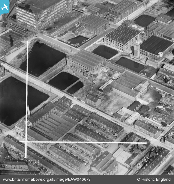
EAW046673 ENGLAND (1952). Mills, reservoirs and rows of terraced houses around Emlyn Street and Thynne Street, Farnworth, 1952. This image was marked by Aerofilms Ltd for photo editing.
© Copyright OpenStreetMap contributors and licensed by the OpenStreetMap Foundation. 2026. Cartography is licensed as CC BY-SA.
Nearby Images (27)
Details
| Title | [EAW046673] Mills, reservoirs and rows of terraced houses around Emlyn Street and Thynne Street, Farnworth, 1952. This image was marked by Aerofilms Ltd for photo editing. |
| Reference | EAW046673 |
| Date | 7-September-1952 |
| Link | |
| Place name | FARNWORTH |
| Parish | |
| District | |
| Country | ENGLAND |
| Easting / Northing | 373278, 406332 |
| Longitude / Latitude | -2.4033893711231, 53.552692789591 |
| National Grid Reference | SD733063 |
Pins
Be the first to add a comment to this image!


![[EAW046673] Mills, reservoirs and rows of terraced houses around Emlyn Street and Thynne Street, Farnworth, 1952. This image was marked by Aerofilms Ltd for photo editing.](http://britainfromabove.org.uk/sites/all/libraries/aerofilms-images/public/100x100/EAW/046/EAW046673.jpg)
![[EAW046680] Mills and reservoirs around Gower Street and Emlyn Street, Farnworth, 1952. This image was marked by Aerofilms Ltd for photo editing.](http://britainfromabove.org.uk/sites/all/libraries/aerofilms-images/public/100x100/EAW/046/EAW046680.jpg)
![[EAW046682] Mills, reservoirs and rows of terraced houses around Gower Street and Emlyn Street, Farnworth, 1952. This image was marked by Aerofilms Ltd for photo editing.](http://britainfromabove.org.uk/sites/all/libraries/aerofilms-images/public/100x100/EAW/046/EAW046682.jpg)
![[EAW046677] Mills, reservoirs and rows of terraced houses around Gower Street and Emlyn Street, Farnworth, 1952. This image was marked by Aerofilms Ltd for photo editing.](http://britainfromabove.org.uk/sites/all/libraries/aerofilms-images/public/100x100/EAW/046/EAW046677.jpg)
![[EAW046676] Mills, reservoirs and rows of terraced houses around Gower Street and Emlyn Street, Farnworth, 1952. This image was marked by Aerofilms Ltd for photo editing.](http://britainfromabove.org.uk/sites/all/libraries/aerofilms-images/public/100x100/EAW/046/EAW046676.jpg)
![[EAW046681] Mills, reservoirs and rows of terraced houses around Gower Street and Emlyn Street, Farnworth, 1952. This image was marked by Aerofilms Ltd for photo editing.](http://britainfromabove.org.uk/sites/all/libraries/aerofilms-images/public/100x100/EAW/046/EAW046681.jpg)
![[EAW046674] Mills and reservoirs around Gower Street, Emlyn Street and Thynne Street, Farnworth, 1952. This image was marked by Aerofilms Ltd for photo editing.](http://britainfromabove.org.uk/sites/all/libraries/aerofilms-images/public/100x100/EAW/046/EAW046674.jpg)
![[EAW046918] Farnworth Engineering Co Ltd Works on Emlyn Street and surrounding mills, Farnworth, 1952. This image was marked by Aerofilms Ltd for photo editing.](http://britainfromabove.org.uk/sites/all/libraries/aerofilms-images/public/100x100/EAW/046/EAW046918.jpg)
![[EAW046920] Farnworth Engineering Co Ltd Works on Emlyn Street and surrounding mills, Farnworth, 1952. This image was marked by Aerofilms Ltd for photo editing.](http://britainfromabove.org.uk/sites/all/libraries/aerofilms-images/public/100x100/EAW/046/EAW046920.jpg)
![[EAW046683] Mills and reservoirs around Gower Street and Emlyn Street, Farnworth, 1952. This image was marked by Aerofilms Ltd for photo editing.](http://britainfromabove.org.uk/sites/all/libraries/aerofilms-images/public/100x100/EAW/046/EAW046683.jpg)
![[EAW046678] Mills, reservoirs and rows of terraced houses around Gower Street and Emlyn Street, Farnworth, 1952. This image was marked by Aerofilms Ltd for photo editing.](http://britainfromabove.org.uk/sites/all/libraries/aerofilms-images/public/100x100/EAW/046/EAW046678.jpg)
![[EAW046915] Farnworth Engineering Co Ltd Works on Emlyn Street and surrounding mills, Farnworth, 1952. This image was marked by Aerofilms Ltd for photo editing.](http://britainfromabove.org.uk/sites/all/libraries/aerofilms-images/public/100x100/EAW/046/EAW046915.jpg)
![[EAW046916] Farnworth Engineering Co Ltd Works on Emlyn Street and surrounding mills, Farnworth, 1952. This image was marked by Aerofilms Ltd for photo editing.](http://britainfromabove.org.uk/sites/all/libraries/aerofilms-images/public/100x100/EAW/046/EAW046916.jpg)
![[EAW046921] Farnworth Engineering Co Ltd Works on Emlyn Street and surrounding mills, Farnworth, 1952. This image was marked by Aerofilms Ltd for photo editing.](http://britainfromabove.org.uk/sites/all/libraries/aerofilms-images/public/100x100/EAW/046/EAW046921.jpg)
![[EAW046917] Farnworth Engineering Co Ltd Works on Emlyn Street and surrounding mills, Farnworth, 1952. This image was marked by Aerofilms Ltd for photo editing.](http://britainfromabove.org.uk/sites/all/libraries/aerofilms-images/public/100x100/EAW/046/EAW046917.jpg)
![[EAW046679] Mills and reservoirs around Gower Street, Emlyn Street and Thynne Street, Farnworth, 1952. This image was marked by Aerofilms Ltd for photo editing.](http://britainfromabove.org.uk/sites/all/libraries/aerofilms-images/public/100x100/EAW/046/EAW046679.jpg)
![[EAW046922] Farnworth Engineering Co Ltd Works on Emlyn Street and surrounding mills, Farnworth, 1952. This image was marked by Aerofilms Ltd for photo editing.](http://britainfromabove.org.uk/sites/all/libraries/aerofilms-images/public/100x100/EAW/046/EAW046922.jpg)
![[EAW046919] Farnworth Engineering Co Ltd Works on Emlyn Street and surrounding mills, Farnworth, 1952. This image was marked by Aerofilms Ltd for photo editing.](http://britainfromabove.org.uk/sites/all/libraries/aerofilms-images/public/100x100/EAW/046/EAW046919.jpg)
![[EAW046914] Farnworth Engineering Co Ltd Works on Emlyn Street and surrounding mills, Farnworth, 1952. This image was marked by Aerofilms Ltd for photo editing.](http://britainfromabove.org.uk/sites/all/libraries/aerofilms-images/public/100x100/EAW/046/EAW046914.jpg)
![[EAW046675] Mills, reservoirs and rows of terraced houses around Gower Street, Emlyn Street and Thynne Street, Farnworth, 1952. This image was marked by Aerofilms Ltd for photo editing.](http://britainfromabove.org.uk/sites/all/libraries/aerofilms-images/public/100x100/EAW/046/EAW046675.jpg)
![[EPW042574] Cotton Mills off Thynne Street including Bolton Textile Mill No. 2 and Phethean's Cotton Mill, Farnworth, 1933](http://britainfromabove.org.uk/sites/all/libraries/aerofilms-images/public/100x100/EPW/042/EPW042574.jpg)
![[EPW042569] Cotton Mills off Cawdor Street including Bolton Textile Mills No. 1 and 2 and Phethean's Cotton Mill, Farnworth, 1933](http://britainfromabove.org.uk/sites/all/libraries/aerofilms-images/public/100x100/EPW/042/EPW042569.jpg)
![[EPW042571] Cotton Mills off Cawdor Street including Bolton Textile Mills No. 1 and 2 and Phethean's Cotton Mill, Farnworth, 1933](http://britainfromabove.org.uk/sites/all/libraries/aerofilms-images/public/100x100/EPW/042/EPW042571.jpg)
![[EPW042572] Cotton Mills off Cawdor Street including Bolton Textile Mills No. 1 and 2 and Phethean's Cotton Mill, Farnworth, 1933](http://britainfromabove.org.uk/sites/all/libraries/aerofilms-images/public/100x100/EPW/042/EPW042572.jpg)
![[EPW042575] Cotton Mills off Cawdor Street including Bolton Textile Mills No. 1 and 2 and Phethean's Cotton Mill, Farnworth, 1933](http://britainfromabove.org.uk/sites/all/libraries/aerofilms-images/public/100x100/EPW/042/EPW042575.jpg)
![[EPW042570] Cotton Mills off Cawdor Street including Phethean's Cotton Mill, Farnworth, 1933](http://britainfromabove.org.uk/sites/all/libraries/aerofilms-images/public/100x100/EPW/042/EPW042570.jpg)
![[EPW042573] Cotton Mills off Cawdor Street including Bolton Textile Mills No. 1 and 2 and Phethean's Cotton Mill, Farnworth, 1933](http://britainfromabove.org.uk/sites/all/libraries/aerofilms-images/public/100x100/EPW/042/EPW042573.jpg)