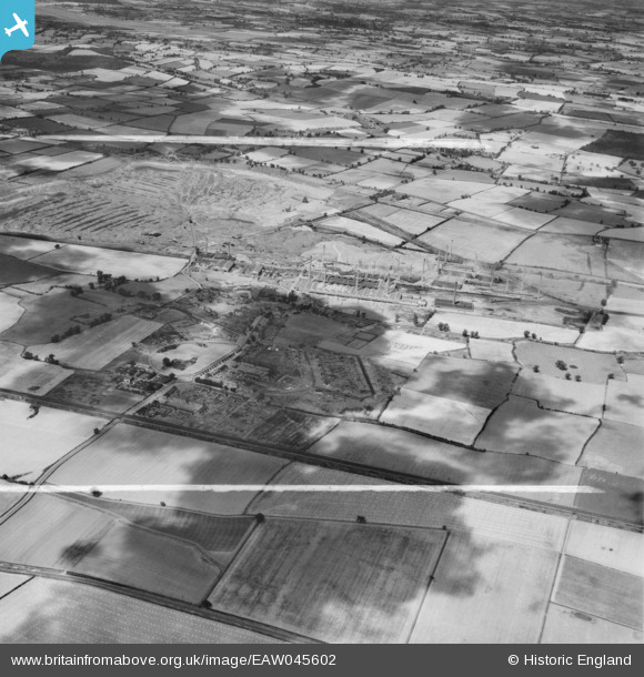
EAW045602 ENGLAND (1952). The Stewartby Brick Works and environs, Stewartby, 1952. This image was marked by Aerofilms Ltd for photo editing.
© Copyright OpenStreetMap contributors and licensed by the OpenStreetMap Foundation. 2026. Cartography is licensed as CC BY-SA.
Nearby Images (24)
Details
| Title | [EAW045602] The Stewartby Brick Works and environs, Stewartby, 1952. This image was marked by Aerofilms Ltd for photo editing. |
| Reference | EAW045602 |
| Date | 31-July-1952 |
| Link | |
| Place name | STEWARTBY |
| Parish | STEWARTBY |
| District | |
| Country | ENGLAND |
| Easting / Northing | 502033, 242474 |
| Longitude / Latitude | -0.51119995788825, 52.070805406887 |
| National Grid Reference | TL020425 |
Pins
Be the first to add a comment to this image!


![[EAW045602] The Stewartby Brick Works and environs, Stewartby, 1952. This image was marked by Aerofilms Ltd for photo editing.](http://britainfromabove.org.uk/sites/all/libraries/aerofilms-images/public/100x100/EAW/045/EAW045602.jpg)
![[EAW045603] The Stewartby Brick Works and environs, Stewartby, 1952. This image was marked by Aerofilms Ltd for photo editing.](http://britainfromabove.org.uk/sites/all/libraries/aerofilms-images/public/100x100/EAW/045/EAW045603.jpg)
![[EAW045604] The Stewartby Brick Works and environs, Stewartby, 1952. This image was marked by Aerofilms Ltd for photo editing.](http://britainfromabove.org.uk/sites/all/libraries/aerofilms-images/public/100x100/EAW/045/EAW045604.jpg)
![[EAW045822] The village and Stewartby Brick Works, Stewartby, 1952](http://britainfromabove.org.uk/sites/all/libraries/aerofilms-images/public/100x100/EAW/045/EAW045822.jpg)
![[EAW011277] The London Brick Company Stewartby Brickworks and environs, Stewartby, 1947](http://britainfromabove.org.uk/sites/all/libraries/aerofilms-images/public/100x100/EAW/011/EAW011277.jpg)
![[EAW011276] The London Brick Company Stewartby Brickworks and environs, Stewartby, 1947](http://britainfromabove.org.uk/sites/all/libraries/aerofilms-images/public/100x100/EAW/011/EAW011276.jpg)
![[EPW049653] Stewartby Way and environs, Stewartby, 1936](http://britainfromabove.org.uk/sites/all/libraries/aerofilms-images/public/100x100/EPW/049/EPW049653.jpg)
![[EAW045823] The village and Stewartby Brick Works, Stewartby, 1952. This image was marked by Aerofilms Ltd for photo editing.](http://britainfromabove.org.uk/sites/all/libraries/aerofilms-images/public/100x100/EAW/045/EAW045823.jpg)
![[EPW049654] Pillinge Brick Works and the village, Stewartby, 1936](http://britainfromabove.org.uk/sites/all/libraries/aerofilms-images/public/100x100/EPW/049/EPW049654.jpg)
![[EPW049657] Pillinge Brick Works and the village, Stewartby, 1936](http://britainfromabove.org.uk/sites/all/libraries/aerofilms-images/public/100x100/EPW/049/EPW049657.jpg)
![[EPW049658] The village, Stewartby, 1936](http://britainfromabove.org.uk/sites/all/libraries/aerofilms-images/public/100x100/EPW/049/EPW049658.jpg)
![[EAW045824] The village and Stewartby Brick Works, Stewartby, 1952. This image was marked by Aerofilms Ltd for photo editing.](http://britainfromabove.org.uk/sites/all/libraries/aerofilms-images/public/100x100/EAW/045/EAW045824.jpg)
![[EAW045821] The village and Stewartby Brick Works, Stewartby, 1952. This image was marked by Aerofilms Ltd for photo editing.](http://britainfromabove.org.uk/sites/all/libraries/aerofilms-images/public/100x100/EAW/045/EAW045821.jpg)
![[EPW026694] Wooton Pillinge, Stewartby, 1929](http://britainfromabove.org.uk/sites/all/libraries/aerofilms-images/public/100x100/EPW/026/EPW026694.jpg)
![[EPW049659] The village, Stewartby, 1936](http://britainfromabove.org.uk/sites/all/libraries/aerofilms-images/public/100x100/EPW/049/EPW049659.jpg)
![[EPW033890] Wootton Pillinge and Pillinge Brickworks, Stewartby, from the south-east, 1930](http://britainfromabove.org.uk/sites/all/libraries/aerofilms-images/public/100x100/EPW/033/EPW033890.jpg)
![[EAW045820] The Stewartby Brick Works, Stewartby, 1952. This image was marked by Aerofilms Ltd for photo editing.](http://britainfromabove.org.uk/sites/all/libraries/aerofilms-images/public/100x100/EAW/045/EAW045820.jpg)
![[EPW026697] Wooton Pillinge, Stewartby, 1929](http://britainfromabove.org.uk/sites/all/libraries/aerofilms-images/public/100x100/EPW/026/EPW026697.jpg)
![[EPW049661] The village, Stewartby, 1936](http://britainfromabove.org.uk/sites/all/libraries/aerofilms-images/public/100x100/EPW/049/EPW049661.jpg)
![[EPW026698] Wooton Pillinge, Stewartby, 1929](http://britainfromabove.org.uk/sites/all/libraries/aerofilms-images/public/100x100/EPW/026/EPW026698.jpg)
![[EPW049651] The village, Stewartby, 1936](http://britainfromabove.org.uk/sites/all/libraries/aerofilms-images/public/100x100/EPW/049/EPW049651.jpg)
![[EAW045600] The Stewartby Brick Works and environs, Stewartby, 1952. This image was marked by Aerofilms Ltd for photo editing.](http://britainfromabove.org.uk/sites/all/libraries/aerofilms-images/public/100x100/EAW/045/EAW045600.jpg)
![[EPW054973] The London Brick Co Works, Stewartby, 1937](http://britainfromabove.org.uk/sites/all/libraries/aerofilms-images/public/100x100/EPW/054/EPW054973.jpg)
![[EAW045815] The Stewartby Brick Works, Stewartby, 1952. This image was marked by Aerofilms Ltd for photo editing.](http://britainfromabove.org.uk/sites/all/libraries/aerofilms-images/public/100x100/EAW/045/EAW045815.jpg)