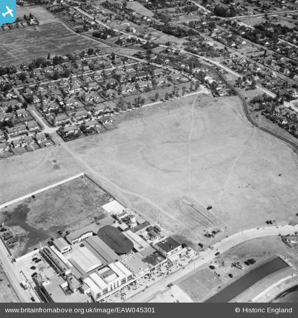
EAW045301 ENGLAND (1952). The Casino and housing around Atherstone Road and Labworth Road, Canvey Island, 1952
© Copyright OpenStreetMap contributors and licensed by the OpenStreetMap Foundation. 2026. Cartography is licensed as CC BY-SA.
Nearby Images (17)
Details
| Title | [EAW045301] The Casino and housing around Atherstone Road and Labworth Road, Canvey Island, 1952 |
| Reference | EAW045301 |
| Date | 2-August-1952 |
| Link | |
| Place name | CANVEY ISLAND |
| Parish | CANVEY ISLAND |
| District | |
| Country | ENGLAND |
| Easting / Northing | 580345, 182690 |
| Longitude / Latitude | 0.59939040909316, 51.513824092677 |
| National Grid Reference | TQ803827 |
Pins
Be the first to add a comment to this image!


![[EAW045301] The Casino and housing around Atherstone Road and Labworth Road, Canvey Island, 1952](http://britainfromabove.org.uk/sites/all/libraries/aerofilms-images/public/100x100/EAW/045/EAW045301.jpg)
![[EAW045302] Housing around Atherstone Road and Labworth Lane, Canvey Island, 1952](http://britainfromabove.org.uk/sites/all/libraries/aerofilms-images/public/100x100/EAW/045/EAW045302.jpg)
![[EAW045329] Housing around May Avenue and Labworth Lane, Canvey Island, 1952](http://britainfromabove.org.uk/sites/all/libraries/aerofilms-images/public/100x100/EAW/045/EAW045329.jpg)
![[EAW045327] The Casino, Hotel Monico and housing around Labworth Lane, Canvey Island, 1952](http://britainfromabove.org.uk/sites/all/libraries/aerofilms-images/public/100x100/EAW/045/EAW045327.jpg)
![[EAW048235] Flooded housing around Furtherwick Road and St George's Field, Canvey Island, from the south-east, 1953](http://britainfromabove.org.uk/sites/all/libraries/aerofilms-images/public/100x100/EAW/048/EAW048235.jpg)
![[EAW051058] Eastern Esplanade, Hotel Monico and adjacent casino and environs, Canvey Island, 1953](http://britainfromabove.org.uk/sites/all/libraries/aerofilms-images/public/100x100/EAW/051/EAW051058.jpg)
![[EAW051057] Eastern Esplanade and environs, Canvey Island, 1953](http://britainfromabove.org.uk/sites/all/libraries/aerofilms-images/public/100x100/EAW/051/EAW051057.jpg)
![[EAW045300] Housing around May Avenue, Canvey Island, 1952](http://britainfromabove.org.uk/sites/all/libraries/aerofilms-images/public/100x100/EAW/045/EAW045300.jpg)
![[EAW026917] The Casino and the surrounding residential area, Canvey Island, 1949](http://britainfromabove.org.uk/sites/all/libraries/aerofilms-images/public/100x100/EAW/026/EAW026917.jpg)
![[EAW026918] Eastern Esplanade, May Avenue and the surrounding residential area, Canvey Island, 1949](http://britainfromabove.org.uk/sites/all/libraries/aerofilms-images/public/100x100/EAW/026/EAW026918.jpg)
![[EAW051012] Eastern Esplanade, Hotel Monico and environs, Canvey Island, 1953](http://britainfromabove.org.uk/sites/all/libraries/aerofilms-images/public/100x100/EAW/051/EAW051012.jpg)
![[EAW045328] Housing around May Avenue, Canvey Island, 1952](http://britainfromabove.org.uk/sites/all/libraries/aerofilms-images/public/100x100/EAW/045/EAW045328.jpg)
![[EAW051050] Eastern Esplanade and environs to the east of Hotel Monico, Canvey Island, 1953](http://britainfromabove.org.uk/sites/all/libraries/aerofilms-images/public/100x100/EAW/051/EAW051050.jpg)
![[EAW051011] Eastern Esplanade and the Paddling Pool, Canvey Island, 1953](http://britainfromabove.org.uk/sites/all/libraries/aerofilms-images/public/100x100/EAW/051/EAW051011.jpg)
![[EAW051049] Eastern Esplanade, May Avenue and environs, Canvey Island, 1953](http://britainfromabove.org.uk/sites/all/libraries/aerofilms-images/public/100x100/EAW/051/EAW051049.jpg)
![[EAW045326] Cleveland Road by Hotel Monico and housing around Furtherwick Road, Canvey Island, 1952](http://britainfromabove.org.uk/sites/all/libraries/aerofilms-images/public/100x100/EAW/045/EAW045326.jpg)
![[EAW045303] Housing around Furtherwick Road, Canvey Island, 1952](http://britainfromabove.org.uk/sites/all/libraries/aerofilms-images/public/100x100/EAW/045/EAW045303.jpg)