
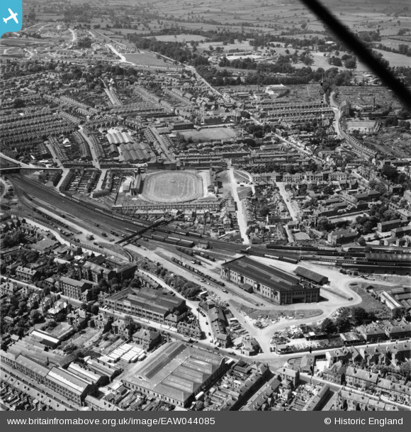
EAW044085 ENGLAND (1952). The Greyhound Stadium, Goods Depot and environs, Derby, 1952
© Copyright OpenStreetMap contributors and licensed by the OpenStreetMap Foundation. 2026. Cartography is licensed as CC BY-SA.
Nearby Images (6)
EAW044085

EAW004670

EAW004668

EAW004667

EAW004671

EAW044083

Details
| Title | [EAW044085] The Greyhound Stadium, Goods Depot and environs, Derby, 1952 |
| Reference | EAW044085 |
| Date | 10-June-1952 |
| Link | |
| Place name | DERBY |
| Parish | |
| District | |
| Country | ENGLAND |
| Easting / Northing | 434357, 336294 |
| Longitude / Latitude | -1.4889141774186, 52.922642313102 |
| National Grid Reference | SK344363 |
Pins

60's Soul |
Thursday 16th of April 2026 09:09:41 AM | |
|
60's Soul |
Friday 30th of January 2026 05:51:51 PM | |
|
60's Soul |
Friday 30th of January 2026 05:50:12 PM | |
|
60's Soul |
Friday 30th of January 2026 05:47:33 PM | |
|
60's Soul |
Friday 30th of January 2026 05:43:39 PM | |
|
60's Soul |
Friday 30th of January 2026 05:43:15 PM | |
|
60's Soul |
Friday 30th of January 2026 05:41:48 PM | |
|
qwerty |
Sunday 28th of April 2024 10:52:00 PM | |
|
Spartanhouse |
Sunday 18th of October 2020 04:03:45 PM | |
|
Chad Pixman |
Sunday 9th of August 2020 10:24:48 PM | |
|
Chad Pixman |
Sunday 9th of August 2020 10:24:31 PM | |
|
Chad Pixman |
Sunday 9th of August 2020 10:21:13 PM | |
|
redmist |
Saturday 22nd of June 2019 06:02:26 PM | |

Nick Ashton-Jones |
Sunday 10th of May 2015 08:58:36 AM | |
|
LIPCAP |
Saturday 11th of April 2015 11:59:36 AM | |
|
LIPCAP |
Saturday 11th of April 2015 11:53:32 AM | |
|
LIPCAP |
Saturday 11th of April 2015 11:52:47 AM | |

Peter Kazmierczak |
Saturday 14th of June 2014 12:50:31 PM | |
|
Peter Kazmierczak |
Saturday 14th of June 2014 12:45:21 PM | |
|
Peter Kazmierczak |
Saturday 14th of June 2014 12:43:05 PM |