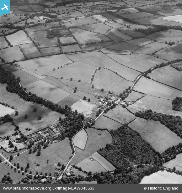
EAW043533 ENGLAND (1952). Bedwell Lodge Farm and surrounding countryside, Essendon, 1952
© Copyright OpenStreetMap contributors and licensed by the OpenStreetMap Foundation. 2025. Cartography is licensed as CC BY-SA.
Nearby Images (10)
Details
| Title | [EAW043533] Bedwell Lodge Farm and surrounding countryside, Essendon, 1952 |
| Reference | EAW043533 |
| Date | 4-June-1952 |
| Link | |
| Place name | ESSENDON |
| Parish | ESSENDON |
| District | |
| Country | ENGLAND |
| Easting / Northing | 527930, 207050 |
| Longitude / Latitude | -0.1466765469953, 51.747067890739 |
| National Grid Reference | TL279071 |
Pins
Be the first to add a comment to this image!


![[EAW043533] Bedwell Lodge Farm and surrounding countryside, Essendon, 1952](http://britainfromabove.org.uk/sites/all/libraries/aerofilms-images/public/100x100/EAW/043/EAW043533.jpg)
![[EAW043538] Bedwell Lodge and Farm, Essendon, 1952](http://britainfromabove.org.uk/sites/all/libraries/aerofilms-images/public/100x100/EAW/043/EAW043538.jpg)
![[EAW043541] Bedwell Lodge and Farm, Essendon, 1952](http://britainfromabove.org.uk/sites/all/libraries/aerofilms-images/public/100x100/EAW/043/EAW043541.jpg)
![[EAW043540] Bedwell Lodge, Essendon, 1952](http://britainfromabove.org.uk/sites/all/libraries/aerofilms-images/public/100x100/EAW/043/EAW043540.jpg)
![[EAW043537] Bedwell Lodge and Cucumber Hall Farm, Essendon, 1952](http://britainfromabove.org.uk/sites/all/libraries/aerofilms-images/public/100x100/EAW/043/EAW043537.jpg)
![[EAW043536] Bedwell Lodge, Essendon, 1952](http://britainfromabove.org.uk/sites/all/libraries/aerofilms-images/public/100x100/EAW/043/EAW043536.jpg)
![[EAW043542] Bedwell Lodge, Essendon, 1952](http://britainfromabove.org.uk/sites/all/libraries/aerofilms-images/public/100x100/EAW/043/EAW043542.jpg)
![[EAW043646] Bedwell Lodge Farm and surrounding countryside, Essendon, 1952](http://britainfromabove.org.uk/sites/all/libraries/aerofilms-images/public/100x100/EAW/043/EAW043646.jpg)
![[EAW043645] Bedwell Lodge Farm and surrounding countryside, Essendon, 1952](http://britainfromabove.org.uk/sites/all/libraries/aerofilms-images/public/100x100/EAW/043/EAW043645.jpg)
![[EAW043539] Bedwell Lodge and Farm, Essendon, 1952](http://britainfromabove.org.uk/sites/all/libraries/aerofilms-images/public/100x100/EAW/043/EAW043539.jpg)