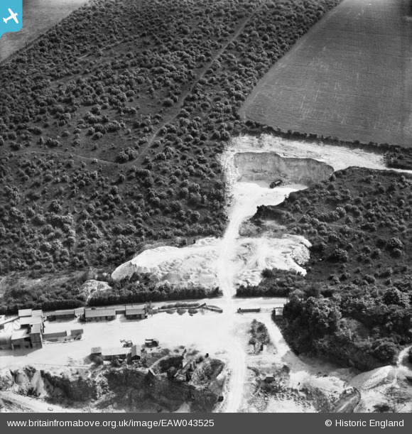
EAW043525 ENGLAND (1952). Part of the Sprotbrough Quarry, Sprotbrough, 1952
© Copyright OpenStreetMap contributors and licensed by the OpenStreetMap Foundation. 2025. Cartography is licensed as CC BY-SA.
Nearby Images (27)
Details
| Title | [EAW043525] Part of the Sprotbrough Quarry, Sprotbrough, 1952 |
| Reference | EAW043525 |
| Date | 21-May-1952 |
| Link | |
| Place name | SPROTBROUGH |
| Parish | SPROTBROUGH AND CUSWORTH |
| District | |
| Country | ENGLAND |
| Easting / Northing | 453312, 401354 |
| Longitude / Latitude | -1.1960943518922, 53.50592077002 |
| National Grid Reference | SE533014 |


![[EAW043525] Part of the Sprotbrough Quarry, Sprotbrough, 1952](http://britainfromabove.org.uk/sites/all/libraries/aerofilms-images/public/100x100/EAW/043/EAW043525.jpg)
![[EAW043526] Part of the Sprotbrough Quarry, Sprotbrough, 1952](http://britainfromabove.org.uk/sites/all/libraries/aerofilms-images/public/100x100/EAW/043/EAW043526.jpg)
![[EAW043521] Part of the Sprotbrough Quarry, Sprotbrough, 1952](http://britainfromabove.org.uk/sites/all/libraries/aerofilms-images/public/100x100/EAW/043/EAW043521.jpg)
![[EAW049686] Sprotbrough Plantation and quarrying on either side of Nursery Lane, Sprotbrough, 1953](http://britainfromabove.org.uk/sites/all/libraries/aerofilms-images/public/100x100/EAW/049/EAW049686.jpg)
![[EAW043524] Part of the Sprotbrough Quarry, Sprotbrough, 1952](http://britainfromabove.org.uk/sites/all/libraries/aerofilms-images/public/100x100/EAW/043/EAW043524.jpg)
![[EAW043523] The Sprotbrough Quarries, Sprotbrough, 1952](http://britainfromabove.org.uk/sites/all/libraries/aerofilms-images/public/100x100/EAW/043/EAW043523.jpg)
![[EAW049692] Quarrying on either side of Nursery Lane, Sprotbrough, 1953](http://britainfromabove.org.uk/sites/all/libraries/aerofilms-images/public/100x100/EAW/049/EAW049692.jpg)
![[EAW047504] Sprotbrough Quarries, Sprotbrough, 1952](http://britainfromabove.org.uk/sites/all/libraries/aerofilms-images/public/100x100/EAW/047/EAW047504.jpg)
![[EAW043522] Part of the Sprotbrough Quarry, Sprotbrough, 1952](http://britainfromabove.org.uk/sites/all/libraries/aerofilms-images/public/100x100/EAW/043/EAW043522.jpg)
![[EAW043516] Sprotbrough Quarry, Sprotbrough, 1952](http://britainfromabove.org.uk/sites/all/libraries/aerofilms-images/public/100x100/EAW/043/EAW043516.jpg)
![[EAW047505] Nursery Lane and Sprotbrough Quarries, Sprotbrough, 1952](http://britainfromabove.org.uk/sites/all/libraries/aerofilms-images/public/100x100/EAW/047/EAW047505.jpg)
![[EAW043517] Sprotbrough Quarry, Sprotbrough, 1952](http://britainfromabove.org.uk/sites/all/libraries/aerofilms-images/public/100x100/EAW/043/EAW043517.jpg)
![[EAW043514] Sprotbrough Quarry, Sprotbrough, 1952](http://britainfromabove.org.uk/sites/all/libraries/aerofilms-images/public/100x100/EAW/043/EAW043514.jpg)
![[EAW047498] Sprotbrough Quarries, Sprotbrough, 1952](http://britainfromabove.org.uk/sites/all/libraries/aerofilms-images/public/100x100/EAW/047/EAW047498.jpg)
![[EAW047499] Nursery Lane and Sprotbrough Quarries, Sprotbrough, 1952](http://britainfromabove.org.uk/sites/all/libraries/aerofilms-images/public/100x100/EAW/047/EAW047499.jpg)
![[EAW049687] Quarrying on either side of Nursery Lane, Sprotbrough, 1953](http://britainfromabove.org.uk/sites/all/libraries/aerofilms-images/public/100x100/EAW/049/EAW049687.jpg)
![[EAW043513] Sprotbrough Quarry, Sprotbrough, 1952](http://britainfromabove.org.uk/sites/all/libraries/aerofilms-images/public/100x100/EAW/043/EAW043513.jpg)
![[EAW049689] Sprotbrough Plantation, quarrying on either side of Nursery Lane and environs, Sprotbrough, 1953](http://britainfromabove.org.uk/sites/all/libraries/aerofilms-images/public/100x100/EAW/049/EAW049689.jpg)
![[EAW047501] Nursery Lane and Sprotbrough Quarries, Sprotbrough, 1952](http://britainfromabove.org.uk/sites/all/libraries/aerofilms-images/public/100x100/EAW/047/EAW047501.jpg)
![[EAW047500] Nursery Lane and Sprotbrough Quarries, Sprotbrough, 1952](http://britainfromabove.org.uk/sites/all/libraries/aerofilms-images/public/100x100/EAW/047/EAW047500.jpg)
![[EAW047503] Sprotbrough Quarries, Sprotbrough, 1952](http://britainfromabove.org.uk/sites/all/libraries/aerofilms-images/public/100x100/EAW/047/EAW047503.jpg)
![[EAW043496] Scabba Wood, Sprotbrough Quarry and Sprotbrough Plantation, Sprotbrough, 1952](http://britainfromabove.org.uk/sites/all/libraries/aerofilms-images/public/100x100/EAW/043/EAW043496.jpg)
![[EAW049691] Quarrying on either side of Nursery Lane, Sprotbrough, 1953](http://britainfromabove.org.uk/sites/all/libraries/aerofilms-images/public/100x100/EAW/049/EAW049691.jpg)
![[EAW047502] Sprotbrough Quarries, Sprotbrough, 1952](http://britainfromabove.org.uk/sites/all/libraries/aerofilms-images/public/100x100/EAW/047/EAW047502.jpg)
![[EAW043518] Sprotbrough Quarry, Sprotbrough, 1952](http://britainfromabove.org.uk/sites/all/libraries/aerofilms-images/public/100x100/EAW/043/EAW043518.jpg)
![[EAW043512] Sprotbrough Quarry, Sprotbrough, 1952](http://britainfromabove.org.uk/sites/all/libraries/aerofilms-images/public/100x100/EAW/043/EAW043512.jpg)
![[EAW043515] Sprotbrough Quarry, Sprotbrough, 1952](http://britainfromabove.org.uk/sites/all/libraries/aerofilms-images/public/100x100/EAW/043/EAW043515.jpg)
