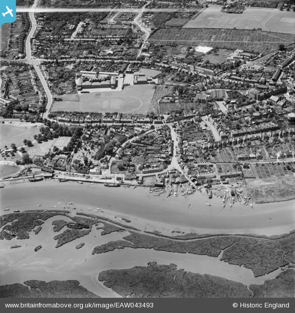
EAW043493 ENGLAND (1952). The Hythe, the River Chelmer and the town, Maldon, 1952
© Copyright OpenStreetMap contributors and licensed by the OpenStreetMap Foundation. 2026. Cartography is licensed as CC BY-SA.
Nearby Images (8)
Details
| Title | [EAW043493] The Hythe, the River Chelmer and the town, Maldon, 1952 |
| Reference | EAW043493 |
| Date | 3-June-1952 |
| Link | |
| Place name | MALDON |
| Parish | MALDON |
| District | |
| Country | ENGLAND |
| Easting / Northing | 585637, 206818 |
| Longitude / Latitude | 0.68836350758317, 51.728838848165 |
| National Grid Reference | TL856068 |
Pins

Stephen Mirrington |
Sunday 28th of September 2025 08:20:29 PM | |

Stephen Mirrington |
Sunday 28th of September 2025 08:18:54 PM |


![[EAW043493] The Hythe, the River Chelmer and the town, Maldon, 1952](http://britainfromabove.org.uk/sites/all/libraries/aerofilms-images/public/100x100/EAW/043/EAW043493.jpg)
![[EAW021830] The Hythe, North Street and environs, Maldon, 1949. This image has been produced from a print.](http://britainfromabove.org.uk/sites/all/libraries/aerofilms-images/public/100x100/EAW/021/EAW021830.jpg)
![[EPW054678] The Hythe, Maldon, 1937](http://britainfromabove.org.uk/sites/all/libraries/aerofilms-images/public/100x100/EPW/054/EPW054678.jpg)
![[EAW021829] North Street and environs, Maldon, from the north-east, 1949. This image has been produced from a print.](http://britainfromabove.org.uk/sites/all/libraries/aerofilms-images/public/100x100/EAW/021/EAW021829.jpg)
![[EPW054680] Victoria Road, Maldon, 1937](http://britainfromabove.org.uk/sites/all/libraries/aerofilms-images/public/100x100/EPW/054/EPW054680.jpg)
![[EAW001532] The River Blackwater at The Hythe, Maldon, from the north-west, 1946](http://britainfromabove.org.uk/sites/all/libraries/aerofilms-images/public/100x100/EAW/001/EAW001532.jpg)
![[EAW021828] St Mary's Church and environs, Maldon, 1949. This image has been produced from a print.](http://britainfromabove.org.uk/sites/all/libraries/aerofilms-images/public/100x100/EAW/021/EAW021828.jpg)
![[EAW001530] The High Street and environs, Maldon, 1946](http://britainfromabove.org.uk/sites/all/libraries/aerofilms-images/public/100x100/EAW/001/EAW001530.jpg)