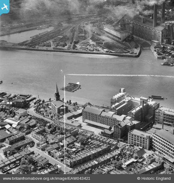
EAW043421 ENGLAND (1952). Battersea Flour Mills and St Mary's Church, Battersea, 1952. This image was marked by Aerofilms Ltd for photo editing.
© Copyright OpenStreetMap contributors and licensed by the OpenStreetMap Foundation. 2026. Cartography is licensed as CC BY-SA.
Nearby Images (8)
Details
| Title | [EAW043421] Battersea Flour Mills and St Mary's Church, Battersea, 1952. This image was marked by Aerofilms Ltd for photo editing. |
| Reference | EAW043421 |
| Date | 28-May-1952 |
| Link | |
| Place name | BATTERSEA |
| Parish | |
| District | |
| Country | ENGLAND |
| Easting / Northing | 526698, 176955 |
| Longitude / Latitude | -0.17539514521384, 51.476861739714 |
| National Grid Reference | TQ267770 |
Pins

Leslie B |
Tuesday 4th of October 2022 06:44:03 PM | |

Leslie B |
Tuesday 4th of October 2022 06:24:13 PM | |

John W |
Saturday 24th of September 2016 09:23:03 PM | |

John W |
Saturday 24th of September 2016 09:17:14 PM | |

John W |
Saturday 24th of September 2016 09:13:41 PM | |

Alan McFaden |
Sunday 15th of June 2014 03:46:09 PM | |

Alan McFaden |
Tuesday 10th of June 2014 08:57:12 PM |
User Comment Contributions
Chelsea Harbour, 23/09/2014 |

Class31 |
Monday 26th of September 2016 07:22:32 AM |
Lots Road Power Station, 20/05/2015 |

Class31 |
Monday 26th of September 2016 07:20:20 AM |
St. Mary's Church, Battersea, 20/05/2015 |

Class31 |
Monday 26th of September 2016 07:18:34 AM |
St. Mary's Church, Battersea, 20/05/2015 |

Class31 |
Monday 26th of September 2016 07:17:18 AM |


![[EAW043421] Battersea Flour Mills and St Mary's Church, Battersea, 1952. This image was marked by Aerofilms Ltd for photo editing.](http://britainfromabove.org.uk/sites/all/libraries/aerofilms-images/public/100x100/EAW/043/EAW043421.jpg)
![[EAW043424] Battersea Flour Mills and St Mary's Church, Battersea, 1952. This image was marked by Aerofilms Ltd for photo editing.](http://britainfromabove.org.uk/sites/all/libraries/aerofilms-images/public/100x100/EAW/043/EAW043424.jpg)
![[EAW043422] The River Thames at Battersea Flour Mills and St Mary's Church, Battersea, 1952. This image was marked by Aerofilms Ltd for photo editing.](http://britainfromabove.org.uk/sites/all/libraries/aerofilms-images/public/100x100/EAW/043/EAW043422.jpg)
![[EAW009111] The River Thames and environs from Lots Road Power Station to Battersea Power Station, Chelsea, from the south-west, 1947](http://britainfromabove.org.uk/sites/all/libraries/aerofilms-images/public/100x100/EAW/009/EAW009111.jpg)
![[EAW043420] Battersea Flour Mills, Battersea, 1952. This image was marked by Aerofilms Ltd for photo editing.](http://britainfromabove.org.uk/sites/all/libraries/aerofilms-images/public/100x100/EAW/043/EAW043420.jpg)
![[EAW004907] The River Thames between Chelsea and Battersea, Sands End, from the south-west, 1947](http://britainfromabove.org.uk/sites/all/libraries/aerofilms-images/public/100x100/EAW/004/EAW004907.jpg)
![[EPW052295] Lots Road Power Station and the River Thames, Chelsea, 1936. This image has been produced from a copy-negative.](http://britainfromabove.org.uk/sites/all/libraries/aerofilms-images/public/100x100/EPW/052/EPW052295.jpg)
![[EAW043423] Battersea Flour Mills and St Mary's Church, Battersea, 1952. This image was marked by Aerofilms Ltd for photo editing.](http://britainfromabove.org.uk/sites/all/libraries/aerofilms-images/public/100x100/EAW/043/EAW043423.jpg)


