
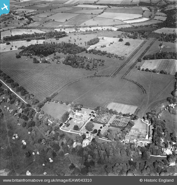
EAW043310 ENGLAND (1952). Hardwick Hall and surrounding countryside, Hardwick Park, 1952
© Copyright OpenStreetMap contributors and licensed by the OpenStreetMap Foundation. 2026. Cartography is licensed as CC BY-SA.
Nearby Images (2)
EAW043310

EAW043311

Details
| Title | [EAW043310] Hardwick Hall and surrounding countryside, Hardwick Park, 1952 |
| Reference | EAW043310 |
| Date | 23-May-1952 |
| Link | |
| Place name | HARDWICK PARK |
| Parish | AULT HUCKNALL |
| District | |
| Country | ENGLAND |
| Easting / Northing | 446565, 363837 |
| Longitude / Latitude | -1.3033428995773, 53.169319936642 |
| National Grid Reference | SK466638 |
Pins
Rob |
Monday 25th of March 2024 02:50:44 PM | |
|
Rob |
Monday 25th of March 2024 02:46:24 PM | |
|
Rob |
Monday 25th of March 2024 02:24:12 PM | |

Stuart Redding |
Wednesday 2nd of March 2016 10:05:22 PM | |
|
John01623 |
Wednesday 11th of June 2014 02:51:17 PM |


User Comment Contributions
For more details on the hall, see en.wikipedia.org/wiki/Hardwick_Hall and www.nationaltrust.org.uk/hardwick/ |

melgibbs |
Thursday 21st of August 2014 10:16:10 AM |