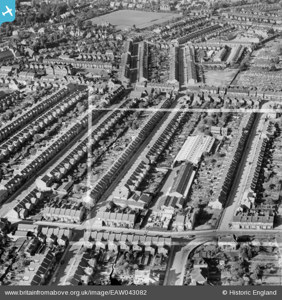
EAW043082 ENGLAND (1952). Whippendell Road and the Standard Range and Foundry Co Ltd Works between Chester Road and Benskin Road, Watford, 1952. This image was marked by Aerofilms Ltd for photo editing.
© Copyright OpenStreetMap contributors and licensed by the OpenStreetMap Foundation. 2025. Cartography is licensed as CC BY-SA.
Nearby Images (7)
Details
| Title | [EAW043082] Whippendell Road and the Standard Range and Foundry Co Ltd Works between Chester Road and Benskin Road, Watford, 1952. This image was marked by Aerofilms Ltd for photo editing. |
| Reference | EAW043082 |
| Date | 17-May-1952 |
| Link | |
| Place name | WATFORD |
| Parish | |
| District | |
| Country | ENGLAND |
| Easting / Northing | 510161, 195920 |
| Longitude / Latitude | -0.40749666192809, 51.650799944383 |
| National Grid Reference | TQ102959 |
Pins
Be the first to add a comment to this image!


![[EAW043082] Whippendell Road and the Standard Range and Foundry Co Ltd Works between Chester Road and Benskin Road, Watford, 1952. This image was marked by Aerofilms Ltd for photo editing.](http://britainfromabove.org.uk/sites/all/libraries/aerofilms-images/public/100x100/EAW/043/EAW043082.jpg)
![[EAW043085] The Standard Range and Foundry Co Ltd Works and surrounding residential streets, Watford, 1952. This image was marked by Aerofilms Ltd for photo editing.](http://britainfromabove.org.uk/sites/all/libraries/aerofilms-images/public/100x100/EAW/043/EAW043085.jpg)
![[EAW043083] The Standard Range and Foundry Co Ltd Works between Chester Road and Benskin Road, Watford, 1952. This image was marked by Aerofilms Ltd for photo editing.](http://britainfromabove.org.uk/sites/all/libraries/aerofilms-images/public/100x100/EAW/043/EAW043083.jpg)
![[EAW043079] The Standard Range and Foundry Co Ltd Works between Chester Road and Benskin Road, Watford, 1952. This image has been produced from a damaged negative.](http://britainfromabove.org.uk/sites/all/libraries/aerofilms-images/public/100x100/EAW/043/EAW043079.jpg)
![[EAW043078] The Standard Range and Foundry Co Ltd Works between Chester Road and Benskin Road, Watford, 1952. This image has been produced from a damaged negative.](http://britainfromabove.org.uk/sites/all/libraries/aerofilms-images/public/100x100/EAW/043/EAW043078.jpg)
![[EAW043084] The Standard Range and Foundry Co Ltd Works between Chester Road and Benskin Road, Watford, 1952. This image was marked by Aerofilms Ltd for photo editing.](http://britainfromabove.org.uk/sites/all/libraries/aerofilms-images/public/100x100/EAW/043/EAW043084.jpg)
![[EAW043080] Queen's Avenue and the Standard Range and Foundry Co Ltd Works between Chester Road and Benskin Road, Watford, 1952. This image has been produced from a prints marked by Aerofilms Ltd for photo editing.](http://britainfromabove.org.uk/sites/all/libraries/aerofilms-images/public/100x100/EAW/043/EAW043080.jpg)