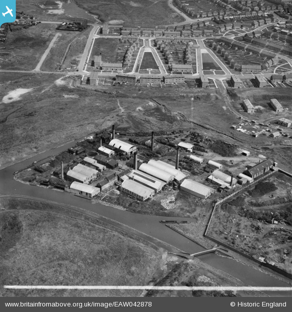
EAW042878 ENGLAND (1952). The W. H. Keys Ltd Hall End Works, Hateley Heath, 1952. This image was marked by Aerofilms Ltd for photo editing.
© Copyright OpenStreetMap contributors and licensed by the OpenStreetMap Foundation. 2026. Cartography is licensed as CC BY-SA.
Nearby Images (35)
Details
| Title | [EAW042878] The W. H. Keys Ltd Hall End Works, Hateley Heath, 1952. This image was marked by Aerofilms Ltd for photo editing. |
| Reference | EAW042878 |
| Date | 5-July-1952 |
| Link | |
| Place name | HATELEY HEATH |
| Parish | |
| District | |
| Country | ENGLAND |
| Easting / Northing | 400075, 292936 |
| Longitude / Latitude | -1.9988942013057, 52.533925725768 |
| National Grid Reference | SP001929 |
Pins

DaveT |
Sunday 27th of April 2014 03:21:26 PM |


![[EAW042878] The W. H. Keys Ltd Hall End Works, Hateley Heath, 1952. This image was marked by Aerofilms Ltd for photo editing.](http://britainfromabove.org.uk/sites/all/libraries/aerofilms-images/public/100x100/EAW/042/EAW042878.jpg)
![[EAW042876] The W. H. Keys Ltd Hall End Works, Hateley Heath, 1952. This image was marked by Aerofilms Ltd for photo editing.](http://britainfromabove.org.uk/sites/all/libraries/aerofilms-images/public/100x100/EAW/042/EAW042876.jpg)
![[EAW042869] The W. H. Keys Ltd Hall End Works, Hateley Heath, 1952. This image was marked by Aerofilms Ltd for photo editing.](http://britainfromabove.org.uk/sites/all/libraries/aerofilms-images/public/100x100/EAW/042/EAW042869.jpg)
![[EAW042881] The W. H. Keys Ltd Hall End Works, Hateley Heath, 1952. This image was marked by Aerofilms Ltd for photo editing.](http://britainfromabove.org.uk/sites/all/libraries/aerofilms-images/public/100x100/EAW/042/EAW042881.jpg)
![[EAW042875] The W. H. Keys Ltd Hall End Works, Hateley Heath, 1952. This image was marked by Aerofilms Ltd for photo editing.](http://britainfromabove.org.uk/sites/all/libraries/aerofilms-images/public/100x100/EAW/042/EAW042875.jpg)
![[EAW042196] The W. H. Keys Ltd Hall End Works, Hateley Heath, 1952. This image was marked by Aerofilms Ltd for photo editing.](http://britainfromabove.org.uk/sites/all/libraries/aerofilms-images/public/100x100/EAW/042/EAW042196.jpg)
![[EAW042198] The W. H. Keys Ltd Hall End Works, Hateley Heath, 1952. This image was marked by Aerofilms Ltd for photo editing.](http://britainfromabove.org.uk/sites/all/libraries/aerofilms-images/public/100x100/EAW/042/EAW042198.jpg)
![[EAW042195] The W. H. Keys Ltd Hall End Works, Hateley Heath, 1952. This image was marked by Aerofilms Ltd for photo editing.](http://britainfromabove.org.uk/sites/all/libraries/aerofilms-images/public/100x100/EAW/042/EAW042195.jpg)
![[EAW042879] The W. H. Keys Ltd Hall End Works, Hateley Heath, 1952. This image was marked by Aerofilms Ltd for photo editing.](http://britainfromabove.org.uk/sites/all/libraries/aerofilms-images/public/100x100/EAW/042/EAW042879.jpg)
![[EAW042201] The W. H. Keys Ltd Hall End Works, Hateley Heath, 1952. This image has been produced from a print marked by Aerofilms Ltd for photo editing.](http://britainfromabove.org.uk/sites/all/libraries/aerofilms-images/public/100x100/EAW/042/EAW042201.jpg)
![[EAW042873] The W. H. Keys Ltd Hall End Works, Hateley Heath, 1952. This image was marked by Aerofilms Ltd for photo editing.](http://britainfromabove.org.uk/sites/all/libraries/aerofilms-images/public/100x100/EAW/042/EAW042873.jpg)
![[EAW042870] The W. H. Keys Ltd Hall End Works, Hateley Heath, 1952. This image was marked by Aerofilms Ltd for photo editing.](http://britainfromabove.org.uk/sites/all/libraries/aerofilms-images/public/100x100/EAW/042/EAW042870.jpg)
![[EAW042871] The W. H. Keys Ltd Hall End Works, Hateley Heath, 1952. This image was marked by Aerofilms Ltd for photo editing.](http://britainfromabove.org.uk/sites/all/libraries/aerofilms-images/public/100x100/EAW/042/EAW042871.jpg)
![[EAW042197] The W. H. Keys Ltd Hall End Works, Hateley Heath, 1952. This image was marked by Aerofilms Ltd for photo editing.](http://britainfromabove.org.uk/sites/all/libraries/aerofilms-images/public/100x100/EAW/042/EAW042197.jpg)
![[EAW042872] The W. H. Keys Ltd Hall End Works, Hateley Heath, 1952. This image was marked by Aerofilms Ltd for photo editing.](http://britainfromabove.org.uk/sites/all/libraries/aerofilms-images/public/100x100/EAW/042/EAW042872.jpg)
![[EAW042203] The W. H. Keys Ltd Hall End Works, Hateley Heath, 1952. This image has been produced from a print marked by Aerofilms Ltd for photo editing.](http://britainfromabove.org.uk/sites/all/libraries/aerofilms-images/public/100x100/EAW/042/EAW042203.jpg)
![[EAW042204] The W. H. Keys Ltd Hall End Works, Hateley Heath, 1952. This image has been produced from a print marked by Aerofilms Ltd for photo editing.](http://britainfromabove.org.uk/sites/all/libraries/aerofilms-images/public/100x100/EAW/042/EAW042204.jpg)
![[EAW042877] The W. H. Keys Ltd Hall End Works, Hateley Heath, 1952. This image was marked by Aerofilms Ltd for photo editing.](http://britainfromabove.org.uk/sites/all/libraries/aerofilms-images/public/100x100/EAW/042/EAW042877.jpg)
![[EAW042205] The W. H. Keys Ltd Hall End Works, Hateley Heath, 1952. This image has been produced from a print marked by Aerofilms Ltd for photo editing.](http://britainfromabove.org.uk/sites/all/libraries/aerofilms-images/public/100x100/EAW/042/EAW042205.jpg)
![[EAW042202] The W. H. Keys Ltd Hall End Works, Hateley Heath, 1952. This image has been produced from a print marked by Aerofilms Ltd for photo editing.](http://britainfromabove.org.uk/sites/all/libraries/aerofilms-images/public/100x100/EAW/042/EAW042202.jpg)
![[EAW042200] The W. H. Keys Ltd Hall End Works, Hateley Heath, 1952. This image has been produced from a print marked by Aerofilms Ltd for photo editing.](http://britainfromabove.org.uk/sites/all/libraries/aerofilms-images/public/100x100/EAW/042/EAW042200.jpg)
![[EAW042880] The W. H. Keys Ltd Hall End Works, Hateley Heath, 1952. This image was marked by Aerofilms Ltd for photo editing.](http://britainfromabove.org.uk/sites/all/libraries/aerofilms-images/public/100x100/EAW/042/EAW042880.jpg)
![[EAW042874] The W. H. Keys Ltd Hall End Works, Hateley Heath, 1952. This image was marked by Aerofilms Ltd for photo editing.](http://britainfromabove.org.uk/sites/all/libraries/aerofilms-images/public/100x100/EAW/042/EAW042874.jpg)
![[EAW042199] The W. H. Keys Ltd Hall End Works, Hateley Heath, 1952. This image was marked by Aerofilms Ltd for photo editing.](http://britainfromabove.org.uk/sites/all/libraries/aerofilms-images/public/100x100/EAW/042/EAW042199.jpg)
![[EAW048805] Johnson Iron and Steel Co Ltd Hall End Works, West Bromwich, 1953. This image was marked by Aerofilms Ltd for photo editing.](http://britainfromabove.org.uk/sites/all/libraries/aerofilms-images/public/100x100/EAW/048/EAW048805.jpg)
![[EAW020371] The Johnson's Iron & Steel Co Ltd Hall End Iron Works, Birmingham Canal Navigations (Halford Branch) and environs, West Bromwich, 1948](http://britainfromabove.org.uk/sites/all/libraries/aerofilms-images/public/100x100/EAW/020/EAW020371.jpg)
![[EAW048802] Johnson Iron and Steel Co Ltd Hall End Works and environs, West Bromwich, from the south-east, 1953](http://britainfromabove.org.uk/sites/all/libraries/aerofilms-images/public/100x100/EAW/048/EAW048802.jpg)
![[EAW020381] the Birmingham Canal Naviigations (Halford Branch), the Johnson's Iron & Steel Co Ltd Hall End Iron Works and environs, West Bromwich, 1948. This image was marked by Aerofilms Ltd for photo editing.](http://britainfromabove.org.uk/sites/all/libraries/aerofilms-images/public/100x100/EAW/020/EAW020381.jpg)
![[EAW020370] The Johnson's Iron & Steel Co Ltd Hall End Iron Works, Birmingham Canal Navigations (Halford Branch) and environs, West Bromwich, 1948](http://britainfromabove.org.uk/sites/all/libraries/aerofilms-images/public/100x100/EAW/020/EAW020370.jpg)
![[EAW048806] Johnson Iron and Steel Co Ltd Hall End Works and environs, West Bromwich, from the north-west, 1953. This image was marked by Aerofilms Ltd for photo editing.](http://britainfromabove.org.uk/sites/all/libraries/aerofilms-images/public/100x100/EAW/048/EAW048806.jpg)
![[EAW020369] The Johnson's Iron & Steel Co Ltd Hall End Iron Works and environs, West Bromwich, 1948. This image was marked by Aerofilms Ltd for photo editing.](http://britainfromabove.org.uk/sites/all/libraries/aerofilms-images/public/100x100/EAW/020/EAW020369.jpg)
![[EAW020379] The Johnson's Iron & Steel Co Ltd Hall End Iron Works and environs, West Bromwich, 1948. This image was marked by Aerofilms Ltd for photo editing.](http://britainfromabove.org.uk/sites/all/libraries/aerofilms-images/public/100x100/EAW/020/EAW020379.jpg)
![[EAW048804] Johnson Iron and Steel Co Ltd Hall End Works and environs, West Bromwich, 1953. This image was marked by Aerofilms Ltd for photo editing.](http://britainfromabove.org.uk/sites/all/libraries/aerofilms-images/public/100x100/EAW/048/EAW048804.jpg)
![[EAW020372] The Johnson's Iron & Steel Co Ltd Hall End Iron Works looking towards Hall Ends, West Bromwich, from the west, 1948. This image was marked by Aerofilms Ltd for photo editing.](http://britainfromabove.org.uk/sites/all/libraries/aerofilms-images/public/100x100/EAW/020/EAW020372.jpg)
![[EAW020373] The Johnson's Iron & Steel Co Ltd Hall End Iron Works looking towards Hall Ends, West Bromwich, from the west, 1948. This image was marked by Aerofilms Ltd for photo editing.](http://britainfromabove.org.uk/sites/all/libraries/aerofilms-images/public/100x100/EAW/020/EAW020373.jpg)