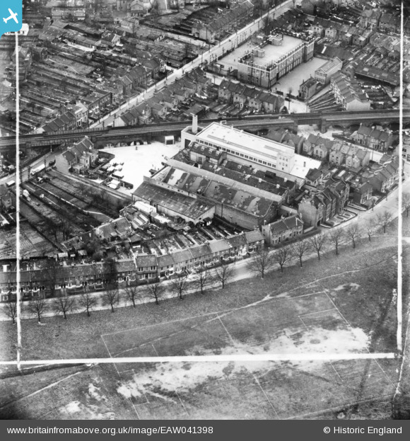
EAW041398 ENGLAND (1951). The H. W. Nevill Ltd Bakery off Harrow Road, Leytonstone, 1951. This image has been produced from a print marked by Aerofilms Ltd for photo editing.
© Copyright OpenStreetMap contributors and licensed by the OpenStreetMap Foundation. 2026. Cartography is licensed as CC BY-SA.
Nearby Images (13)
Details
| Title | [EAW041398] The H. W. Nevill Ltd Bakery off Harrow Road, Leytonstone, 1951. This image has been produced from a print marked by Aerofilms Ltd for photo editing. |
| Reference | EAW041398 |
| Date | 22-November-1951 |
| Link | |
| Place name | LEYTONSTONE |
| Parish | |
| District | |
| Country | ENGLAND |
| Easting / Northing | 539855, 186362 |
| Longitude / Latitude | 0.017694924802309, 51.558301553866 |
| National Grid Reference | TQ399864 |
Pins

Roger |
Thursday 26th of January 2023 12:22:48 AM | |

Roger |
Thursday 26th of January 2023 12:13:24 AM | |

Hermann the German |
Tuesday 5th of September 2017 09:17:39 PM | |

Hermann the German |
Tuesday 5th of September 2017 09:11:31 PM | |

Hermann the German |
Tuesday 5th of September 2017 09:05:04 PM | |

Hermann the German |
Tuesday 5th of September 2017 09:03:20 PM |


![[EAW041398] The H. W. Nevill Ltd Bakery off Harrow Road, Leytonstone, 1951. This image has been produced from a print marked by Aerofilms Ltd for photo editing.](http://britainfromabove.org.uk/sites/all/libraries/aerofilms-images/public/100x100/EAW/041/EAW041398.jpg)
![[EAW041397] The H. W. Nevill Ltd Bakery off Harrow Road, Leytonstone, 1951. This image has been produced from a print marked by Aerofilms Ltd for photo editing.](http://britainfromabove.org.uk/sites/all/libraries/aerofilms-images/public/100x100/EAW/041/EAW041397.jpg)
![[EAW041400] The H. W. Nevill Ltd Bakery off Harrow Road, Leytonstone, 1951. This image was marked by Aerofilms Ltd for photo editing.](http://britainfromabove.org.uk/sites/all/libraries/aerofilms-images/public/100x100/EAW/041/EAW041400.jpg)
![[EAW041399] The H. W. Nevill Ltd Bakery off Harrow Road, Leytonstone, 1951. This image has been produced from a print marked by Aerofilms Ltd for photo editing.](http://britainfromabove.org.uk/sites/all/libraries/aerofilms-images/public/100x100/EAW/041/EAW041399.jpg)
![[EAW041395] The H. W. Nevill Ltd Bakery off Harrow Road and adjacent railway viaduct, Leytonstone, 1951. This image has been produced from a print marked by Aerofilms Ltd for photo editing.](http://britainfromabove.org.uk/sites/all/libraries/aerofilms-images/public/100x100/EAW/041/EAW041395.jpg)
![[EAW041396] The H. W. Nevill Ltd Bakery off Harrow Road, Leytonstone, 1951. This image has been produced from a print marked by Aerofilms Ltd for photo editing.](http://britainfromabove.org.uk/sites/all/libraries/aerofilms-images/public/100x100/EAW/041/EAW041396.jpg)
![[EAW041402] The H. W. Nevill Ltd Bakery off Harrow Road and adjacent railway viaduct, Leytonstone, 1951. This image has been produced from a print marked by Aerofilms Ltd for photo editing.](http://britainfromabove.org.uk/sites/all/libraries/aerofilms-images/public/100x100/EAW/041/EAW041402.jpg)
![[EAW041405] The H. W. Nevill Ltd Bakery off Harrow Road and adjacent railway viaduct, Leytonstone, 1951. This image has been produced from a print marked by Aerofilms Ltd for photo editing.](http://britainfromabove.org.uk/sites/all/libraries/aerofilms-images/public/100x100/EAW/041/EAW041405.jpg)
![[EAW041394] The H. W. Nevill Ltd Bakery off Harrow Road and adjacent railway viaduct, Leytonstone, 1951. This image has been produced from a print marked by Aerofilms Ltd for photo editing.](http://britainfromabove.org.uk/sites/all/libraries/aerofilms-images/public/100x100/EAW/041/EAW041394.jpg)
![[EAW041403] The H. W. Nevill Ltd Bakery off Harrow Road and adjacent railway viaduct, Leytonstone, 1951. This image has been produced from a print marked by Aerofilms Ltd for photo editing.](http://britainfromabove.org.uk/sites/all/libraries/aerofilms-images/public/100x100/EAW/041/EAW041403.jpg)
![[EAW041401] The H. W. Nevill Ltd Bakery (site of) off Harrow Road, Leytonstone, 1951. This image has been produced from a damaged negative.](http://britainfromabove.org.uk/sites/all/libraries/aerofilms-images/public/100x100/EAW/041/EAW041401.jpg)
![[EAW041404] Cobbold Road, the H. W. Nevill Ltd Bakery off Harrow Road and adjacent railway viaduct, Leytonstone, 1951. This image has been produced from a print marked by Aerofilms Ltd for photo editing.](http://britainfromabove.org.uk/sites/all/libraries/aerofilms-images/public/100x100/EAW/041/EAW041404.jpg)
![[EPW026951] Funfair at Wanstead Flats, Wanstead, 1929](http://britainfromabove.org.uk/sites/all/libraries/aerofilms-images/public/100x100/EPW/026/EPW026951.jpg)