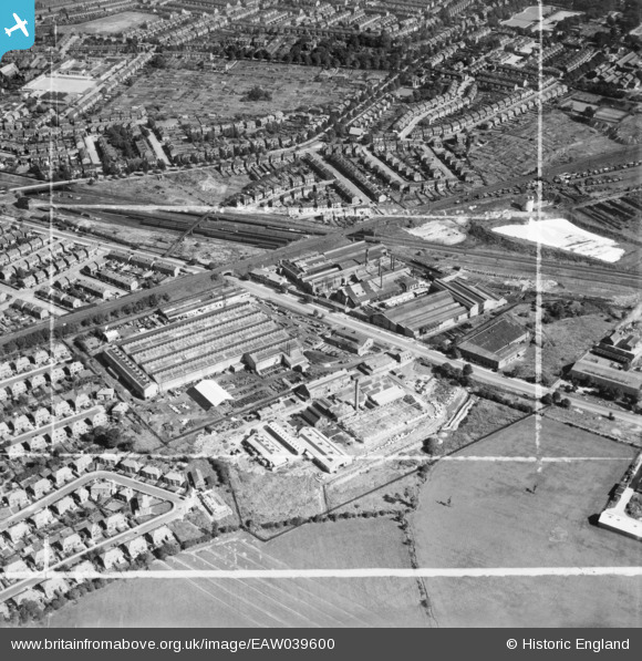
EAW039600 ENGLAND (1951). The Oil Well Co Ltd Engineering Works, Cheadle Heath, 1951. This image was marked by Aerofilms Ltd for photo editing.
© Copyright OpenStreetMap contributors and licensed by the OpenStreetMap Foundation. 2026. Cartography is licensed as CC BY-SA.
Nearby Images (30)
Details
| Title | [EAW039600] The Oil Well Co Ltd Engineering Works, Cheadle Heath, 1951. This image was marked by Aerofilms Ltd for photo editing. |
| Reference | EAW039600 |
| Date | 9-September-1951 |
| Link | |
| Place name | CHEADLE HEATH |
| Parish | |
| District | |
| Country | ENGLAND |
| Easting / Northing | 387748, 388798 |
| Longitude / Latitude | -2.1842713711284, 53.395608931262 |
| National Grid Reference | SJ877888 |
Pins
Be the first to add a comment to this image!


![[EAW039600] The Oil Well Co Ltd Engineering Works, Cheadle Heath, 1951. This image was marked by Aerofilms Ltd for photo editing.](http://britainfromabove.org.uk/sites/all/libraries/aerofilms-images/public/100x100/EAW/039/EAW039600.jpg)
![[EPW049689] The Oil Well Engineering Company Works, Stockport, 1936](http://britainfromabove.org.uk/sites/all/libraries/aerofilms-images/public/100x100/EPW/049/EPW049689.jpg)
![[EAW000409] The Oil Well Engineering Works, Cheadle Heath, 1946. This image has been produced from a damaged negative.](http://britainfromabove.org.uk/sites/all/libraries/aerofilms-images/public/100x100/EAW/000/EAW000409.jpg)
![[EAW039601] The Oil Well Co Ltd Engineering Works, Cheadle Heath, 1951. This image was marked by Aerofilms Ltd for photo editing.](http://britainfromabove.org.uk/sites/all/libraries/aerofilms-images/public/100x100/EAW/039/EAW039601.jpg)
![[EPW049692] The Oil Well Engineering Company Works, Stockport, 1936](http://britainfromabove.org.uk/sites/all/libraries/aerofilms-images/public/100x100/EPW/049/EPW049692.jpg)
![[EAW039596] The Oil Well Co Ltd Engineering Works, Cheadle Heath, 1951. This image was marked by Aerofilms Ltd for photo editing.](http://britainfromabove.org.uk/sites/all/libraries/aerofilms-images/public/100x100/EAW/039/EAW039596.jpg)
![[EAW000401] The Oil Well Engineering Works, Cheadle Heath, 1946. This image has been produced from a damaged negative.](http://britainfromabove.org.uk/sites/all/libraries/aerofilms-images/public/100x100/EAW/000/EAW000401.jpg)
![[EAW000403] The Oil Well Engineering Works, Cheadle Heath, 1946. This image has been produced from a damaged negative.](http://britainfromabove.org.uk/sites/all/libraries/aerofilms-images/public/100x100/EAW/000/EAW000403.jpg)
![[EAW039598] The Oil Well Co Ltd Engineering Works, Cheadle Heath, 1951. This image was marked by Aerofilms Ltd for photo editing.](http://britainfromabove.org.uk/sites/all/libraries/aerofilms-images/public/100x100/EAW/039/EAW039598.jpg)
![[EAW000400] The Oil Well Engineering Works, Cheadle Heath, 1946. This image has been produced from a damaged negative.](http://britainfromabove.org.uk/sites/all/libraries/aerofilms-images/public/100x100/EAW/000/EAW000400.jpg)
![[EAW000405] The Oil Well Engineering Works and the surrounding residential area, Cheadle Heath, 1946. This image has been produced from a damaged negative.](http://britainfromabove.org.uk/sites/all/libraries/aerofilms-images/public/100x100/EAW/000/EAW000405.jpg)
![[EAW039597] The Oil Well Co Ltd Engineering Works, Cheadle Heath, 1951. This image was marked by Aerofilms Ltd for photo editing.](http://britainfromabove.org.uk/sites/all/libraries/aerofilms-images/public/100x100/EAW/039/EAW039597.jpg)
![[EPW016700] The Oil Well Engineering Works, Cheadle Heath, 1926](http://britainfromabove.org.uk/sites/all/libraries/aerofilms-images/public/100x100/EPW/016/EPW016700.jpg)
![[EAW039599] The Oil Well Co Ltd Engineering Works, Cheadle Heath, 1951. This image was marked by Aerofilms Ltd for photo editing.](http://britainfromabove.org.uk/sites/all/libraries/aerofilms-images/public/100x100/EAW/039/EAW039599.jpg)
![[EPW049690] The Oil Well Engineering Company Works, Stockport, 1936](http://britainfromabove.org.uk/sites/all/libraries/aerofilms-images/public/100x100/EPW/049/EPW049690.jpg)
![[EAW052660] British-Driver Harris Co Ltd Works off Bird Hall Lane and environs, Cheadle Hulme, 1953](http://britainfromabove.org.uk/sites/all/libraries/aerofilms-images/public/100x100/EAW/052/EAW052660.jpg)
![[EPW049693] The Oil Well Engineering Company Works and environs, Stockport, 1936](http://britainfromabove.org.uk/sites/all/libraries/aerofilms-images/public/100x100/EPW/049/EPW049693.jpg)
![[EAW000402] The Oil Well Engineering Works, Cheadle Heath, 1946. This image has been produced from a damaged negative.](http://britainfromabove.org.uk/sites/all/libraries/aerofilms-images/public/100x100/EAW/000/EAW000402.jpg)
![[EPW049691] The Oil Well Engineering Company Works and the Mersey Works, Stockport, 1936](http://britainfromabove.org.uk/sites/all/libraries/aerofilms-images/public/100x100/EPW/049/EPW049691.jpg)
![[EAW000407] The Oil Well Engineering Works, Cheadle Heath, 1946. This image has been produced from a damaged negative.](http://britainfromabove.org.uk/sites/all/libraries/aerofilms-images/public/100x100/EAW/000/EAW000407.jpg)
![[EAW052657] British-Driver Harris Co Ltd Works off Bird Hall Lane, Cheadle Hulme, 1953. This image was marked by Aerofilms Ltd for photo editing.](http://britainfromabove.org.uk/sites/all/libraries/aerofilms-images/public/100x100/EAW/052/EAW052657.jpg)
![[EAW000404] The Oil Well Engineering Works and the surrounding residential area, Cheadle Heath, 1946. This image has been produced from a damaged negative.](http://britainfromabove.org.uk/sites/all/libraries/aerofilms-images/public/100x100/EAW/000/EAW000404.jpg)
![[EAW052661] British-Driver Harris Co Ltd Works off Bird Hall Lane, Cheadle Hulme, 1953. This image was marked by Aerofilms Ltd for photo editing.](http://britainfromabove.org.uk/sites/all/libraries/aerofilms-images/public/100x100/EAW/052/EAW052661.jpg)
![[EAW052656] British-Driver Harris Co Ltd Works off Bird Hall Lane, Cheadle Hulme, 1953. This image was marked by Aerofilms Ltd for photo editing.](http://britainfromabove.org.uk/sites/all/libraries/aerofilms-images/public/100x100/EAW/052/EAW052656.jpg)
![[EAW000408] The Oil Well Engineering Works, Cheadle Heath, 1946. This image has been produced from a damaged negative.](http://britainfromabove.org.uk/sites/all/libraries/aerofilms-images/public/100x100/EAW/000/EAW000408.jpg)
![[EAW052659] British-Driver Harris Co Ltd Works off Bird Hall Lane, Cheadle Hulme, 1953. This image was marked by Aerofilms Ltd for photo editing.](http://britainfromabove.org.uk/sites/all/libraries/aerofilms-images/public/100x100/EAW/052/EAW052659.jpg)
![[EAW052654] British-Driver Harris Co Ltd Works off Bird Hall Lane, Cheadle Hulme, 1953. This image was marked by Aerofilms Ltd for photo editing.](http://britainfromabove.org.uk/sites/all/libraries/aerofilms-images/public/100x100/EAW/052/EAW052654.jpg)
![[EAW000406] The Oil Well Engineering Works and environs, Cheadle Heath, 1946. This image has been produced from a damaged negative.](http://britainfromabove.org.uk/sites/all/libraries/aerofilms-images/public/100x100/EAW/000/EAW000406.jpg)
![[EAW052658] British-Driver Harris Co Ltd Works off Bird Hall Lane, Cheadle Hulme, 1953. This image was marked by Aerofilms Ltd for photo editing.](http://britainfromabove.org.uk/sites/all/libraries/aerofilms-images/public/100x100/EAW/052/EAW052658.jpg)
![[EAW052655] British-Driver Harris Co Ltd Works off Bird Hall Lane, Cheadle Hulme, 1953. This image was marked by Aerofilms Ltd for photo editing.](http://britainfromabove.org.uk/sites/all/libraries/aerofilms-images/public/100x100/EAW/052/EAW052655.jpg)