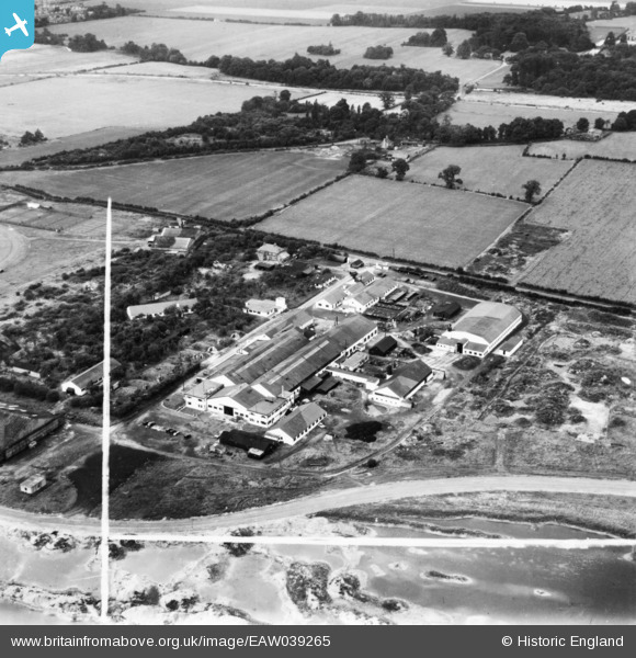
EAW039265 ENGLAND (1951). The Heston Aircraft Co Factory at Heston Airport, Hounslow, 1951. This image has been produced from a print marked by Aerofilms Ltd for photo editing.
© Copyright OpenStreetMap contributors and licensed by the OpenStreetMap Foundation. 2026. Cartography is licensed as CC BY-SA.
Nearby Images (23)
Details
| Title | [EAW039265] The Heston Aircraft Co Factory at Heston Airport, Hounslow, 1951. This image has been produced from a print marked by Aerofilms Ltd for photo editing. |
| Reference | EAW039265 |
| Date | 31-August-1951 |
| Link | |
| Place name | HOUNSLOW |
| Parish | |
| District | |
| Country | ENGLAND |
| Easting / Northing | 511067, 178176 |
| Longitude / Latitude | -0.40001535861006, 51.491123028476 |
| National Grid Reference | TQ111782 |
Pins

Matt Aldred edob.mattaldred.com |
Sunday 1st of August 2021 05:53:52 PM | |

Matt Aldred edob.mattaldred.com |
Sunday 1st of August 2021 05:50:38 PM |


![[EAW039265] The Heston Aircraft Co Factory at Heston Airport, Hounslow, 1951. This image has been produced from a print marked by Aerofilms Ltd for photo editing.](http://britainfromabove.org.uk/sites/all/libraries/aerofilms-images/public/100x100/EAW/039/EAW039265.jpg)
![[EAW039269] The Heston Aircraft Co Factory at Heston Airport, Hounslow, 1951. This image has been produced from a print marked by Aerofilms Ltd for photo editing.](http://britainfromabove.org.uk/sites/all/libraries/aerofilms-images/public/100x100/EAW/039/EAW039269.jpg)
![[EAW039273] The Heston Aircraft Co Factory at Heston Airport, Hounslow, 1951. This image has been produced from a print marked by Aerofilms Ltd for photo editing.](http://britainfromabove.org.uk/sites/all/libraries/aerofilms-images/public/100x100/EAW/039/EAW039273.jpg)
![[EAW039267] The Heston Aircraft Co Factory at Heston Airport, Hounslow, 1951. This image has been produced from a print marked by Aerofilms Ltd for photo editing.](http://britainfromabove.org.uk/sites/all/libraries/aerofilms-images/public/100x100/EAW/039/EAW039267.jpg)
![[EAW039272] The Heston Aircraft Co Factory at Heston Airport, Hounslow, from the south-west, 1951. This image has been produced from a print marked by Aerofilms Ltd for photo editing.](http://britainfromabove.org.uk/sites/all/libraries/aerofilms-images/public/100x100/EAW/039/EAW039272.jpg)
![[EAW039264] The Heston Aircraft Co Factory at Heston Airport, Hounslow, 1951. This image has been produced from a print marked by Aerofilms Ltd for photo editing.](http://britainfromabove.org.uk/sites/all/libraries/aerofilms-images/public/100x100/EAW/039/EAW039264.jpg)
![[EAW039268] The Heston Aircraft Co Factory at Heston Airport, Hounslow, 1951. This image has been produced from a print marked by Aerofilms Ltd for photo editing.](http://britainfromabove.org.uk/sites/all/libraries/aerofilms-images/public/100x100/EAW/039/EAW039268.jpg)
![[EPW043686] Comper Aircraft Company Workshop at Heston Aerodrome, Heston, 1933](http://britainfromabove.org.uk/sites/all/libraries/aerofilms-images/public/100x100/EPW/043/EPW043686.jpg)
![[EAW039270] The Heston Aircraft Co Factory at Heston Airport, Hounslow, from the west, 1951. This image has been produced from a print marked by Aerofilms Ltd for photo editing.](http://britainfromabove.org.uk/sites/all/libraries/aerofilms-images/public/100x100/EAW/039/EAW039270.jpg)
![[EPW044694] Comper Aircraft Company Workshop at Heston Aerodrome, Heston, 1934](http://britainfromabove.org.uk/sites/all/libraries/aerofilms-images/public/100x100/EPW/044/EPW044694.jpg)
![[EAW039266] The Heston Aircraft Co Factory at Heston Airport, Hounslow, 1951. This image has been produced from a print marked by Aerofilms Ltd for photo editing.](http://britainfromabove.org.uk/sites/all/libraries/aerofilms-images/public/100x100/EAW/039/EAW039266.jpg)
![[EPW043682] Comper Aircraft Company Workshop at Heston Aerodrome, Heston, 1933](http://britainfromabove.org.uk/sites/all/libraries/aerofilms-images/public/100x100/EPW/043/EPW043682.jpg)
![[EPW043681] Comper Aircraft Company Workshop at Heston Aerodrome, Heston, 1933](http://britainfromabove.org.uk/sites/all/libraries/aerofilms-images/public/100x100/EPW/043/EPW043681.jpg)
![[EPW043683] Comper Aircraft Company Workshop at Heston Aerodrome, Heston, 1933](http://britainfromabove.org.uk/sites/all/libraries/aerofilms-images/public/100x100/EPW/043/EPW043683.jpg)
![[EPW043685] Comper Aircraft Company Workshop at Heston Aerodrome, Heston, 1933](http://britainfromabove.org.uk/sites/all/libraries/aerofilms-images/public/100x100/EPW/043/EPW043685.jpg)
![[EAW039271] The Heston Aircraft Co Factory at Heston Airport, Hounslow, 1951. This image has been produced from a print marked by Aerofilms Ltd for photo editing.](http://britainfromabove.org.uk/sites/all/libraries/aerofilms-images/public/100x100/EAW/039/EAW039271.jpg)
![[EPR000459] The Gardens on Southall Lane, Heston, 1935](http://britainfromabove.org.uk/sites/all/libraries/aerofilms-images/public/100x100/EPR/000/EPR000459.jpg)
![[EPW043684] Comper Aircraft Company Workshop at Heston Aerodrome, Heston, 1933](http://britainfromabove.org.uk/sites/all/libraries/aerofilms-images/public/100x100/EPW/043/EPW043684.jpg)
![[EPW037337] Heston Airport, Heston, from the north-west, 1932](http://britainfromabove.org.uk/sites/all/libraries/aerofilms-images/public/100x100/EPW/037/EPW037337.jpg)
![[EPW044866] Lord Londonderry's Avro Cadet (possibly G-ACNY) after crash near Heston Aerodrome, Heston, 1934](http://britainfromabove.org.uk/sites/all/libraries/aerofilms-images/public/100x100/EPW/044/EPW044866.jpg)
![[EPW037988] Heston, aircraft lined up for the start of The Morning Post Cross-Country Air Race at Heston Aerodrome, from the north, 1932](http://britainfromabove.org.uk/sites/all/libraries/aerofilms-images/public/100x100/EPW/037/EPW037988.jpg)
![[EPW053978] Heston Aerodrome, Heston, from the north-west, 1937](http://britainfromabove.org.uk/sites/all/libraries/aerofilms-images/public/100x100/EPW/053/EPW053978.jpg)
![[EPW037987] Heston, aircraft lined up for the start of The Morning Post Cross-Country Air Race at Heston Aerodrome, 1932](http://britainfromabove.org.uk/sites/all/libraries/aerofilms-images/public/100x100/EPW/037/EPW037987.jpg)