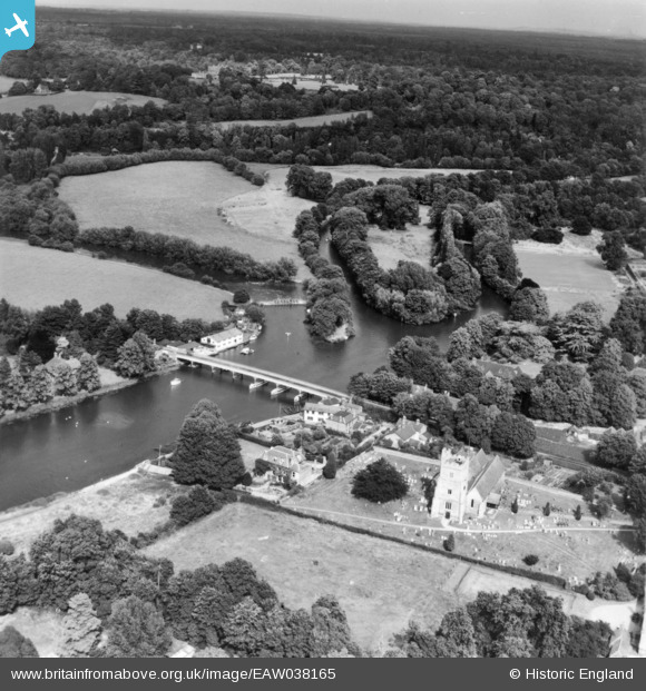
EAW038165 ENGLAND (1951). Holy Trinity Church, Cookham Bridge and the surrounding countryside, Cookham, from the west, 1951. This image has been produced from a print.
© Copyright OpenStreetMap contributors and licensed by the OpenStreetMap Foundation. 2025. Cartography is licensed as CC BY-SA.
Nearby Images (6)
Details
| Title | [EAW038165] Holy Trinity Church, Cookham Bridge and the surrounding countryside, Cookham, from the west, 1951. This image has been produced from a print. |
| Reference | EAW038165 |
| Date | 28-July-1951 |
| Link | |
| Place name | COOKHAM |
| Parish | COOKHAM |
| District | |
| Country | ENGLAND |
| Easting / Northing | 489695, 185561 |
| Longitude / Latitude | -0.70591604567007, 51.56131084568 |
| National Grid Reference | SU897856 |
Pins
Be the first to add a comment to this image!


![[EAW038165] Holy Trinity Church, Cookham Bridge and the surrounding countryside, Cookham, from the west, 1951. This image has been produced from a print.](http://britainfromabove.org.uk/sites/all/libraries/aerofilms-images/public/100x100/EAW/038/EAW038165.jpg)
![[EPW052601] The River Thames, Cookham, from the south-east, 1937. This image has been produced from a copy-negative.](http://britainfromabove.org.uk/sites/all/libraries/aerofilms-images/public/100x100/EPW/052/EPW052601.jpg)
![[EAW038164] Housing off Riversdale and the surrounding countryside, Bourne End, from the south-east, 1951. This image has been produced from a print.](http://britainfromabove.org.uk/sites/all/libraries/aerofilms-images/public/100x100/EAW/038/EAW038164.jpg)
![[EAW034763] The River Thames in flood by River Cottage, Riverdene and Cock Marsh, Bourne End, 1951](http://britainfromabove.org.uk/sites/all/libraries/aerofilms-images/public/100x100/EAW/034/EAW034763.jpg)
![[EAW034767] Cookham Bridge and the River Thames in flood, Bourne End, 1951](http://britainfromabove.org.uk/sites/all/libraries/aerofilms-images/public/100x100/EAW/034/EAW034767.jpg)
![[EAW003668] Flooding at Cookham Moor, Cookham, 1947](http://britainfromabove.org.uk/sites/all/libraries/aerofilms-images/public/100x100/EAW/003/EAW003668.jpg)