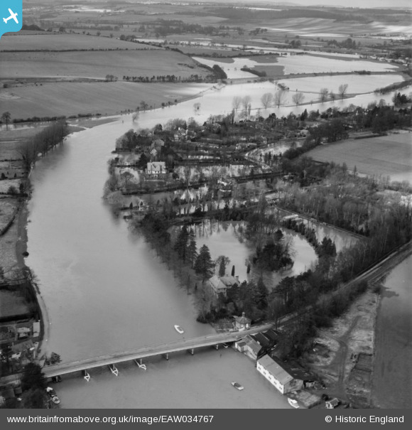
EAW034767 ENGLAND (1951). Cookham Bridge and the River Thames in flood, Bourne End, 1951
© Copyright OpenStreetMap contributors and licensed by the OpenStreetMap Foundation. 2025. Cartography is licensed as CC BY-SA.
Nearby Images (11)
Details
| Title | [EAW034767] Cookham Bridge and the River Thames in flood, Bourne End, 1951 |
| Reference | EAW034767 |
| Date | 22-February-1951 |
| Link | |
| Place name | BOURNE END |
| Parish | WOOBURN |
| District | |
| Country | ENGLAND |
| Easting / Northing | 489660, 185792 |
| Longitude / Latitude | -0.70636193855576, 51.56339312916 |
| National Grid Reference | SU897858 |
Pins
Be the first to add a comment to this image!


![[EAW034767] Cookham Bridge and the River Thames in flood, Bourne End, 1951](http://britainfromabove.org.uk/sites/all/libraries/aerofilms-images/public/100x100/EAW/034/EAW034767.jpg)
![[EAW034763] The River Thames in flood by River Cottage, Riverdene and Cock Marsh, Bourne End, 1951](http://britainfromabove.org.uk/sites/all/libraries/aerofilms-images/public/100x100/EAW/034/EAW034763.jpg)
![[EAW003830] Flooding around Ferry Lane, Bourne End, from the west, 1947](http://britainfromabove.org.uk/sites/all/libraries/aerofilms-images/public/100x100/EAW/003/EAW003830.jpg)
![[EAW038164] Housing off Riversdale and the surrounding countryside, Bourne End, from the south-east, 1951. This image has been produced from a print.](http://britainfromabove.org.uk/sites/all/libraries/aerofilms-images/public/100x100/EAW/038/EAW038164.jpg)
![[EPW052582] Cookham, the River Thames, Ferry Lane and environs, Bourne End, 1937. This image has been produced from a copy-negative.](http://britainfromabove.org.uk/sites/all/libraries/aerofilms-images/public/100x100/EPW/052/EPW052582.jpg)
![[EAW034761] The River Thames in flood by Waterside and Strangers, Bourne End, 1951](http://britainfromabove.org.uk/sites/all/libraries/aerofilms-images/public/100x100/EAW/034/EAW034761.jpg)
![[EAW034766] The River Thames in flood by Waterside and Strangers, Bourne End, 1951](http://britainfromabove.org.uk/sites/all/libraries/aerofilms-images/public/100x100/EAW/034/EAW034766.jpg)
![[EAW034765] The River Thames in flood by Waterside and Strangers, Bourne End, 1951](http://britainfromabove.org.uk/sites/all/libraries/aerofilms-images/public/100x100/EAW/034/EAW034765.jpg)
![[EPW052601] The River Thames, Cookham, from the south-east, 1937. This image has been produced from a copy-negative.](http://britainfromabove.org.uk/sites/all/libraries/aerofilms-images/public/100x100/EPW/052/EPW052601.jpg)
![[EAW038165] Holy Trinity Church, Cookham Bridge and the surrounding countryside, Cookham, from the west, 1951. This image has been produced from a print.](http://britainfromabove.org.uk/sites/all/libraries/aerofilms-images/public/100x100/EAW/038/EAW038165.jpg)
![[EAW034762] Orchard Dene, Bourne End, 1951](http://britainfromabove.org.uk/sites/all/libraries/aerofilms-images/public/100x100/EAW/034/EAW034762.jpg)