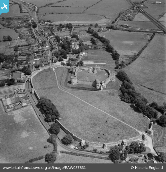
EAW037831 ENGLAND (1951). Pevensey Castle, Pevensey, 1951
© Copyright OpenStreetMap contributors and licensed by the OpenStreetMap Foundation. 2026. Cartography is licensed as CC BY-SA.
Nearby Images (17)
Details
| Title | [EAW037831] Pevensey Castle, Pevensey, 1951 |
| Reference | EAW037831 |
| Date | 17-July-1951 |
| Link | |
| Place name | PEVENSEY |
| Parish | PEVENSEY |
| District | |
| Country | ENGLAND |
| Easting / Northing | 564484, 104791 |
| Longitude / Latitude | 0.33535823696404, 50.818709608633 |
| National Grid Reference | TQ645048 |
Pins

redmist |
Saturday 9th of April 2022 10:43:38 PM | |

redmist |
Saturday 9th of April 2022 10:40:51 PM | |

redmist |
Saturday 9th of April 2022 10:34:35 PM | |

Alan McFaden |
Saturday 26th of April 2014 06:13:58 PM | |

Alan McFaden |
Saturday 26th of April 2014 06:13:06 PM | |

Alan McFaden |
Saturday 26th of April 2014 06:12:02 PM | |

Alan McFaden |
Saturday 26th of April 2014 06:10:46 PM | |

Alan McFaden |
Saturday 26th of April 2014 06:09:54 PM | |

Alan McFaden |
Saturday 26th of April 2014 06:09:21 PM |


![[EAW037831] Pevensey Castle, Pevensey, 1951](http://britainfromabove.org.uk/sites/all/libraries/aerofilms-images/public/100x100/EAW/037/EAW037831.jpg)
![[EPW051356] Pevensey Castle, Pevensey, 1936](http://britainfromabove.org.uk/sites/all/libraries/aerofilms-images/public/100x100/EPW/051/EPW051356.jpg)
![[EAW037830] Pevensey Castle, Pevensey, 1951. This image has been produced from a damaged negative.](http://britainfromabove.org.uk/sites/all/libraries/aerofilms-images/public/100x100/EAW/037/EAW037830.jpg)
![[EPW051350] Pevensey Castle, Pevensey, 1936](http://britainfromabove.org.uk/sites/all/libraries/aerofilms-images/public/100x100/EPW/051/EPW051350.jpg)
![[EAW014354] Pevensey Castle, Pevensey, 1948. This image has been produced from a print.](http://britainfromabove.org.uk/sites/all/libraries/aerofilms-images/public/100x100/EAW/014/EAW014354.jpg)
![[EPW035328] Pevensey Castle under repair amd the village, Pevensey, 1931](http://britainfromabove.org.uk/sites/all/libraries/aerofilms-images/public/100x100/EPW/035/EPW035328.jpg)
![[EAW014356] Pevensey Castle, Pevensey, 1948. This image has been produced from a print.](http://britainfromabove.org.uk/sites/all/libraries/aerofilms-images/public/100x100/EAW/014/EAW014356.jpg)
![[EAW014358] Pevensey Castle, Pevensey, from the south-west, 1948. This image has been produced from a print.](http://britainfromabove.org.uk/sites/all/libraries/aerofilms-images/public/100x100/EAW/014/EAW014358.jpg)
![[EAW014357] Pevensey Castle, Pevensey, 1948. This image has been produced from a print.](http://britainfromabove.org.uk/sites/all/libraries/aerofilms-images/public/100x100/EAW/014/EAW014357.jpg)
![[EAW014355] Pevensey Castle, Pevensey, 1948. This image has been produced from a print.](http://britainfromabove.org.uk/sites/all/libraries/aerofilms-images/public/100x100/EAW/014/EAW014355.jpg)
![[EPW051353] Pevensey Castle, Pevensey, 1936](http://britainfromabove.org.uk/sites/all/libraries/aerofilms-images/public/100x100/EPW/051/EPW051353.jpg)
![[EAW014353] Pevensey Castle, Pevensey, 1948. This image has been produced from a print.](http://britainfromabove.org.uk/sites/all/libraries/aerofilms-images/public/100x100/EAW/014/EAW014353.jpg)
![[EPW051351] Pevensey Castle, Pevensey, 1936](http://britainfromabove.org.uk/sites/all/libraries/aerofilms-images/public/100x100/EPW/051/EPW051351.jpg)
![[EPW035326] Pevensey village and castle, Pevensey, 1931](http://britainfromabove.org.uk/sites/all/libraries/aerofilms-images/public/100x100/EPW/035/EPW035326.jpg)
![[EPW051349] Pevensey Castle, Pevensey, 1936](http://britainfromabove.org.uk/sites/all/libraries/aerofilms-images/public/100x100/EPW/051/EPW051349.jpg)
![[EPW035325] Pevensey Castle and environs, Pevensey, 1931](http://britainfromabove.org.uk/sites/all/libraries/aerofilms-images/public/100x100/EPW/035/EPW035325.jpg)
![[EPW051354] Pevensey Castle and St Mary's Church Westham, Pevensey, 1936](http://britainfromabove.org.uk/sites/all/libraries/aerofilms-images/public/100x100/EPW/051/EPW051354.jpg)


