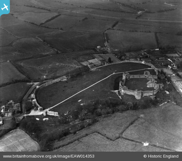
EAW014353 ENGLAND (1948). Pevensey Castle, Pevensey, 1948. This image has been produced from a print.
© Copyright OpenStreetMap contributors and licensed by the OpenStreetMap Foundation. 2026. Cartography is licensed as CC BY-SA.
Nearby Images (18)
Details
| Title | [EAW014353] Pevensey Castle, Pevensey, 1948. This image has been produced from a print. |
| Reference | EAW014353 |
| Date | 13-April-1948 |
| Link | |
| Place name | PEVENSEY |
| Parish | PEVENSEY |
| District | |
| Country | ENGLAND |
| Easting / Northing | 564418, 104828 |
| Longitude / Latitude | 0.33443857964667, 50.819060838772 |
| National Grid Reference | TQ644048 |
Pins

redmist |
Saturday 9th of April 2022 10:55:02 PM | |

redmist |
Saturday 9th of April 2022 10:49:25 PM | |

redmist |
Saturday 9th of April 2022 10:48:32 PM | |

redmist |
Saturday 9th of April 2022 10:47:22 PM | |

redmist |
Saturday 9th of April 2022 10:46:49 PM | |

redmist |
Saturday 9th of April 2022 10:46:09 PM | |

cptpies |
Monday 6th of July 2020 09:06:57 AM | |

Alan McFaden |
Friday 24th of October 2014 09:19:21 AM | |

Alan McFaden |
Friday 24th of October 2014 09:18:28 AM |
User Comment Contributions

Pevensey Castle Ruin |

Alan McFaden |
Friday 24th of October 2014 09:20:22 AM |


![[EAW014353] Pevensey Castle, Pevensey, 1948. This image has been produced from a print.](http://britainfromabove.org.uk/sites/all/libraries/aerofilms-images/public/100x100/EAW/014/EAW014353.jpg)
![[EPW051353] Pevensey Castle, Pevensey, 1936](http://britainfromabove.org.uk/sites/all/libraries/aerofilms-images/public/100x100/EPW/051/EPW051353.jpg)
![[EPW051351] Pevensey Castle, Pevensey, 1936](http://britainfromabove.org.uk/sites/all/libraries/aerofilms-images/public/100x100/EPW/051/EPW051351.jpg)
![[EAW037830] Pevensey Castle, Pevensey, 1951. This image has been produced from a damaged negative.](http://britainfromabove.org.uk/sites/all/libraries/aerofilms-images/public/100x100/EAW/037/EAW037830.jpg)
![[EPW051356] Pevensey Castle, Pevensey, 1936](http://britainfromabove.org.uk/sites/all/libraries/aerofilms-images/public/100x100/EPW/051/EPW051356.jpg)
![[EPW035328] Pevensey Castle under repair amd the village, Pevensey, 1931](http://britainfromabove.org.uk/sites/all/libraries/aerofilms-images/public/100x100/EPW/035/EPW035328.jpg)
![[EAW037831] Pevensey Castle, Pevensey, 1951](http://britainfromabove.org.uk/sites/all/libraries/aerofilms-images/public/100x100/EAW/037/EAW037831.jpg)
![[EPW051350] Pevensey Castle, Pevensey, 1936](http://britainfromabove.org.uk/sites/all/libraries/aerofilms-images/public/100x100/EPW/051/EPW051350.jpg)
![[EAW014354] Pevensey Castle, Pevensey, 1948. This image has been produced from a print.](http://britainfromabove.org.uk/sites/all/libraries/aerofilms-images/public/100x100/EAW/014/EAW014354.jpg)
![[EAW014356] Pevensey Castle, Pevensey, 1948. This image has been produced from a print.](http://britainfromabove.org.uk/sites/all/libraries/aerofilms-images/public/100x100/EAW/014/EAW014356.jpg)
![[EPW051349] Pevensey Castle, Pevensey, 1936](http://britainfromabove.org.uk/sites/all/libraries/aerofilms-images/public/100x100/EPW/051/EPW051349.jpg)
![[EAW014358] Pevensey Castle, Pevensey, from the south-west, 1948. This image has been produced from a print.](http://britainfromabove.org.uk/sites/all/libraries/aerofilms-images/public/100x100/EAW/014/EAW014358.jpg)
![[EAW014357] Pevensey Castle, Pevensey, 1948. This image has been produced from a print.](http://britainfromabove.org.uk/sites/all/libraries/aerofilms-images/public/100x100/EAW/014/EAW014357.jpg)
![[EAW014355] Pevensey Castle, Pevensey, 1948. This image has been produced from a print.](http://britainfromabove.org.uk/sites/all/libraries/aerofilms-images/public/100x100/EAW/014/EAW014355.jpg)
![[EPW051354] Pevensey Castle and St Mary's Church Westham, Pevensey, 1936](http://britainfromabove.org.uk/sites/all/libraries/aerofilms-images/public/100x100/EPW/051/EPW051354.jpg)
![[EPW035325] Pevensey Castle and environs, Pevensey, 1931](http://britainfromabove.org.uk/sites/all/libraries/aerofilms-images/public/100x100/EPW/035/EPW035325.jpg)
![[EPW035326] Pevensey village and castle, Pevensey, 1931](http://britainfromabove.org.uk/sites/all/libraries/aerofilms-images/public/100x100/EPW/035/EPW035326.jpg)
![[EPW051352] Westham village and Pevensey Castle, Westham, 1936](http://britainfromabove.org.uk/sites/all/libraries/aerofilms-images/public/100x100/EPW/051/EPW051352.jpg)

