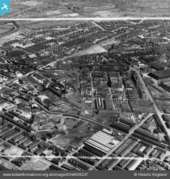
EAW036137 ENGLAND (1951). The Clayton Aniline Chemical Works and environs, Manchester, 1951. This image has been produced from a print marked by Aerofilms Ltd for photo editing.
© Copyright OpenStreetMap contributors and licensed by the OpenStreetMap Foundation. 2026. Cartography is licensed as CC BY-SA.
Nearby Images (9)
Details
| Title | [EAW036137] The Clayton Aniline Chemical Works and environs, Manchester, 1951. This image has been produced from a print marked by Aerofilms Ltd for photo editing. |
| Reference | EAW036137 |
| Date | 17-May-1951 |
| Link | |
| Place name | MANCHESTER |
| Parish | |
| District | |
| Country | ENGLAND |
| Easting / Northing | 387563, 398188 |
| Longitude / Latitude | -2.1874248390014, 53.480016079452 |
| National Grid Reference | SJ876982 |
Pins

wriggleruk |
Monday 19th of February 2024 09:08:35 PM | |

redmist |
Saturday 10th of October 2020 11:54:58 AM | |

Barney Rubble |
Friday 1st of March 2019 02:35:28 PM | |

Barney Rubble |
Friday 1st of March 2019 02:21:45 PM | |

J.Smith |
Saturday 12th of January 2019 09:19:12 PM | |

Barney Rubble |
Wednesday 7th of January 2015 05:54:29 PM | |

Barney Rubble |
Wednesday 7th of January 2015 05:50:00 PM | |

Barney Rubble |
Wednesday 7th of January 2015 05:49:34 PM | |

Barney Rubble |
Wednesday 7th of January 2015 05:48:23 PM | |

Barney Rubble |
Wednesday 7th of January 2015 05:46:30 PM |


![[EAW036137] The Clayton Aniline Chemical Works and environs, Manchester, 1951. This image has been produced from a print marked by Aerofilms Ltd for photo editing.](http://britainfromabove.org.uk/sites/all/libraries/aerofilms-images/public/100x100/EAW/036/EAW036137.jpg)
![[EAW036135] The Clayton Aniline Chemical Works and environs, Manchester, 1951. This image has been produced from a print marked by Aerofilms Ltd for photo editing.](http://britainfromabove.org.uk/sites/all/libraries/aerofilms-images/public/100x100/EAW/036/EAW036135.jpg)
![[EAW036138] The Clayton Aniline Chemical Works and environs, Manchester, 1951. This image has been produced from a print marked by Aerofilms Ltd for photo editing.](http://britainfromabove.org.uk/sites/all/libraries/aerofilms-images/public/100x100/EAW/036/EAW036138.jpg)
![[EAW036134] The Clayton Aniline Chemical Works and environs, Manchester, 1951. This image has been produced from a print marked by Aerofilms Ltd for photo editing.](http://britainfromabove.org.uk/sites/all/libraries/aerofilms-images/public/100x100/EAW/036/EAW036134.jpg)
![[EAW036129] The Clayton Aniline Chemical Works and environs, Manchester, 1951. This image has been produced from a print marked by Aerofilms Ltd for photo editing.](http://britainfromabove.org.uk/sites/all/libraries/aerofilms-images/public/100x100/EAW/036/EAW036129.jpg)
![[EAW036133] The Clayton Aniline Chemical Works and environs, Manchester, 1951. This image has been produced from a print marked by Aerofilms Ltd for photo editing.](http://britainfromabove.org.uk/sites/all/libraries/aerofilms-images/public/100x100/EAW/036/EAW036133.jpg)
![[EAW036131] The Clayton Aniline Chemical Works and environs, Manchester, 1951. This image has been produced from a print marked by Aerofilms Ltd for photo editing.](http://britainfromabove.org.uk/sites/all/libraries/aerofilms-images/public/100x100/EAW/036/EAW036131.jpg)
![[EAW036130] The Clayton Aniline Chemical Works and environs, Manchester, 1951. This image has been produced from a print marked by Aerofilms Ltd for photo editing.](http://britainfromabove.org.uk/sites/all/libraries/aerofilms-images/public/100x100/EAW/036/EAW036130.jpg)
![[EAW036132] The Clayton Aniline Chemical Works and environs, Manchester, 1951. This image has been produced from a print marked by Aerofilms Ltd for photo editing.](http://britainfromabove.org.uk/sites/all/libraries/aerofilms-images/public/100x100/EAW/036/EAW036132.jpg)
