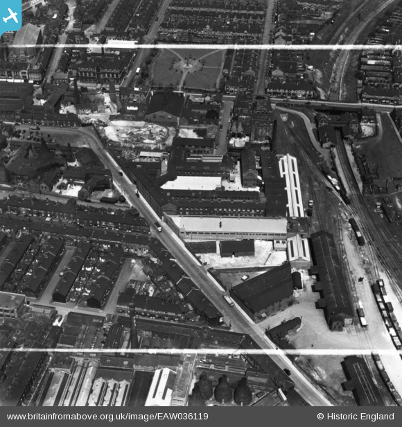
EAW036119 ENGLAND (1951). The Alexandra Pottery (Earthenware), Tunstall, 1951. This image has been produced from a print marked by Aerofilms Ltd for photo editing.
© Copyright OpenStreetMap contributors and licensed by the OpenStreetMap Foundation. 2026. Cartography is licensed as CC BY-SA.
Nearby Images (42)
Details
| Title | [EAW036119] The Alexandra Pottery (Earthenware), Tunstall, 1951. This image has been produced from a print marked by Aerofilms Ltd for photo editing. |
| Reference | EAW036119 |
| Date | 18-May-1951 |
| Link | |
| Place name | TUNSTALL |
| Parish | |
| District | |
| Country | ENGLAND |
| Easting / Northing | 386222, 351164 |
| Longitude / Latitude | -2.2055955320726, 53.057248556389 |
| National Grid Reference | SJ862512 |
Pins
Be the first to add a comment to this image!


![[EAW036119] The Alexandra Pottery (Earthenware), Tunstall, 1951. This image has been produced from a print marked by Aerofilms Ltd for photo editing.](http://britainfromabove.org.uk/sites/all/libraries/aerofilms-images/public/100x100/EAW/036/EAW036119.jpg)
![[EAW036121] The Alexandra Pottery (Earthenware), Tunstall, 1951. This image has been produced from a print marked by Aerofilms Ltd for photo editing.](http://britainfromabove.org.uk/sites/all/libraries/aerofilms-images/public/100x100/EAW/036/EAW036121.jpg)
![[EAW036120] The Alexandra Pottery (Earthenware), Tunstall, 1951. This image has been produced from a print marked by Aerofilms Ltd for photo editing.](http://britainfromabove.org.uk/sites/all/libraries/aerofilms-images/public/100x100/EAW/036/EAW036120.jpg)
![[EAW036117] The Alexandra Pottery (Earthenware), Tunstall, 1951. This image has been produced from a print marked by Aerofilms Ltd for photo editing.](http://britainfromabove.org.uk/sites/all/libraries/aerofilms-images/public/100x100/EAW/036/EAW036117.jpg)
![[EAW036116] The Alexandra Pottery (Earthenware), Tunstall, 1951. This image has been produced from a print marked by Aerofilms Ltd for photo editing.](http://britainfromabove.org.uk/sites/all/libraries/aerofilms-images/public/100x100/EAW/036/EAW036116.jpg)
![[EAW036115] The Alexandra Pottery (Earthenware), Tunstall, 1951. This image has been produced from a print marked by Aerofilms Ltd for photo editing.](http://britainfromabove.org.uk/sites/all/libraries/aerofilms-images/public/100x100/EAW/036/EAW036115.jpg)
![[EAW036118] The Alexandra Pottery (Earthenware), Tunstall, 1951. This image has been produced from a print marked by Aerofilms Ltd for photo editing.](http://britainfromabove.org.uk/sites/all/libraries/aerofilms-images/public/100x100/EAW/036/EAW036118.jpg)
![[EAW036114] The Alexandra Pottery (Earthenware), Tunstall, 1951. This image has been produced from a print marked by Aerofilms Ltd for photo editing.](http://britainfromabove.org.uk/sites/all/libraries/aerofilms-images/public/100x100/EAW/036/EAW036114.jpg)
![[EAW027951] The Richards Tiles Ltd Pinnox Tile Works and environs, Tunstall, 1950](http://britainfromabove.org.uk/sites/all/libraries/aerofilms-images/public/100x100/EAW/027/EAW027951.jpg)
![[EAW027953] The Richards Tiles Ltd Pinnox Tile Works, Tunstall, 1950. This image was marked by Aerofilms Ltd for photo editing.](http://britainfromabove.org.uk/sites/all/libraries/aerofilms-images/public/100x100/EAW/027/EAW027953.jpg)
![[EPW047614] The Pinnox Tile Works and environs, Tunstall, 1935](http://britainfromabove.org.uk/sites/all/libraries/aerofilms-images/public/100x100/EPW/047/EPW047614.jpg)
![[EPW017310] The Pinnox Tile Works on Scotia Road, Tunstall, 1926](http://britainfromabove.org.uk/sites/all/libraries/aerofilms-images/public/100x100/EPW/017/EPW017310.jpg)
![[EAW028358] The Richards Tiles Ltd Pinnox Tile Works, Woodland Pottery and environs, Tunstall, 1950. This image was marked by Aerofilms Ltd for photo editing.](http://britainfromabove.org.uk/sites/all/libraries/aerofilms-images/public/100x100/EAW/028/EAW028358.jpg)
![[EPW017312] The Pinnox Tile Works on Scotia Road, Tunstall, 1926](http://britainfromabove.org.uk/sites/all/libraries/aerofilms-images/public/100x100/EPW/017/EPW017312.jpg)
![[EPW017315] The Pinnox Tile Works on Scotia Road, Tunstall, 1926](http://britainfromabove.org.uk/sites/all/libraries/aerofilms-images/public/100x100/EPW/017/EPW017315.jpg)
![[EPW047613] The Pinnox Tile Works and environs, Tunstall, 1935](http://britainfromabove.org.uk/sites/all/libraries/aerofilms-images/public/100x100/EPW/047/EPW047613.jpg)
![[EAW027950] The Richards Tiles Ltd Pinnox Tile Works, Tunstall, 1950](http://britainfromabove.org.uk/sites/all/libraries/aerofilms-images/public/100x100/EAW/027/EAW027950.jpg)
![[EPW017311] The Pinnox Tile Works on Scotia Road, Tunstall, 1926](http://britainfromabove.org.uk/sites/all/libraries/aerofilms-images/public/100x100/EPW/017/EPW017311.jpg)
![[EAW027954] The Richards Tiles Ltd Pinnox Tile Works and environs, Tunstall, 1950. This image was marked by Aerofilms Ltd for photo editing.](http://britainfromabove.org.uk/sites/all/libraries/aerofilms-images/public/100x100/EAW/027/EAW027954.jpg)
![[EAW027952] The Richards Tiles Ltd Pinnox Tile Works, Tunstall, 1950](http://britainfromabove.org.uk/sites/all/libraries/aerofilms-images/public/100x100/EAW/027/EAW027952.jpg)
![[EAW028359] The Richards Tiles Ltd Pinnox Tile Works and environs, Tunstall, 1950](http://britainfromabove.org.uk/sites/all/libraries/aerofilms-images/public/100x100/EAW/028/EAW028359.jpg)
![[EAW027948] The Richards Tiles Ltd Pinnox Tile Works, Tunstall, 1950. This image has been produced from a print marked by Aerofilms Ltd for photo editing.](http://britainfromabove.org.uk/sites/all/libraries/aerofilms-images/public/100x100/EAW/027/EAW027948.jpg)
![[EAW028355] The Richards Tiles Ltd Pinnox Tile Works (site of), Tunstall, 1950. This image has been produced from a damaged negative.](http://britainfromabove.org.uk/sites/all/libraries/aerofilms-images/public/100x100/EAW/028/EAW028355.jpg)
![[EPW017314] The Pinnox Tile Works on Scotia Road, Tunstall, 1926. This image is partially obscured as a result of flare](http://britainfromabove.org.uk/sites/all/libraries/aerofilms-images/public/100x100/EPW/017/EPW017314.jpg)
![[EPW017309] The Pinnox Tile Works on Scotia Road, Tunstall, 1926](http://britainfromabove.org.uk/sites/all/libraries/aerofilms-images/public/100x100/EPW/017/EPW017309.jpg)
![[EPW017313] The Pinnox Tile Works on Scotia Road, Tunstall, 1926](http://britainfromabove.org.uk/sites/all/libraries/aerofilms-images/public/100x100/EPW/017/EPW017313.jpg)
![[EPW047610] The Pinnox Tile Works and environs, Tunstall, 1935](http://britainfromabove.org.uk/sites/all/libraries/aerofilms-images/public/100x100/EPW/047/EPW047610.jpg)
![[EPW047611] The Pinnox Tile Works and environs, Tunstall, 1935](http://britainfromabove.org.uk/sites/all/libraries/aerofilms-images/public/100x100/EPW/047/EPW047611.jpg)
![[EAW028357] The Richards Tiles Ltd Pinnox Tile Works and environs, Tunstall, 1950. This image was marked by Aerofilms Ltd for photo editing.](http://britainfromabove.org.uk/sites/all/libraries/aerofilms-images/public/100x100/EAW/028/EAW028357.jpg)
![[EAW027949] The Richards Tiles Ltd Pinnox Tile Works, Tunstall, 1950. This image has been produced from a print marked by Aerofilms Ltd for photo editing.](http://britainfromabove.org.uk/sites/all/libraries/aerofilms-images/public/100x100/EAW/027/EAW027949.jpg)
![[EAW028354] The Richards Tiles Ltd Pinnox Tile Works (site of), Tunstall, 1950. This image has been produced from a damaged negative.](http://britainfromabove.org.uk/sites/all/libraries/aerofilms-images/public/100x100/EAW/028/EAW028354.jpg)
![[EAW028356] The Richards Tiles Ltd Pinnox Tile Works and environs, Tunstall, 1950. This image has been produced from a damaged negative.](http://britainfromabove.org.uk/sites/all/libraries/aerofilms-images/public/100x100/EAW/028/EAW028356.jpg)
![[EPW047615] The Pinnox Tile Works and environs, Tunstall, 1935](http://britainfromabove.org.uk/sites/all/libraries/aerofilms-images/public/100x100/EPW/047/EPW047615.jpg)
![[EPW047612] The Pinnox Tile Works and environs, Tunstall, 1935](http://britainfromabove.org.uk/sites/all/libraries/aerofilms-images/public/100x100/EPW/047/EPW047612.jpg)
![[EPW054085] The High Street by High Street School, Tunstall, 1937](http://britainfromabove.org.uk/sites/all/libraries/aerofilms-images/public/100x100/EPW/054/EPW054085.jpg)
![[EPW047609] The Pinnox Tile Works and environs, Tunstall, 1935](http://britainfromabove.org.uk/sites/all/libraries/aerofilms-images/public/100x100/EPW/047/EPW047609.jpg)
![[EPW054091] The High Street, Tunstall, 1937](http://britainfromabove.org.uk/sites/all/libraries/aerofilms-images/public/100x100/EPW/054/EPW054091.jpg)
![[EPW054084] The Market Square and Clock Tower, Tunstall, 1937](http://britainfromabove.org.uk/sites/all/libraries/aerofilms-images/public/100x100/EPW/054/EPW054084.jpg)
![[EAW036190] Sacred Heart Roman Catholic Church and part of Victoria Park, Tunstall, 1951. This image has been produced from a print.](http://britainfromabove.org.uk/sites/all/libraries/aerofilms-images/public/100x100/EAW/036/EAW036190.jpg)
![[EPW054087] High Street School and Sneyd Street, Tunstall, 1937](http://britainfromabove.org.uk/sites/all/libraries/aerofilms-images/public/100x100/EPW/054/EPW054087.jpg)
![[EPW054086] The Swan Pottery, Ritz Cinema and High Street, Tunstall, 1937](http://britainfromabove.org.uk/sites/all/libraries/aerofilms-images/public/100x100/EPW/054/EPW054086.jpg)
![[EPW054083] The Ritz Cinema and High Street, Tunstall, 1937](http://britainfromabove.org.uk/sites/all/libraries/aerofilms-images/public/100x100/EPW/054/EPW054083.jpg)