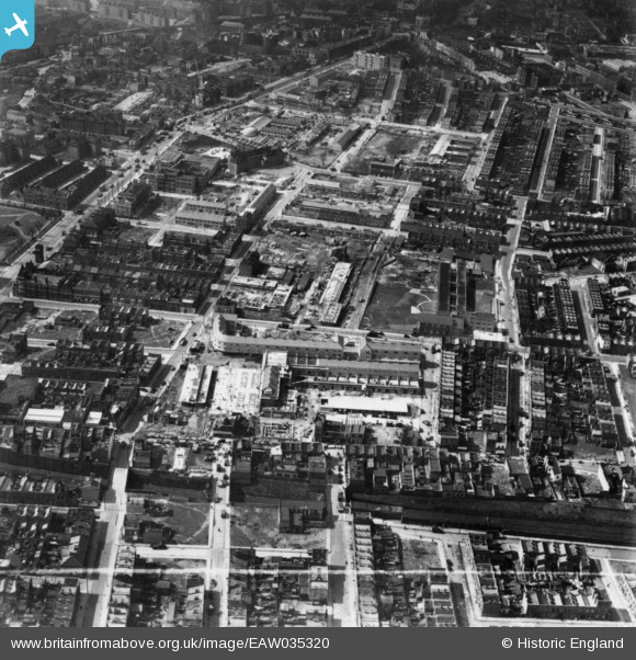
EAW035320 ENGLAND (1951). Market Square, Ricardo Street and environs, Poplar, 1951. This image has been produced from a print marked by Aerofilms Ltd for photo editing.
    © Copyright OpenStreetMap contributors and licensed by the OpenStreetMap Foundation. 2025. Cartography is licensed as CC BY-SA.
  
Nearby Images (6)
Details
| Title | [EAW035320] Market Square, Ricardo Street and environs, Poplar, 1951. This image has been produced from a print marked by Aerofilms Ltd for photo editing. | 
| Reference | EAW035320 | 
| Date | 10-April-1951 | 
| Link | |
| Place name | POPLAR | 
| Parish | |
| District | |
| Country | ENGLAND | 
| Easting / Northing | 537760, 181185 | 
| Longitude / Latitude | -0.014536080044726, 51.512291264255 | 
| National Grid Reference | TQ378812 | 
Pins
|  Market House Tavern at 7 Ricardo Street, in the centre of Randalls Market which ran north-south between Grundy Street to the south and Market Street to the north. |   Chaz | Tuesday 10th of June 2025 11:08:47 PM | 
|  Offices of the Guardians of Poplar Union workhouse |   Chaz | Tuesday 10th of June 2025 09:11:20 PM | 
|  Heckford House |   Chaz | Tuesday 10th of June 2025 09:04:40 PM | 
|  Prince Of Wales, a Beer House, replace for the Festival of Britain in in 1951. Originally 61 Chrisp Street, the replacement was number 55, it was still open as "Callaghans" at the time of Writing. |   Leslie B | Thursday 7th of July 2022 02:55:56 PM | 
|  The Young Prince, a Whitbread Public House, replace in the 1960s by a modern building, that closed in the late 2000s. |   Leslie B | Thursday 7th of July 2022 02:48:51 PM | 
|  Duke of Clarence, Public House. Long demolished. |   Leslie B | Thursday 7th of July 2022 02:41:06 PM | 
|  The East London Stores (28 Chrisp Street), was a Taylor Walker Beer House. It was demolished in the 1950s. |   Leslie B | Thursday 7th of July 2022 02:31:27 PM | 
|  This was the Site of the Grundy Arms, A Truman House. It was still open in 1947. |   Leslie B | Thursday 7th of July 2022 02:26:47 PM | 
|  The Enterprise, was a Beer House at 69 Grundy Street, corner of Kerbey Street when Grundy Street ran on beyond here to Crisp Street, all long Demolished. The Festival Inn is on a similar spot to the Enterprise. |   Leslie B | Thursday 7th of July 2022 02:24:35 PM | 
|  Ricardo Street |   Robin | Saturday 29th of June 2019 12:50:15 AM | 
|  The Africa Tavern pub |   Robin | Saturday 29th of June 2019 12:40:22 AM | 
|  The monogram above the front door on this bank building at 660 East India Dock Road says "LJSB" -- the London Joint Stock Bank. |   Robin | Saturday 29th of June 2019 12:21:57 AM | 
|  Manor Arms pub |   Robin | Saturday 29th of June 2019 12:11:53 AM | 
|  Pigott Street |   Robin | Friday 28th of June 2019 11:53:10 PM | 
|  Prefabs on Stainsby Road |   Robin | Friday 28th of June 2019 11:43:19 PM | 
|  Chrisp Street |   Robin | Friday 28th of June 2019 11:19:16 PM | 
|  Grundy Street |   Robin | Friday 28th of June 2019 11:05:27 PM | 
|  Canton Street |   Robin | Friday 28th of June 2019 11:03:49 PM | 
|  Hale Street |   Robin | Friday 28th of June 2019 10:59:43 PM | 
|  East India Dock Road |   Robin | Friday 28th of June 2019 10:55:36 PM | 
|  St Anne's Limehouse |   Robin | Friday 28th of June 2019 10:54:55 PM | 
|  Burcham Street.
Was Stock Street on an 1885 map. |   jandpatupton | Monday 6th of October 2014 04:08:40 PM | 
 
             
  ![[EAW035320] Market Square, Ricardo Street and environs, Poplar, 1951. This image has been produced from a print marked by Aerofilms Ltd for photo editing.](http://britainfromabove.org.uk/sites/all/libraries/aerofilms-images/public/100x100/EAW/035/EAW035320.jpg) 
  
                                          ![[EAW035316] Kerbey Street and environs, Poplar, 1951. This image has been produced from a print.](http://britainfromabove.org.uk/sites/all/libraries/aerofilms-images/public/100x100/EAW/035/EAW035316.jpg) 
 ![[EAW035317] East India Dock Road, Kerbey Street and environs, Poplar, 1951. This image has been produced from a print marked by Aerofilms Ltd for photo editing.](http://britainfromabove.org.uk/sites/all/libraries/aerofilms-images/public/100x100/EAW/035/EAW035317.jpg) 
 ![[EAW035318] All Saints Church, Chrisp Street and environs, Poplar, 1951. This image has been produced from a print marked by Aerofilms Ltd for photo editing.](http://britainfromabove.org.uk/sites/all/libraries/aerofilms-images/public/100x100/EAW/035/EAW035318.jpg) 
 ![[EAW035319] Ida Street, Chrisp Street and environs, Poplar, 1951. This image has been produced from a print.](http://britainfromabove.org.uk/sites/all/libraries/aerofilms-images/public/100x100/EAW/035/EAW035319.jpg) 
 ![[EAW000643] The bomb damaged residential area at Bow Common, Poplar, 1946](http://britainfromabove.org.uk/sites/all/libraries/aerofilms-images/public/100x100/EAW/000/EAW000643.jpg)