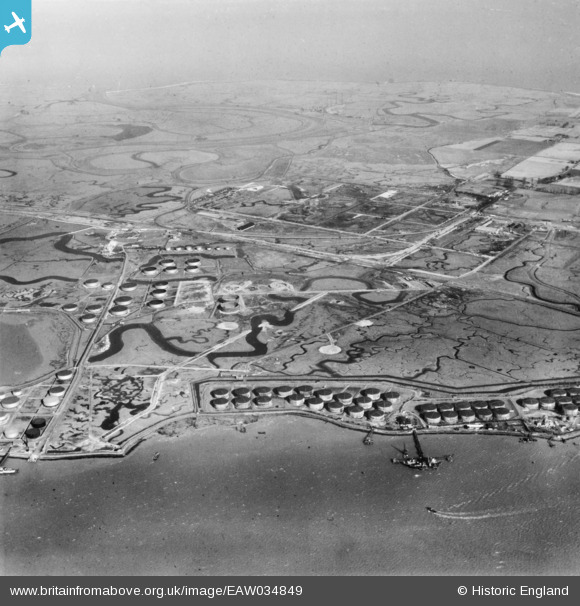
EAW034849 ENGLAND (1951). The Anglo-Iranian Oil Co oil refinery under construction, Isle of Grain, from the south, 1951. This image has been produced from a print.
© Copyright OpenStreetMap contributors and licensed by the OpenStreetMap Foundation. 2025. Cartography is licensed as CC BY-SA.
Details
| Title | [EAW034849] The Anglo-Iranian Oil Co oil refinery under construction, Isle of Grain, from the south, 1951. This image has been produced from a print. |
| Reference | EAW034849 |
| Date | 7-March-1951 |
| Link | |
| Place name | ISLE OF GRAIN |
| Parish | ISLE OF GRAIN |
| District | |
| Country | ENGLAND |
| Easting / Northing | 586631, 173914 |
| Longitude / Latitude | 0.6852521902749, 51.432950792939 |
| National Grid Reference | TQ866739 |
Pins

redmist |
Sunday 23rd of January 2022 04:16:32 PM | |

redmist |
Sunday 23rd of January 2022 04:14:35 PM | |

redmist |
Sunday 23rd of January 2022 04:11:02 PM | |

redmist |
Sunday 23rd of January 2022 04:09:20 PM | |

redmist |
Sunday 23rd of January 2022 02:43:36 PM |


![[EAW034849] The Anglo-Iranian Oil Co oil refinery under construction, Isle of Grain, from the south, 1951. This image has been produced from a print.](http://britainfromabove.org.uk/sites/all/libraries/aerofilms-images/public/100x100/EAW/034/EAW034849.jpg)
![[EAW039848] The Anglo-Iranian Oil Co oil refinery under construction, Isle of Grain, from the south, 1951. This image has been produced from a damaged negative.](http://britainfromabove.org.uk/sites/all/libraries/aerofilms-images/public/100x100/EAW/039/EAW039848.jpg)
![[EAW039849] The Anglo-Iranian Oil Co oil refinery under construction, Isle of Grain, from the south, 1951. This image has been produced from a damaged negative.](http://britainfromabove.org.uk/sites/all/libraries/aerofilms-images/public/100x100/EAW/039/EAW039849.jpg)