
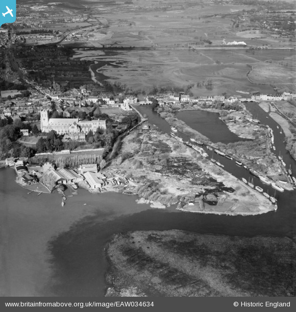
EAW034634 ENGLAND (1951). Christchurch Priory, Convent Meadows and environs, Christchurch, 1951
© Copyright OpenStreetMap contributors and licensed by the OpenStreetMap Foundation. 2026. Cartography is licensed as CC BY-SA.
Nearby Images (15)
EAW034634

EAW049063

EPW013616

EAW034633

EPW037439

EPW018171

EAW034630

EPR000281

EPW013615

EAW034632

EPR000280

EPW013614

EAW049062

EPW018172

EAW034629

Details
| Title | [EAW034634] Christchurch Priory, Convent Meadows and environs, Christchurch, 1951 |
| Reference | EAW034634 |
| Date | 7-February-1951 |
| Link | |
| Place name | CHRISTCHURCH |
| Parish | |
| District | |
| Country | ENGLAND |
| Easting / Northing | 416160, 92509 |
| Longitude / Latitude | -1.7709982891079, 50.731400191706 |
| National Grid Reference | SZ162925 |
Pins

Mike |
Saturday 28th of January 2017 01:28:00 PM | |

Peter Kazmierczak |
Tuesday 14th of October 2014 12:23:57 AM | |
|
Peter Kazmierczak |
Tuesday 14th of October 2014 12:22:53 AM | |
|
Peter Kazmierczak |
Tuesday 14th of October 2014 12:22:03 AM | |
|
Peter Kazmierczak |
Tuesday 14th of October 2014 12:20:36 AM | |
|
Peter Kazmierczak |
Tuesday 14th of October 2014 12:19:01 AM | |
|
cptpies |
Thursday 8th of May 2014 09:57:30 AM |
User Comment Contributions
WWII Type 22 Pillbox e11692 |
cptpies |
Thursday 8th of May 2014 09:59:20 AM |