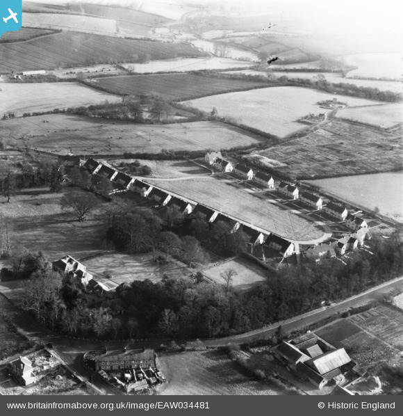
EAW034481 ENGLAND (1951). Meadow Close, Lavenham, 1951. This image has been produced from a print.
© Copyright OpenStreetMap contributors and licensed by the OpenStreetMap Foundation. 2026. Cartography is licensed as CC BY-SA.
Nearby Images (9)
Details
| Title | [EAW034481] Meadow Close, Lavenham, 1951. This image has been produced from a print. |
| Reference | EAW034481 |
| Date | 15-January-1951 |
| Link | |
| Place name | LAVENHAM |
| Parish | LAVENHAM |
| District | |
| Country | ENGLAND |
| Easting / Northing | 591380, 248751 |
| Longitude / Latitude | 0.79473160436325, 52.103518825173 |
| National Grid Reference | TL914488 |
Pins
Be the first to add a comment to this image!


![[EAW034481] Meadow Close, Lavenham, 1951. This image has been produced from a print.](http://britainfromabove.org.uk/sites/all/libraries/aerofilms-images/public/100x100/EAW/034/EAW034481.jpg)
![[EAW034476] Meadow Close and St Peter & St Paul's Church, Lavenham, 1951. This image has been produced from a print marked by Aerofilms Ltd for photo editing.](http://britainfromabove.org.uk/sites/all/libraries/aerofilms-images/public/100x100/EAW/034/EAW034476.jpg)
![[EAW034482] Meadow Close, Lavenham, 1951. This image has been produced from a print.](http://britainfromabove.org.uk/sites/all/libraries/aerofilms-images/public/100x100/EAW/034/EAW034482.jpg)
![[EAW034478] Meadow Close, Lavenham, 1951. This image has been produced from a print marked by Aerofilms Ltd for photo editing.](http://britainfromabove.org.uk/sites/all/libraries/aerofilms-images/public/100x100/EAW/034/EAW034478.jpg)
![[EAW034480] Meadow Close, Lavenham, 1951. This image has been produced from a print marked by Aerofilms Ltd for photo editing and affected by flare.](http://britainfromabove.org.uk/sites/all/libraries/aerofilms-images/public/100x100/EAW/034/EAW034480.jpg)
![[EAW034474] Meadow Close and St Peter & St Paul's Church, Lavenham, from the south-east, 1951. This image has been produced from a print marked by Aerofilms Ltd for photo editing.](http://britainfromabove.org.uk/sites/all/libraries/aerofilms-images/public/100x100/EAW/034/EAW034474.jpg)
![[EAW034475] Meadow Close and St Peter & St Paul's Church, Lavenham, from the south-east, 1951. This image has been produced from a print marked by Aerofilms Ltd for photo editing.](http://britainfromabove.org.uk/sites/all/libraries/aerofilms-images/public/100x100/EAW/034/EAW034475.jpg)
![[EAW034477] Meadow Close, Lavenham, from the east, 1951. This image has been produced from a print marked by Aerofilms Ltd for photo editing.](http://britainfromabove.org.uk/sites/all/libraries/aerofilms-images/public/100x100/EAW/034/EAW034477.jpg)
![[EAW034479] Meadow Close, Lavenham, from the east, 1951. This image has been produced from a print marked by Aerofilms Ltd for photo editing.](http://britainfromabove.org.uk/sites/all/libraries/aerofilms-images/public/100x100/EAW/034/EAW034479.jpg)