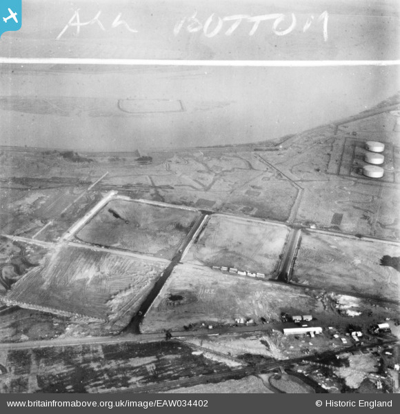
EAW034402 ENGLAND (1951). Part of the Coryton Oil Refinery under construction, Coryton, 1951. This image has been produced from a print marked by Aerofilms Ltd for photo editing.
© Copyright OpenStreetMap contributors and licensed by the OpenStreetMap Foundation. 2026. Cartography is licensed as CC BY-SA.
Nearby Images (37)
Details
| Title | [EAW034402] Part of the Coryton Oil Refinery under construction, Coryton, 1951. This image has been produced from a print marked by Aerofilms Ltd for photo editing. |
| Reference | EAW034402 |
| Date | 9-January-1951 |
| Link | |
| Place name | CORYTON |
| Parish | |
| District | |
| Country | ENGLAND |
| Easting / Northing | 574854, 182666 |
| Longitude / Latitude | 0.5203180039287, 51.515334771735 |
| National Grid Reference | TQ749827 |
Pins
Be the first to add a comment to this image!


![[EAW034402] Part of the Coryton Oil Refinery under construction, Coryton, 1951. This image has been produced from a print marked by Aerofilms Ltd for photo editing.](http://britainfromabove.org.uk/sites/all/libraries/aerofilms-images/public/100x100/EAW/034/EAW034402.jpg)
![[EAW047437] Part of the Coryton Oil Refinery, Coryton, 1952. This image was marked by Aerofilms Ltd for photo editing.](http://britainfromabove.org.uk/sites/all/libraries/aerofilms-images/public/100x100/EAW/047/EAW047437.jpg)
![[EAW048368] Flooding at the Coryton Oil Refinery, Coryton, 1953. This image was marked by Aerofilms Ltd for photo editing.](http://britainfromabove.org.uk/sites/all/libraries/aerofilms-images/public/100x100/EAW/048/EAW048368.jpg)
![[EAW048371] Flooding at the Coryton Oil Refinery, Coryton, 1953. This image was marked by Aerofilms Ltd for photo editing.](http://britainfromabove.org.uk/sites/all/libraries/aerofilms-images/public/100x100/EAW/048/EAW048371.jpg)
![[EAW034441] Part of the Coryton Oil Refinery under construction, Coryton, 1951. This image has been produced from a print marked by Aerofilms Ltd for photo editing.](http://britainfromabove.org.uk/sites/all/libraries/aerofilms-images/public/100x100/EAW/034/EAW034441.jpg)
![[EAW042270] The Coryton Oil Refinery, Coryton, 1952. This image was marked by Aerofilms Ltd for photo editing.](http://britainfromabove.org.uk/sites/all/libraries/aerofilms-images/public/100x100/EAW/042/EAW042270.jpg)
![[EAW048376] Flooding at the Coryton Oil Refinery, Coryton, from the north-west, 1953. This image was marked by Aerofilms Ltd for photo editing.](http://britainfromabove.org.uk/sites/all/libraries/aerofilms-images/public/100x100/EAW/048/EAW048376.jpg)
![[EAW041998] Coryton Oil Refinery, Corringham, 1952. This image was marked by Aerofilms Ltd for photo editing.](http://britainfromabove.org.uk/sites/all/libraries/aerofilms-images/public/100x100/EAW/041/EAW041998.jpg)
![[EAW047431] Coryton Oil Refinery, Coryton, 1952. This image was marked by Aerofilms Ltd for photo editing.](http://britainfromabove.org.uk/sites/all/libraries/aerofilms-images/public/100x100/EAW/047/EAW047431.jpg)
![[EAW048595] The Coryton Oil Refinery under construction, Coryton, 1953. This image was marked by Aerofilms Ltd for photo editing.](http://britainfromabove.org.uk/sites/all/libraries/aerofilms-images/public/100x100/EAW/048/EAW048595.jpg)
![[EAW039883] The Coryton Oil Refinery, Coryton, 1951. This image has been produced from a damaged negative.](http://britainfromabove.org.uk/sites/all/libraries/aerofilms-images/public/100x100/EAW/039/EAW039883.jpg)
![[EAW035785] Part of the Coryton Oil Refinery, Coryton, from the north, 1951. This image has been produced from a print marked by Aerofilms Ltd for photo editing.](http://britainfromabove.org.uk/sites/all/libraries/aerofilms-images/public/100x100/EAW/035/EAW035785.jpg)
![[EAW039882] The Coryton Oil Refinery, Coryton, 1951. This image has been produced from a damaged negative.](http://britainfromabove.org.uk/sites/all/libraries/aerofilms-images/public/100x100/EAW/039/EAW039882.jpg)
![[EAW042271] The Coryton Oil Refinery, Coryton, 1952. This image was marked by Aerofilms Ltd for photo editing.](http://britainfromabove.org.uk/sites/all/libraries/aerofilms-images/public/100x100/EAW/042/EAW042271.jpg)
![[EAW035782] Part of the Coryton Oil Refinery, Coryton, 1951. This image has been produced from a print marked by Aerofilms Ltd for photo editing.](http://britainfromabove.org.uk/sites/all/libraries/aerofilms-images/public/100x100/EAW/035/EAW035782.jpg)
![[EAW048374] Flooding at the Coryton Oil Refinery, Coryton, 1953. This image was marked by Aerofilms Ltd for photo editing.](http://britainfromabove.org.uk/sites/all/libraries/aerofilms-images/public/100x100/EAW/048/EAW048374.jpg)
![[EAW035777] Part of the Coryton Oil Refinery, Coryton, 1951. This image has been produced from a print marked by Aerofilms Ltd for photo editing.](http://britainfromabove.org.uk/sites/all/libraries/aerofilms-images/public/100x100/EAW/035/EAW035777.jpg)
![[EAW042275] The Coryton Oil Refinery, Coryton, 1952. This image was marked by Aerofilms Ltd for photo editing.](http://britainfromabove.org.uk/sites/all/libraries/aerofilms-images/public/100x100/EAW/042/EAW042275.jpg)
![[EAW034406] Part of the Coryton Oil Refinery under construction, Coryton, from the north-east, 1951. This image has been produced from a print marked by Aerofilms Ltd for photo editing.](http://britainfromabove.org.uk/sites/all/libraries/aerofilms-images/public/100x100/EAW/034/EAW034406.jpg)
![[EAW045727] The Coryton Oil Refinery, Coryton, 1952. This image was marked by Aerofilms Ltd for photo editing.](http://britainfromabove.org.uk/sites/all/libraries/aerofilms-images/public/100x100/EAW/045/EAW045727.jpg)
![[EAW039885] The Coryton Oil Refinery, Coryton, 1951](http://britainfromabove.org.uk/sites/all/libraries/aerofilms-images/public/100x100/EAW/039/EAW039885.jpg)
![[EAW045723] Upper Horse and the Coryton Oil Refinery, Coryton, 1952. This image was marked by Aerofilms Ltd for photo editing.](http://britainfromabove.org.uk/sites/all/libraries/aerofilms-images/public/100x100/EAW/045/EAW045723.jpg)
![[EAW048590] The Coryton Oil Refinery under construction, Coryton, 1953. This image was marked by Aerofilms Ltd for photo editing.](http://britainfromabove.org.uk/sites/all/libraries/aerofilms-images/public/100x100/EAW/048/EAW048590.jpg)
![[EAW039896] The Coryton Oil Refinery and the River Thames, Coryton, from the north-west, 1951. This image has been produced from a damaged negative.](http://britainfromabove.org.uk/sites/all/libraries/aerofilms-images/public/100x100/EAW/039/EAW039896.jpg)
![[EAW047424] Coryton Oil Refinery, Coryton, 1952. This image was marked by Aerofilms Ltd for photo editing.](http://britainfromabove.org.uk/sites/all/libraries/aerofilms-images/public/100x100/EAW/047/EAW047424.jpg)
![[EAW039897] The Coryton Oil Refinery and the River Thames, Coryton, from the north-west, 1951. This image has been produced from a damaged negative.](http://britainfromabove.org.uk/sites/all/libraries/aerofilms-images/public/100x100/EAW/039/EAW039897.jpg)
![[EAW043884] The Coryton Oil Refinery, Shell Haven, 1952. This image was marked by Aerofilms Ltd for photo editing.](http://britainfromabove.org.uk/sites/all/libraries/aerofilms-images/public/100x100/EAW/043/EAW043884.jpg)
![[EAW045722] Part of the Coryton Oil Refinery, Coryton, 1952. This image was marked by Aerofilms Ltd for photo editing.](http://britainfromabove.org.uk/sites/all/libraries/aerofilms-images/public/100x100/EAW/045/EAW045722.jpg)
![[EAW047425] Coryton Oil Refinery, Coryton, 1952. This image was marked by Aerofilms Ltd for photo editing.](http://britainfromabove.org.uk/sites/all/libraries/aerofilms-images/public/100x100/EAW/047/EAW047425.jpg)
![[EAW048375] Flooding at the Coryton Oil Refinery, Coryton, 1953. This image was marked by Aerofilms Ltd for photo editing.](http://britainfromabove.org.uk/sites/all/libraries/aerofilms-images/public/100x100/EAW/048/EAW048375.jpg)
![[EAW048093] Coryton Oil Refinery and environs, Coryton, 1952](http://britainfromabove.org.uk/sites/all/libraries/aerofilms-images/public/100x100/EAW/048/EAW048093.jpg)
![[EAW047436] Coryton Oil Refinery and Holehaven Creek, Coryton, 1952. This image was marked by Aerofilms Ltd for photo editing.](http://britainfromabove.org.uk/sites/all/libraries/aerofilms-images/public/100x100/EAW/047/EAW047436.jpg)
![[EAW042280] The Coryton Oil Refinery, Coryton, 1952. This image was marked by Aerofilms Ltd for photo editing.](http://britainfromabove.org.uk/sites/all/libraries/aerofilms-images/public/100x100/EAW/042/EAW042280.jpg)
![[EAW045726] The Coryton Oil Refinery, Coryton, 1952. This image was marked by Aerofilms Ltd for photo editing.](http://britainfromabove.org.uk/sites/all/libraries/aerofilms-images/public/100x100/EAW/045/EAW045726.jpg)
![[EAW045721] Part of the Coryton Oil Refinery, Coryton, 1952. This image was marked by Aerofilms Ltd for photo editing.](http://britainfromabove.org.uk/sites/all/libraries/aerofilms-images/public/100x100/EAW/045/EAW045721.jpg)
![[EAW048100] Coryton Oil Refinery, Coryton, 1952. This image was marked by Aerofilms Ltd for photo editing.](http://britainfromabove.org.uk/sites/all/libraries/aerofilms-images/public/100x100/EAW/048/EAW048100.jpg)
![[EAW047426] Coryton Oil Refinery, Coryton, 1952. This image was marked by Aerofilms Ltd for photo editing.](http://britainfromabove.org.uk/sites/all/libraries/aerofilms-images/public/100x100/EAW/047/EAW047426.jpg)