
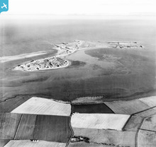
EAW034333 ENGLAND (1950). Holy Island, Holy Island, from the west, 1950. This image has been produced from a print.

© Copyright OpenStreetMap contributors and licensed by the OpenStreetMap Foundation. 2026. Cartography is licensed as CC BY-SA.
Nearby Images (2)
EAW034333

EAW034330

Details
| Title | [EAW034333] Holy Island, Holy Island, from the west, 1950. This image has been produced from a print. |
| Reference | EAW034333 |
| Date | 25-November-1950 |
| Link | |
| Place name | HOLY ISLAND |
| Parish | HOLY ISLAND |
| District | |
| Country | ENGLAND |
| Easting / Northing | 408593, 642699 |
| Longitude / Latitude | -1.8633422532886, 55.677714716717 |
| National Grid Reference | NU086427 |
Pins

Matt Aldred edob.mattaldred.com |
Thursday 31st of December 2020 03:29:27 PM | |
|
Matt Aldred edob.mattaldred.com |
Thursday 31st of December 2020 03:24:49 PM | |

jrussill |
Monday 17th of November 2014 11:16:35 AM |
User Comment Contributions
WW2 Anti Tank Blocks |
jrussill |
Monday 17th of November 2014 11:17:10 AM |