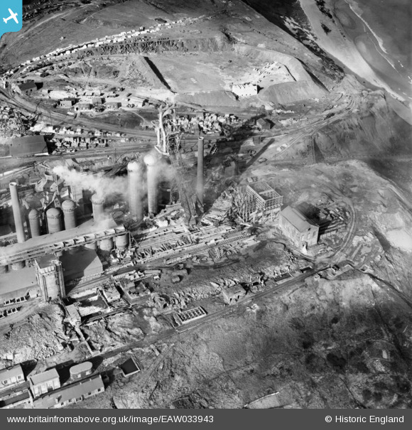
EAW033943 ENGLAND (1950). The Skinningrove Iron Co Ltd Works, Skinningrove, 1950
© Copyright OpenStreetMap contributors and licensed by the OpenStreetMap Foundation. 2026. Cartography is licensed as CC BY-SA.
Nearby Images (7)
Details
| Title | [EAW033943] The Skinningrove Iron Co Ltd Works, Skinningrove, 1950 |
| Reference | EAW033943 |
| Date | October-1950 |
| Link | |
| Place name | SKINNINGROVE |
| Parish | LOFTUS |
| District | |
| Country | ENGLAND |
| Easting / Northing | 471079, 520109 |
| Longitude / Latitude | -0.90041336669212, 54.571075133467 |
| National Grid Reference | NZ711201 |
Pins
Be the first to add a comment to this image!


![[EAW033943] The Skinningrove Iron Co Ltd Works, Skinningrove, 1950](http://britainfromabove.org.uk/sites/all/libraries/aerofilms-images/public/100x100/EAW/033/EAW033943.jpg)
![[EAW033938] Part of the Skinningrove Iron Co Ltd Works, Skinningrove, 1950. This image has been produced from a print.](http://britainfromabove.org.uk/sites/all/libraries/aerofilms-images/public/100x100/EAW/033/EAW033938.jpg)
![[EAW033942] The Skinningrove Iron Co Ltd Works, Skinningrove, 1950](http://britainfromabove.org.uk/sites/all/libraries/aerofilms-images/public/100x100/EAW/033/EAW033942.jpg)
![[EAW033940] The Skinningrove Iron Co Ltd Works, Skinningrove, 1950](http://britainfromabove.org.uk/sites/all/libraries/aerofilms-images/public/100x100/EAW/033/EAW033940.jpg)
![[EAW033944] The Skinningrove Iron Co Ltd Works, Skinningrove, 1950](http://britainfromabove.org.uk/sites/all/libraries/aerofilms-images/public/100x100/EAW/033/EAW033944.jpg)
![[EAW033939] The Skinningrove Iron Co Ltd Works, Skinningrove, 1950. This image was marked by Aerofilms Ltd for photo editing.](http://britainfromabove.org.uk/sites/all/libraries/aerofilms-images/public/100x100/EAW/033/EAW033939.jpg)
![[EAW033941] The Skinningrove Iron Co Ltd Works, Skinningrove, 1950](http://britainfromabove.org.uk/sites/all/libraries/aerofilms-images/public/100x100/EAW/033/EAW033941.jpg)