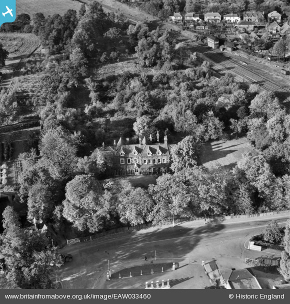
EAW033460 ENGLAND (1950). Manor House on Allum Lane, Borehamwood, 1950
© Copyright OpenStreetMap contributors and licensed by the OpenStreetMap Foundation. 2026. Cartography is licensed as CC BY-SA.
Nearby Images (17)
Details
| Title | [EAW033460] Manor House on Allum Lane, Borehamwood, 1950 |
| Reference | EAW033460 |
| Date | 12-October-1950 |
| Link | |
| Place name | BOREHAMWOOD |
| Parish | ELSTREE AND BOREHAMWOOD |
| District | |
| Country | ENGLAND |
| Easting / Northing | 518959, 196357 |
| Longitude / Latitude | -0.28022225635272, 51.652934738918 |
| National Grid Reference | TQ190964 |
Pins
Be the first to add a comment to this image!


![[EAW033460] Manor House on Allum Lane, Borehamwood, 1950](http://britainfromabove.org.uk/sites/all/libraries/aerofilms-images/public/100x100/EAW/033/EAW033460.jpg)
![[EAW033461] Manor House on Allum Lane, Borehamwood, 1950](http://britainfromabove.org.uk/sites/all/libraries/aerofilms-images/public/100x100/EAW/033/EAW033461.jpg)
![[EAW041450] Manor House, Boreham Holt and Allum Lane, Borehamwood, 1951](http://britainfromabove.org.uk/sites/all/libraries/aerofilms-images/public/100x100/EAW/041/EAW041450.jpg)
![[EAW041449] Manor House, Allum Lane and environs, Borehamwood, 1951](http://britainfromabove.org.uk/sites/all/libraries/aerofilms-images/public/100x100/EAW/041/EAW041449.jpg)
![[EAW041446] Manor House, Boreham Holt and environs, Borehamwood, 1951](http://britainfromabove.org.uk/sites/all/libraries/aerofilms-images/public/100x100/EAW/041/EAW041446.jpg)
![[EAW041447] Manor House, Allum Lane and environs, Borehamwood, 1951](http://britainfromabove.org.uk/sites/all/libraries/aerofilms-images/public/100x100/EAW/041/EAW041447.jpg)
![[EAW044079] Hollywood Court, the northern end of Elstree Tunnel and the surrounding area, Borehamwood, from the north-west, 1952](http://britainfromabove.org.uk/sites/all/libraries/aerofilms-images/public/100x100/EAW/044/EAW044079.jpg)
![[EAW041445] Manor House, Allum Lane and environs, Borehamwood, 1951](http://britainfromabove.org.uk/sites/all/libraries/aerofilms-images/public/100x100/EAW/041/EAW041445.jpg)
![[EAW041448] Manor House, Allum Lane and environs, Borehamwood, 1951](http://britainfromabove.org.uk/sites/all/libraries/aerofilms-images/public/100x100/EAW/041/EAW041448.jpg)
![[EAW041451] Manor House, Allum Lane and environs, Borehamwood, 1951](http://britainfromabove.org.uk/sites/all/libraries/aerofilms-images/public/100x100/EAW/041/EAW041451.jpg)
![[EAW041452] Theobald Street and environs, Borehamwood, 1951](http://britainfromabove.org.uk/sites/all/libraries/aerofilms-images/public/100x100/EAW/041/EAW041452.jpg)
![[EAW023319] Gate Film Studios on Station Road, Elstree and Borehamwood Railway Station and environs, Borehamwood, 1949](http://britainfromabove.org.uk/sites/all/libraries/aerofilms-images/public/100x100/EAW/023/EAW023319.jpg)
![[EAW041455] Shenley Road and environs, Borehamwood, 1951. This image has been produced from a print.](http://britainfromabove.org.uk/sites/all/libraries/aerofilms-images/public/100x100/EAW/041/EAW041455.jpg)
![[EAW041456] Theobald Street, Shenley Road and environs, Borehamwood, 1951. This image has been produced from a damaged negative.](http://britainfromabove.org.uk/sites/all/libraries/aerofilms-images/public/100x100/EAW/041/EAW041456.jpg)
![[EAW041453] Shenley Road and environs, Borehamwood, 1951. This image has been produced from a damaged negative.](http://britainfromabove.org.uk/sites/all/libraries/aerofilms-images/public/100x100/EAW/041/EAW041453.jpg)
![[EPW021917] Consolidated Film Studios, Borehamwood, 1928](http://britainfromabove.org.uk/sites/all/libraries/aerofilms-images/public/100x100/EPW/021/EPW021917.jpg)
![[EPW025491] The Whitehall Studio, Borehamwood, 1928.](http://britainfromabove.org.uk/sites/all/libraries/aerofilms-images/public/100x100/EPW/025/EPW025491.jpg)