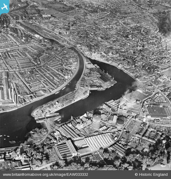
EAW033332 ENGLAND (1950). Ipswich Dock, New Cut and the town, Ipswich, 1950
© Copyright OpenStreetMap contributors and licensed by the OpenStreetMap Foundation. 2026. Cartography is licensed as CC BY-SA.
Nearby Images (21)
Details
| Title | [EAW033332] Ipswich Dock, New Cut and the town, Ipswich, 1950 |
| Reference | EAW033332 |
| Date | 5-October-1950 |
| Link | |
| Place name | IPSWICH |
| Parish | |
| District | |
| Country | ENGLAND |
| Easting / Northing | 616804, 243738 |
| Longitude / Latitude | 1.1622379468788, 52.049134596487 |
| National Grid Reference | TM168437 |
Pins
Be the first to add a comment to this image!


![[EAW033332] Ipswich Dock, New Cut and the town, Ipswich, 1950](http://britainfromabove.org.uk/sites/all/libraries/aerofilms-images/public/100x100/EAW/033/EAW033332.jpg)
![[EPW032837] The docks, Ipswich, 1930](http://britainfromabove.org.uk/sites/all/libraries/aerofilms-images/public/100x100/EPW/032/EPW032837.jpg)
![[EPW032856] Tovell's Wharf and environs, Ipswich, 1930](http://britainfromabove.org.uk/sites/all/libraries/aerofilms-images/public/100x100/EPW/032/EPW032856.jpg)
![[EPW032859] The docks and environs, Ipswich, 1930](http://britainfromabove.org.uk/sites/all/libraries/aerofilms-images/public/100x100/EPW/032/EPW032859.jpg)
![[EPW058769] The William Brown & Co (Ipswich) Ltd timber works, Three Cranes Wharf and environs, Ipswich, 1938](http://britainfromabove.org.uk/sites/all/libraries/aerofilms-images/public/100x100/EPW/058/EPW058769.jpg)
![[EPW032836] The docks, Ipswich, 1930](http://britainfromabove.org.uk/sites/all/libraries/aerofilms-images/public/100x100/EPW/032/EPW032836.jpg)
![[EPW058764] The William Brown & Co (Ipswich) Ltd timber works, Wet Dock and environs, Ipswich, 1938](http://britainfromabove.org.uk/sites/all/libraries/aerofilms-images/public/100x100/EPW/058/EPW058764.jpg)
![[EPW058768] The William Brown & Co (Ipswich) Ltd timber works, Wet Dock and environs, Ipswich, 1938](http://britainfromabove.org.uk/sites/all/libraries/aerofilms-images/public/100x100/EPW/058/EPW058768.jpg)
![[EPW032877] The docks and town, Ipswich, 1930](http://britainfromabove.org.uk/sites/all/libraries/aerofilms-images/public/100x100/EPW/032/EPW032877.jpg)
![[EPW058766] The William Brown & Co (Ipswich) Ltd timber works, Three Cranes Wharf and environs, Ipswich, 1938](http://britainfromabove.org.uk/sites/all/libraries/aerofilms-images/public/100x100/EPW/058/EPW058766.jpg)
![[EPW058765] The William Brown & Co (Ipswich) Ltd timber works, Wet Dock and environs, Ipswich, 1938](http://britainfromabove.org.uk/sites/all/libraries/aerofilms-images/public/100x100/EPW/058/EPW058765.jpg)
![[EPW058767] The William Brown & Co (Ipswich) Ltd timber works, Three Cranes Wharf and New Cut East, Ipswich, 1938](http://britainfromabove.org.uk/sites/all/libraries/aerofilms-images/public/100x100/EPW/058/EPW058767.jpg)
![[EPW005253] Ipswich and the Common Quay, Ipswich, from the south, 1921](http://britainfromabove.org.uk/sites/all/libraries/aerofilms-images/public/100x100/EPW/005/EPW005253.jpg)
![[EPW032853] The docks, Ipswich, 1930](http://britainfromabove.org.uk/sites/all/libraries/aerofilms-images/public/100x100/EPW/032/EPW032853.jpg)
![[EPW032845] The docks, Ipswich, 1930](http://britainfromabove.org.uk/sites/all/libraries/aerofilms-images/public/100x100/EPW/032/EPW032845.jpg)
![[EAW033334] Ipswich Dock, New Cut and the town, Ipswich, 1950](http://britainfromabove.org.uk/sites/all/libraries/aerofilms-images/public/100x100/EAW/033/EAW033334.jpg)
![[EAW033331] Ipswich Dock, New Cut and Stoke, Ipswich, 1950](http://britainfromabove.org.uk/sites/all/libraries/aerofilms-images/public/100x100/EAW/033/EAW033331.jpg)
![[EPW032858] The docks and environs, Ipswich, 1930](http://britainfromabove.org.uk/sites/all/libraries/aerofilms-images/public/100x100/EPW/032/EPW032858.jpg)
![[EPW032832] Tovell's Wharf and Common Quay, Ipswich, 1930](http://britainfromabove.org.uk/sites/all/libraries/aerofilms-images/public/100x100/EPW/032/EPW032832.jpg)
![[EPW032849] The Eagle Mills and docks, Ipswich, 1930](http://britainfromabove.org.uk/sites/all/libraries/aerofilms-images/public/100x100/EPW/032/EPW032849.jpg)
![[EPW059177] The town and River Orwell, Ipswich, from the west, 1938. This image has been produced from a copy-negative.](http://britainfromabove.org.uk/sites/all/libraries/aerofilms-images/public/100x100/EPW/059/EPW059177.jpg)