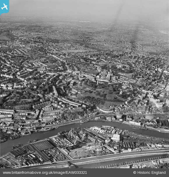
EAW033321 ENGLAND (1950). Brandon Hill and the city centre, Bristol, from the south, 1950
© Copyright OpenStreetMap contributors and licensed by the OpenStreetMap Foundation. 2026. Cartography is licensed as CC BY-SA.
Nearby Images (17)
Details
| Title | [EAW033321] Brandon Hill and the city centre, Bristol, from the south, 1950 |
| Reference | EAW033321 |
| Date | 5-October-1950 |
| Link | |
| Place name | BRISTOL |
| Parish | |
| District | |
| Country | ENGLAND |
| Easting / Northing | 357776, 172558 |
| Longitude / Latitude | -2.6076987358605, 51.449941769894 |
| National Grid Reference | ST578726 |
Pins
Be the first to add a comment to this image!


![[EAW033321] Brandon Hill and the city centre, Bristol, from the south, 1950](http://britainfromabove.org.uk/sites/all/libraries/aerofilms-images/public/100x100/EAW/033/EAW033321.jpg)
![[EAW250863] The steam ship SS Great Britain in Great Western Dry Dock, Bristol, 1973](http://britainfromabove.org.uk/sites/all/libraries/aerofilms-images/public/100x100/EAW/250/EAW250863.jpg)
![[EAW002260] Brandon Hill, Canon's Marsh and the city, Bristol, 1946](http://britainfromabove.org.uk/sites/all/libraries/aerofilms-images/public/100x100/EAW/002/EAW002260.jpg)
![[EPW001269] Bristol Cathedral and Brandon Hill with the Cabot Tower, 1920](http://britainfromabove.org.uk/sites/all/libraries/aerofilms-images/public/100x100/EPW/001/EPW001269.jpg)
![[EAW000702] Anchor Road and the Cathedral Garage looking towards Bellevue Crescent, 1946](http://britainfromabove.org.uk/sites/all/libraries/aerofilms-images/public/100x100/EAW/000/EAW000702.jpg)
![[EAW002261] Brandon Hill, Canon's Marsh and the city, Bristol, 1946](http://britainfromabove.org.uk/sites/all/libraries/aerofilms-images/public/100x100/EAW/002/EAW002261.jpg)
![[EAW033315] The Floating Harbour and Albion Dockyard, Bristol, 1950](http://britainfromabove.org.uk/sites/all/libraries/aerofilms-images/public/100x100/EAW/033/EAW033315.jpg)
![[EAW000701] Anchor Road and the Cathedral Garage looking towards Clifton Wood, Bristol, 1946](http://britainfromabove.org.uk/sites/all/libraries/aerofilms-images/public/100x100/EAW/000/EAW000701.jpg)
![[EAW000704] Brandon Hill and environs, Bristol, from the south-east, 1946](http://britainfromabove.org.uk/sites/all/libraries/aerofilms-images/public/100x100/EAW/000/EAW000704.jpg)
![[EAW000698] Brandon Hill, Bristol, 1946](http://britainfromabove.org.uk/sites/all/libraries/aerofilms-images/public/100x100/EAW/000/EAW000698.jpg)
![[EAW050554] The Floating Harbour, Bristol, from the north-west, 1953](http://britainfromabove.org.uk/sites/all/libraries/aerofilms-images/public/100x100/EAW/050/EAW050554.jpg)
![[EAW061875] Albion Dockyard, Bristol, 1955](http://britainfromabove.org.uk/sites/all/libraries/aerofilms-images/public/100x100/EAW/061/EAW061875.jpg)
![[EAW000705] Canon's Marsh Gas Works, Brandon Hill and environs, Bristol, from the south-east, 1946](http://britainfromabove.org.uk/sites/all/libraries/aerofilms-images/public/100x100/EAW/000/EAW000705.jpg)
![[EAW000699] Brandon Hill, St George's Road and environs, Bristol, 1946](http://britainfromabove.org.uk/sites/all/libraries/aerofilms-images/public/100x100/EAW/000/EAW000699.jpg)
![[EAW000703] The Cathedral Garage, Brandon Hill and environs, Bristol, 1946](http://britainfromabove.org.uk/sites/all/libraries/aerofilms-images/public/100x100/EAW/000/EAW000703.jpg)
![[EAW033316] HMS Flying Fox (Royal Naval Reserve) moored off Hotwell Road, Bristol, 1950](http://britainfromabove.org.uk/sites/all/libraries/aerofilms-images/public/100x100/EAW/033/EAW033316.jpg)
![[EAW002258] Brandon Hill, Canon's Marsh and the city, Bristol, 1946](http://britainfromabove.org.uk/sites/all/libraries/aerofilms-images/public/100x100/EAW/002/EAW002258.jpg)