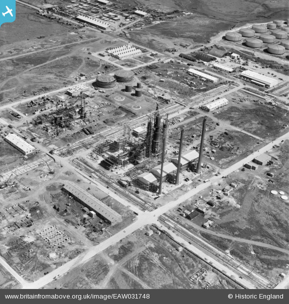
EAW031748 ENGLAND (1950). Construction work at the Shell Haven Oil Refinery, Corringham, 1950
© Copyright OpenStreetMap contributors and licensed by the OpenStreetMap Foundation. 2026. Cartography is licensed as CC BY-SA.
Nearby Images (48)
Details
| Title | [EAW031748] Construction work at the Shell Haven Oil Refinery, Corringham, 1950 |
| Reference | EAW031748 |
| Date | 4-August-1950 |
| Link | |
| Place name | CORRINGHAM |
| Parish | |
| District | |
| Country | ENGLAND |
| Easting / Northing | 571796, 181975 |
| Longitude / Latitude | 0.47594837285696, 51.51006507102 |
| National Grid Reference | TQ718820 |
Pins
Be the first to add a comment to this image!


![[EAW031748] Construction work at the Shell Haven Oil Refinery, Corringham, 1950](http://britainfromabove.org.uk/sites/all/libraries/aerofilms-images/public/100x100/EAW/031/EAW031748.jpg)
![[EAW021807] Part of the Shell Haven Oil Refinery under construction, Thames Haven, 1949](http://britainfromabove.org.uk/sites/all/libraries/aerofilms-images/public/100x100/EAW/021/EAW021807.jpg)
![[EAW024624] Part of the Shell Haven Oil Refinery under construction, Corringham, 1949](http://britainfromabove.org.uk/sites/all/libraries/aerofilms-images/public/100x100/EAW/024/EAW024624.jpg)
![[EAW031775] Construction works at the oil refinery, Corringham, 1950](http://britainfromabove.org.uk/sites/all/libraries/aerofilms-images/public/100x100/EAW/031/EAW031775.jpg)
![[EAW026766] Part of the Shell Haven Oil Refinery under construction, Corringham, 1949. This image was marked by Aerofilms Ltd for photo editing.](http://britainfromabove.org.uk/sites/all/libraries/aerofilms-images/public/100x100/EAW/026/EAW026766.jpg)
![[EAW034221] Part of the Shell Haven Oil Refinery, Corringham, 1950](http://britainfromabove.org.uk/sites/all/libraries/aerofilms-images/public/100x100/EAW/034/EAW034221.jpg)
![[EAW029138] Part of the Shell Haven Oil Refinery under construction, Corringham, 1950](http://britainfromabove.org.uk/sites/all/libraries/aerofilms-images/public/100x100/EAW/029/EAW029138.jpg)
![[EAW031745] Construction work at the Shell Haven Oil Refinery, Corringham, 1950. This image was marked by Aerofilms Ltd for photo editing.](http://britainfromabove.org.uk/sites/all/libraries/aerofilms-images/public/100x100/EAW/031/EAW031745.jpg)
![[EAW031747] Construction work at the Shell Haven Oil Refinery, Corringham, 1950. This image was marked by Aerofilms Ltd for photo editing.](http://britainfromabove.org.uk/sites/all/libraries/aerofilms-images/public/100x100/EAW/031/EAW031747.jpg)
![[EAW027721] Construction work at the Shell Haven Oil Refinery, Corringham, 1949](http://britainfromabove.org.uk/sites/all/libraries/aerofilms-images/public/100x100/EAW/027/EAW027721.jpg)
![[EAW031744] Part of the Shell Haven Oil Refinery, Corringham, 1950. This image was marked by Aerofilms Ltd for photo editing.](http://britainfromabove.org.uk/sites/all/libraries/aerofilms-images/public/100x100/EAW/031/EAW031744.jpg)
![[EAW034223] Part of the Shell Haven Oil Refinery, Corringham, 1950](http://britainfromabove.org.uk/sites/all/libraries/aerofilms-images/public/100x100/EAW/034/EAW034223.jpg)
![[EAW031746] Construction work at the Shell Haven Oil Refinery, Corringham, 1950](http://britainfromabove.org.uk/sites/all/libraries/aerofilms-images/public/100x100/EAW/031/EAW031746.jpg)
![[EAW027719] Construction work at the Shell Haven Oil Refinery, Corringham, 1949](http://britainfromabove.org.uk/sites/all/libraries/aerofilms-images/public/100x100/EAW/027/EAW027719.jpg)
![[EAW029139] Part of the Shell Haven Oil Refinery under construction, Corringham, 1950](http://britainfromabove.org.uk/sites/all/libraries/aerofilms-images/public/100x100/EAW/029/EAW029139.jpg)
![[EAW024621] Part of the Shell Haven Oil Refinery under construction, Corringham, 1949](http://britainfromabove.org.uk/sites/all/libraries/aerofilms-images/public/100x100/EAW/024/EAW024621.jpg)
![[EAW027723] Construction work at the Shell Haven Oil Refinery, Corringham, 1949](http://britainfromabove.org.uk/sites/all/libraries/aerofilms-images/public/100x100/EAW/027/EAW027723.jpg)
![[EAW024625] Part of the Shell Haven Oil Refinery under construction, Corringham, from the south, 1949](http://britainfromabove.org.uk/sites/all/libraries/aerofilms-images/public/100x100/EAW/024/EAW024625.jpg)
![[EAW021796] Part of the Shell Haven Oil Refinery under construction, Thames Haven, 1949](http://britainfromabove.org.uk/sites/all/libraries/aerofilms-images/public/100x100/EAW/021/EAW021796.jpg)
![[EAW026768] Part of the Shell Haven Oil Refinery under construction, Corringham, 1949. This image was marked by Aerofilms Ltd for photo editing.](http://britainfromabove.org.uk/sites/all/libraries/aerofilms-images/public/100x100/EAW/026/EAW026768.jpg)
![[EAW034220] Part of the Shell Haven Oil Refinery, Corringham, 1950](http://britainfromabove.org.uk/sites/all/libraries/aerofilms-images/public/100x100/EAW/034/EAW034220.jpg)
![[EAW027724] Construction work at the Shell Haven Oil Refinery, Corringham, 1949](http://britainfromabove.org.uk/sites/all/libraries/aerofilms-images/public/100x100/EAW/027/EAW027724.jpg)
![[EAW024620] Part of the Shell Haven Oil Refinery under construction, Corringham, 1949](http://britainfromabove.org.uk/sites/all/libraries/aerofilms-images/public/100x100/EAW/024/EAW024620.jpg)
![[EAW034222] Part of the Shell Haven Oil Refinery, Corringham, from the south, 1950](http://britainfromabove.org.uk/sites/all/libraries/aerofilms-images/public/100x100/EAW/034/EAW034222.jpg)
![[EAW021806] Part of the Shell Haven Oil Refinery under construction, Thames Haven, from the north-east, 1949](http://britainfromabove.org.uk/sites/all/libraries/aerofilms-images/public/100x100/EAW/021/EAW021806.jpg)
![[EAW024618] Part of the Shell Haven Oil Refinery under construction, Corringham, 1949](http://britainfromabove.org.uk/sites/all/libraries/aerofilms-images/public/100x100/EAW/024/EAW024618.jpg)
![[EAW024619] Part of the Shell Haven Oil Refinery under construction, Corringham, 1949](http://britainfromabove.org.uk/sites/all/libraries/aerofilms-images/public/100x100/EAW/024/EAW024619.jpg)
![[EAW027734] Construction work at the Shell Haven Oil Refinery, Corringham, 1949](http://britainfromabove.org.uk/sites/all/libraries/aerofilms-images/public/100x100/EAW/027/EAW027734.jpg)
![[EAW024617] Part of the Shell Haven Oil Refinery under construction, Corringham, 1949. This image was marked by Aerofilms Ltd for photo editing.](http://britainfromabove.org.uk/sites/all/libraries/aerofilms-images/public/100x100/EAW/024/EAW024617.jpg)
![[EAW026771] Part of the Shell Haven Oil Refinery under construction, Corringham, 1949](http://britainfromabove.org.uk/sites/all/libraries/aerofilms-images/public/100x100/EAW/026/EAW026771.jpg)
![[EAW026769] Part of the Shell Haven Oil Refinery under construction, Corringham, from the south-west, 1949](http://britainfromabove.org.uk/sites/all/libraries/aerofilms-images/public/100x100/EAW/026/EAW026769.jpg)
![[EAW031750] Part of the Shell Haven Oil Refinery, Corringham, 1950. This image was marked by Aerofilms Ltd for photo editing.](http://britainfromabove.org.uk/sites/all/libraries/aerofilms-images/public/100x100/EAW/031/EAW031750.jpg)
![[EAW034231] The Shell Haven Oil Refinery, Corringham, 1950. This image was marked by Aerofilms Ltd for photo editing.](http://britainfromabove.org.uk/sites/all/libraries/aerofilms-images/public/100x100/EAW/034/EAW034231.jpg)
![[EAW034235] The Shell Haven Oil Refinery, Corringham, 1950. This image was marked by Aerofilms Ltd for photo editing.](http://britainfromabove.org.uk/sites/all/libraries/aerofilms-images/public/100x100/EAW/034/EAW034235.jpg)
![[EAW031749] Part of the Shell Haven Oil Refinery, Corringham, 1950. This image was marked by Aerofilms Ltd for photo editing.](http://britainfromabove.org.uk/sites/all/libraries/aerofilms-images/public/100x100/EAW/031/EAW031749.jpg)
![[EAW034233] Part of the Shell Haven Oil Refinery, Corringham, 1950. This image was marked by Aerofilms Ltd for photo editing.](http://britainfromabove.org.uk/sites/all/libraries/aerofilms-images/public/100x100/EAW/034/EAW034233.jpg)
![[EAW026772] Part of the Shell Haven Oil Refinery under construction, Corringham, 1949](http://britainfromabove.org.uk/sites/all/libraries/aerofilms-images/public/100x100/EAW/026/EAW026772.jpg)
![[EAW034237] The Shell Haven Oil Refinery, Corringham, 1950. This image was marked by Aerofilms Ltd for photo editing.](http://britainfromabove.org.uk/sites/all/libraries/aerofilms-images/public/100x100/EAW/034/EAW034237.jpg)
![[EAW026770] Part of the Shell Haven Oil Refinery under construction, Corringham, 1949. This image was marked by Aerofilms Ltd for photo editing.](http://britainfromabove.org.uk/sites/all/libraries/aerofilms-images/public/100x100/EAW/026/EAW026770.jpg)
![[EAW027717] Construction work at the Shell Haven Oil Refinery, Corringham, 1949](http://britainfromabove.org.uk/sites/all/libraries/aerofilms-images/public/100x100/EAW/027/EAW027717.jpg)
![[EAW027718] Construction work at the Shell Haven Oil Refinery, Corringham, 1949](http://britainfromabove.org.uk/sites/all/libraries/aerofilms-images/public/100x100/EAW/027/EAW027718.jpg)
![[EAW034232] The Shell Haven Oil Refinery, Corringham, 1950. This image was marked by Aerofilms Ltd for photo editing.](http://britainfromabove.org.uk/sites/all/libraries/aerofilms-images/public/100x100/EAW/034/EAW034232.jpg)
![[EAW031751] Part of the Shell Haven Oil Refinery, Corringham, 1950. This image was marked by Aerofilms Ltd for photo editing.](http://britainfromabove.org.uk/sites/all/libraries/aerofilms-images/public/100x100/EAW/031/EAW031751.jpg)
![[EAW034236] The Shell Haven Oil Refinery, Corringham, 1950. This image was marked by Aerofilms Ltd for photo editing.](http://britainfromabove.org.uk/sites/all/libraries/aerofilms-images/public/100x100/EAW/034/EAW034236.jpg)
![[EAW034240] The Shell Haven Oil Refinery, Corringham, 1950. This image was marked by Aerofilms Ltd for photo editing.](http://britainfromabove.org.uk/sites/all/libraries/aerofilms-images/public/100x100/EAW/034/EAW034240.jpg)
![[EAW031741] Part of the Shell Haven Oil Refinery, Corringham, 1950. This image was marked by Aerofilms Ltd for photo editing.](http://britainfromabove.org.uk/sites/all/libraries/aerofilms-images/public/100x100/EAW/031/EAW031741.jpg)
![[EAW031742] Part of the Shell Haven Oil Refinery, Corringham, 1950](http://britainfromabove.org.uk/sites/all/libraries/aerofilms-images/public/100x100/EAW/031/EAW031742.jpg)
![[EAW024612] Part of the Shell Haven Oil Refinery under construction, Corringham, 1949. This image was marked by Aerofilms Ltd for photo editing.](http://britainfromabove.org.uk/sites/all/libraries/aerofilms-images/public/100x100/EAW/024/EAW024612.jpg)