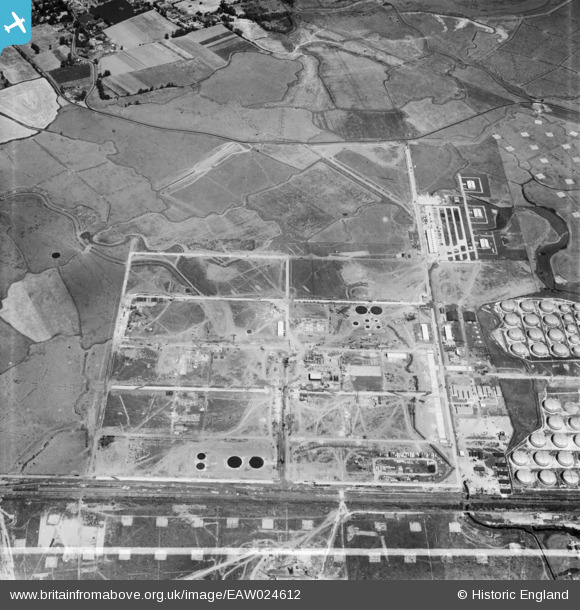
EAW024612 ENGLAND (1949). Part of the Shell Haven Oil Refinery under construction, Corringham, 1949. This image was marked by Aerofilms Ltd for photo editing.
© Copyright OpenStreetMap contributors and licensed by the OpenStreetMap Foundation. 2026. Cartography is licensed as CC BY-SA.
Nearby Images (31)
Details
| Title | [EAW024612] Part of the Shell Haven Oil Refinery under construction, Corringham, 1949. This image was marked by Aerofilms Ltd for photo editing. |
| Reference | EAW024612 |
| Date | 11-July-1949 |
| Link | |
| Place name | CORRINGHAM |
| Parish | |
| District | |
| Country | ENGLAND |
| Easting / Northing | 571709, 182215 |
| Longitude / Latitude | 0.47481267264423, 51.51224770086 |
| National Grid Reference | TQ717822 |
Pins
Be the first to add a comment to this image!


![[EAW024612] Part of the Shell Haven Oil Refinery under construction, Corringham, 1949. This image was marked by Aerofilms Ltd for photo editing.](http://britainfromabove.org.uk/sites/all/libraries/aerofilms-images/public/100x100/EAW/024/EAW024612.jpg)
![[EAW034236] The Shell Haven Oil Refinery, Corringham, 1950. This image was marked by Aerofilms Ltd for photo editing.](http://britainfromabove.org.uk/sites/all/libraries/aerofilms-images/public/100x100/EAW/034/EAW034236.jpg)
![[EAW026770] Part of the Shell Haven Oil Refinery under construction, Corringham, 1949. This image was marked by Aerofilms Ltd for photo editing.](http://britainfromabove.org.uk/sites/all/libraries/aerofilms-images/public/100x100/EAW/026/EAW026770.jpg)
![[EAW026772] Part of the Shell Haven Oil Refinery under construction, Corringham, 1949](http://britainfromabove.org.uk/sites/all/libraries/aerofilms-images/public/100x100/EAW/026/EAW026772.jpg)
![[EAW031751] Part of the Shell Haven Oil Refinery, Corringham, 1950. This image was marked by Aerofilms Ltd for photo editing.](http://britainfromabove.org.uk/sites/all/libraries/aerofilms-images/public/100x100/EAW/031/EAW031751.jpg)
![[EAW034232] The Shell Haven Oil Refinery, Corringham, 1950. This image was marked by Aerofilms Ltd for photo editing.](http://britainfromabove.org.uk/sites/all/libraries/aerofilms-images/public/100x100/EAW/034/EAW034232.jpg)
![[EAW026771] Part of the Shell Haven Oil Refinery under construction, Corringham, 1949](http://britainfromabove.org.uk/sites/all/libraries/aerofilms-images/public/100x100/EAW/026/EAW026771.jpg)
![[EAW034235] The Shell Haven Oil Refinery, Corringham, 1950. This image was marked by Aerofilms Ltd for photo editing.](http://britainfromabove.org.uk/sites/all/libraries/aerofilms-images/public/100x100/EAW/034/EAW034235.jpg)
![[EAW031750] Part of the Shell Haven Oil Refinery, Corringham, 1950. This image was marked by Aerofilms Ltd for photo editing.](http://britainfromabove.org.uk/sites/all/libraries/aerofilms-images/public/100x100/EAW/031/EAW031750.jpg)
![[EAW034231] The Shell Haven Oil Refinery, Corringham, 1950. This image was marked by Aerofilms Ltd for photo editing.](http://britainfromabove.org.uk/sites/all/libraries/aerofilms-images/public/100x100/EAW/034/EAW034231.jpg)
![[EAW034233] Part of the Shell Haven Oil Refinery, Corringham, 1950. This image was marked by Aerofilms Ltd for photo editing.](http://britainfromabove.org.uk/sites/all/libraries/aerofilms-images/public/100x100/EAW/034/EAW034233.jpg)
![[EAW031749] Part of the Shell Haven Oil Refinery, Corringham, 1950. This image was marked by Aerofilms Ltd for photo editing.](http://britainfromabove.org.uk/sites/all/libraries/aerofilms-images/public/100x100/EAW/031/EAW031749.jpg)
![[EAW034237] The Shell Haven Oil Refinery, Corringham, 1950. This image was marked by Aerofilms Ltd for photo editing.](http://britainfromabove.org.uk/sites/all/libraries/aerofilms-images/public/100x100/EAW/034/EAW034237.jpg)
![[EAW024613] Part of the Shell Haven Oil Refinery under construction, Corringham, 1949. This image was marked by Aerofilms Ltd for photo editing.](http://britainfromabove.org.uk/sites/all/libraries/aerofilms-images/public/100x100/EAW/024/EAW024613.jpg)
![[EAW024614] Part of the Shell Haven Oil Refinery under construction, Corringham, 1949. This image was marked by Aerofilms Ltd for photo editing.](http://britainfromabove.org.uk/sites/all/libraries/aerofilms-images/public/100x100/EAW/024/EAW024614.jpg)
![[EAW024616] The Shell Haven Oil Refinery, Corringham, 1949. This image was marked by Aerofilms Ltd for photo editing.](http://britainfromabove.org.uk/sites/all/libraries/aerofilms-images/public/100x100/EAW/024/EAW024616.jpg)
![[EAW024619] Part of the Shell Haven Oil Refinery under construction, Corringham, 1949](http://britainfromabove.org.uk/sites/all/libraries/aerofilms-images/public/100x100/EAW/024/EAW024619.jpg)
![[EAW024617] Part of the Shell Haven Oil Refinery under construction, Corringham, 1949. This image was marked by Aerofilms Ltd for photo editing.](http://britainfromabove.org.uk/sites/all/libraries/aerofilms-images/public/100x100/EAW/024/EAW024617.jpg)
![[EAW029140] Part of the Shell Haven Oil Refinery under construction, Corringham, 1950. This image was marked by Aerofilms Ltd for photo editing.](http://britainfromabove.org.uk/sites/all/libraries/aerofilms-images/public/100x100/EAW/029/EAW029140.jpg)
![[EAW021796] Part of the Shell Haven Oil Refinery under construction, Thames Haven, 1949](http://britainfromabove.org.uk/sites/all/libraries/aerofilms-images/public/100x100/EAW/021/EAW021796.jpg)
![[EAW034234] Part of the Shell Haven Oil Refinery, Corringham, 1950. This image was marked by Aerofilms Ltd for photo editing.](http://britainfromabove.org.uk/sites/all/libraries/aerofilms-images/public/100x100/EAW/034/EAW034234.jpg)
![[EAW024620] Part of the Shell Haven Oil Refinery under construction, Corringham, 1949](http://britainfromabove.org.uk/sites/all/libraries/aerofilms-images/public/100x100/EAW/024/EAW024620.jpg)
![[EAW027734] Construction work at the Shell Haven Oil Refinery, Corringham, 1949](http://britainfromabove.org.uk/sites/all/libraries/aerofilms-images/public/100x100/EAW/027/EAW027734.jpg)
![[EAW021806] Part of the Shell Haven Oil Refinery under construction, Thames Haven, from the north-east, 1949](http://britainfromabove.org.uk/sites/all/libraries/aerofilms-images/public/100x100/EAW/021/EAW021806.jpg)
![[EAW031748] Construction work at the Shell Haven Oil Refinery, Corringham, 1950](http://britainfromabove.org.uk/sites/all/libraries/aerofilms-images/public/100x100/EAW/031/EAW031748.jpg)
![[EAW021807] Part of the Shell Haven Oil Refinery under construction, Thames Haven, 1949](http://britainfromabove.org.uk/sites/all/libraries/aerofilms-images/public/100x100/EAW/021/EAW021807.jpg)
![[EAW024624] Part of the Shell Haven Oil Refinery under construction, Corringham, 1949](http://britainfromabove.org.uk/sites/all/libraries/aerofilms-images/public/100x100/EAW/024/EAW024624.jpg)
![[EAW029138] Part of the Shell Haven Oil Refinery under construction, Corringham, 1950](http://britainfromabove.org.uk/sites/all/libraries/aerofilms-images/public/100x100/EAW/029/EAW029138.jpg)
![[EAW027720] Construction work at the Shell Haven Oil Refinery, Corringham, 1949](http://britainfromabove.org.uk/sites/all/libraries/aerofilms-images/public/100x100/EAW/027/EAW027720.jpg)
![[EAW027719] Construction work at the Shell Haven Oil Refinery, Corringham, 1949](http://britainfromabove.org.uk/sites/all/libraries/aerofilms-images/public/100x100/EAW/027/EAW027719.jpg)
![[EAW024623] Part of the Shell Haven Oil Refinery under construction, Corringham, 1949. This image was marked by Aerofilms Ltd for photo editing.](http://britainfromabove.org.uk/sites/all/libraries/aerofilms-images/public/100x100/EAW/024/EAW024623.jpg)