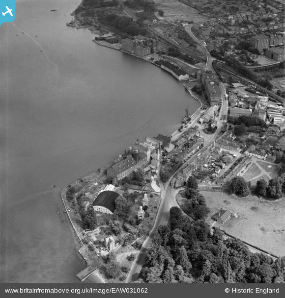
EAW031062 ENGLAND (1950). Brooks (Mistley) Ltd Works, Mistley Towers and the High Street, Mistley, 1950
© Copyright OpenStreetMap contributors and licensed by the OpenStreetMap Foundation. 2026. Cartography is licensed as CC BY-SA.
Nearby Images (10)
Details
| Title | [EAW031062] Brooks (Mistley) Ltd Works, Mistley Towers and the High Street, Mistley, 1950 |
| Reference | EAW031062 |
| Date | 19-July-1950 |
| Link | |
| Place name | MISTLEY |
| Parish | MISTLEY |
| District | |
| Country | ENGLAND |
| Easting / Northing | 611740, 231931 |
| Longitude / Latitude | 1.081199829814, 51.945080679644 |
| National Grid Reference | TM117319 |
Pins
Be the first to add a comment to this image!


![[EAW031062] Brooks (Mistley) Ltd Works, Mistley Towers and the High Street, Mistley, 1950](http://britainfromabove.org.uk/sites/all/libraries/aerofilms-images/public/100x100/EAW/031/EAW031062.jpg)
![[EAW031056] Brooks (Mistley) Ltd Works and Mistley Quay, Mistley, 1950. This image was marked by Aerofilms Ltd for photo editing.](http://britainfromabove.org.uk/sites/all/libraries/aerofilms-images/public/100x100/EAW/031/EAW031056.jpg)
![[EAW031055] Brooks (Mistley) Ltd Works, Mistley, 1950. This image was marked by Aerofilms Ltd for photo editing.](http://britainfromabove.org.uk/sites/all/libraries/aerofilms-images/public/100x100/EAW/031/EAW031055.jpg)
![[EAW031058] Brooks (Mistley) Ltd Works and Mistley Quay, Mistley, 1950. This image was marked by Aerofilms Ltd for photo editing.](http://britainfromabove.org.uk/sites/all/libraries/aerofilms-images/public/100x100/EAW/031/EAW031058.jpg)
![[EAW031060] Brooks (Mistley) Ltd Works, Mistley Quay and environs, Mistley, 1950. This image was marked by Aerofilms Ltd for photo editing.](http://britainfromabove.org.uk/sites/all/libraries/aerofilms-images/public/100x100/EAW/031/EAW031060.jpg)
![[EAW031061] Brooks (Mistley) Ltd Works, Mistley Quay and the High Street, Mistley, 1950. This image was marked by Aerofilms Ltd for photo editing.](http://britainfromabove.org.uk/sites/all/libraries/aerofilms-images/public/100x100/EAW/031/EAW031061.jpg)
![[EAW031063] Brooks (Mistley) Ltd Works, Mistley Green and environs, Mistley, 1950. This image was marked by Aerofilms Ltd for photo editing.](http://britainfromabove.org.uk/sites/all/libraries/aerofilms-images/public/100x100/EAW/031/EAW031063.jpg)
![[EAW031059] Brooks (Mistley) Ltd Works and Mistley Quay, Mistley, 1950. This image was marked by Aerofilms Ltd for photo editing.](http://britainfromabove.org.uk/sites/all/libraries/aerofilms-images/public/100x100/EAW/031/EAW031059.jpg)
![[EAW031057] The High Street and Mistley Quay, Mistley, 1950. This image was marked by Aerofilms Ltd for photo editing.](http://britainfromabove.org.uk/sites/all/libraries/aerofilms-images/public/100x100/EAW/031/EAW031057.jpg)
![[EAW031054] Brooks (Mistley) Ltd Works and Mistley Towers, Mistley, 1950. This image was marked by Aerofilms Ltd for photo editing.](http://britainfromabove.org.uk/sites/all/libraries/aerofilms-images/public/100x100/EAW/031/EAW031054.jpg)