
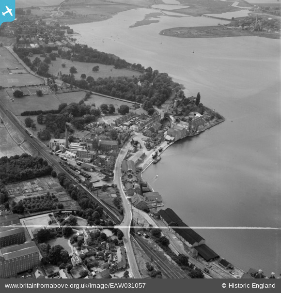
EAW031057 ENGLAND (1950). The High Street and Mistley Quay, Mistley, 1950. This image was marked by Aerofilms Ltd for photo editing.
© Copyright OpenStreetMap contributors and licensed by the OpenStreetMap Foundation. 2026. Cartography is licensed as CC BY-SA.
Nearby Images (10)
EAW031057

EAW031060
 Ltd Works, Mistley Quay and environs, Mistley, 1950. This image was marked by Aerofilms Ltd for photo editing.")
EAW031058
 Ltd Works and Mistley Quay, Mistley, 1950. This image was marked by Aerofilms Ltd for photo editing.")
EAW031063
 Ltd Works, Mistley Green and environs, Mistley, 1950. This image was marked by Aerofilms Ltd for photo editing.")
EAW031056
 Ltd Works and Mistley Quay, Mistley, 1950. This image was marked by Aerofilms Ltd for photo editing.")
EAW031062
 Ltd Works, Mistley Towers and the High Street, Mistley, 1950")
EAW031055
 Ltd Works, Mistley, 1950. This image was marked by Aerofilms Ltd for photo editing.")
EAW031061
 Ltd Works, Mistley Quay and the High Street, Mistley, 1950. This image was marked by Aerofilms Ltd for photo editing.")
EAW031059
 Ltd Works and Mistley Quay, Mistley, 1950. This image was marked by Aerofilms Ltd for photo editing.")
EAW031054
 Ltd Works and Mistley Towers, Mistley, 1950. This image was marked by Aerofilms Ltd for photo editing.")
Details
| Title | [EAW031057] The High Street and Mistley Quay, Mistley, 1950. This image was marked by Aerofilms Ltd for photo editing. |
| Reference | EAW031057 |
| Date | 19-July-1950 |
| Link | |
| Place name | MISTLEY |
| Parish | MISTLEY |
| District | |
| Country | ENGLAND |
| Easting / Northing | 611732, 231853 |
| Longitude / Latitude | 1.0810355651446, 51.94438337666 |
| National Grid Reference | TM117319 |
Pins

keithb |
Tuesday 7th of April 2015 03:41:58 PM |
