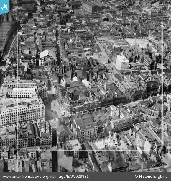
EAW029381 ENGLAND (1950). Old Square, Richard Lunt & Co Ltd Premises and environs, Birmingham, 1950. This image was marked by Aerofilms Ltd for photo editing.
© Copyright OpenStreetMap contributors and licensed by the OpenStreetMap Foundation. 2026. Cartography is licensed as CC BY-SA.
Nearby Images (30)
Details
| Title | [EAW029381] Old Square, Richard Lunt & Co Ltd Premises and environs, Birmingham, 1950. This image was marked by Aerofilms Ltd for photo editing. |
| Reference | EAW029381 |
| Date | 10-May-1950 |
| Link | |
| Place name | BIRMINGHAM |
| Parish | |
| District | |
| Country | ENGLAND |
| Easting / Northing | 407235, 287229 |
| Longitude / Latitude | -1.8934515405161, 52.482566321947 |
| National Grid Reference | SP072872 |
Pins
Be the first to add a comment to this image!


![[EAW029381] Old Square, Richard Lunt & Co Ltd Premises and environs, Birmingham, 1950. This image was marked by Aerofilms Ltd for photo editing.](http://britainfromabove.org.uk/sites/all/libraries/aerofilms-images/public/100x100/EAW/029/EAW029381.jpg)
![[EAW029377] Richard Lunt & Co Ltd Premises and environs, Birmingham, 1950. This image was marked by Aerofilms Ltd for photo editing.](http://britainfromabove.org.uk/sites/all/libraries/aerofilms-images/public/100x100/EAW/029/EAW029377.jpg)
![[EAW029383] Richard Lunt & Co Ltd Premises and environs, Birmingham, 1950. This image was marked by Aerofilms Ltd for photo editing.](http://britainfromabove.org.uk/sites/all/libraries/aerofilms-images/public/100x100/EAW/029/EAW029383.jpg)
![[EAW029419] Corporation Street, Steelhouse Lane and environs, Birmingham, 1950](http://britainfromabove.org.uk/sites/all/libraries/aerofilms-images/public/100x100/EAW/029/EAW029419.jpg)
![[EAW029376] Richard Lunt & Co Ltd Premises, Old Square and environs, Birmingham, 1950. This image was marked by Aerofilms Ltd for photo editing.](http://britainfromabove.org.uk/sites/all/libraries/aerofilms-images/public/100x100/EAW/029/EAW029376.jpg)
![[EAW029374] Richard Lunt & Co Ltd Premises and environs, Birmingham, 1950. This image was marked by Aerofilms Ltd for photo editing.](http://britainfromabove.org.uk/sites/all/libraries/aerofilms-images/public/100x100/EAW/029/EAW029374.jpg)
![[EAW029382] Richard Lunt & Co Ltd Premises and environs, Birmingham, 1950. This image was marked by Aerofilms Ltd for photo editing.](http://britainfromabove.org.uk/sites/all/libraries/aerofilms-images/public/100x100/EAW/029/EAW029382.jpg)
![[EAW029375] Richard Lunt & Co Ltd Premises and environs, Birmingham, 1950. This image was marked by Aerofilms Ltd for photo editing.](http://britainfromabove.org.uk/sites/all/libraries/aerofilms-images/public/100x100/EAW/029/EAW029375.jpg)
![[EAW029379] Richard Lunt & Co Ltd Premises and environs, Birmingham, 1950](http://britainfromabove.org.uk/sites/all/libraries/aerofilms-images/public/100x100/EAW/029/EAW029379.jpg)
![[EAW029378] Corporation Street, Richard Lunt & Co Ltd Premises and environs, Birmingham, 1950. This image has been produced from a damaged negative.](http://britainfromabove.org.uk/sites/all/libraries/aerofilms-images/public/100x100/EAW/029/EAW029378.jpg)
![[EAW029418] Corporation Street and Steelhouse Lane looking towards the Central Fire Station, Birmingham, 1950](http://britainfromabove.org.uk/sites/all/libraries/aerofilms-images/public/100x100/EAW/029/EAW029418.jpg)
![[EAW029380] Corporation Street, Richard Lunt & Co Ltd Premises and environs, Birmingham, 1950. This image was marked by Aerofilms Ltd for photo editing.](http://britainfromabove.org.uk/sites/all/libraries/aerofilms-images/public/100x100/EAW/029/EAW029380.jpg)
![[EPW041473] Steelhouse Lane, Corporation Street and environs, Birmingham, from the north-east, 1933](http://britainfromabove.org.uk/sites/all/libraries/aerofilms-images/public/100x100/EPW/041/EPW041473.jpg)
![[EAW036922] Lewis's Department Store on Corporation Street, Birmingham, 1951. This image has been produced from a print marked by Aerofilms Ltd for photo editing.](http://britainfromabove.org.uk/sites/all/libraries/aerofilms-images/public/100x100/EAW/036/EAW036922.jpg)
![[EPW037055] Old Square, Lewis's and environs, Birmingham, 1931](http://britainfromabove.org.uk/sites/all/libraries/aerofilms-images/public/100x100/EPW/037/EPW037055.jpg)
![[EAW029417] Lewis's Department Store (The Minories Building), Snows Hill Station and environs, Birmingham, from the east, 1950](http://britainfromabove.org.uk/sites/all/libraries/aerofilms-images/public/100x100/EAW/029/EAW029417.jpg)
![[EAW036920] Lewis's Department Store on Corporation Street, Birmingham, 1951. This image has been produced from a print marked by Aerofilms Ltd for photo editing.](http://britainfromabove.org.uk/sites/all/libraries/aerofilms-images/public/100x100/EAW/036/EAW036920.jpg)
![[EAW036919] Lewis's Department Store on Corporation Street, Birmingham, 1951. This image has been produced from a print marked by Aerofilms Ltd for photo editing.](http://britainfromabove.org.uk/sites/all/libraries/aerofilms-images/public/100x100/EAW/036/EAW036919.jpg)
![[EAW036923] Lewis's Department Store on Corporation Street, Birmingham, 1951. This image has been produced from a print marked by Aerofilms Ltd for photo editing.](http://britainfromabove.org.uk/sites/all/libraries/aerofilms-images/public/100x100/EAW/036/EAW036923.jpg)
![[EAW036924] Lewis's Department Store on Corporation Street, Birmingham, 1951. This image has been produced from a print marked by Aerofilms Ltd for photo editing.](http://britainfromabove.org.uk/sites/all/libraries/aerofilms-images/public/100x100/EAW/036/EAW036924.jpg)
![[EAW036925] Lewis's Department Store on Corporation Street, Birmingham, 1951. This image has been produced from a print marked by Aerofilms Ltd for photo editing.](http://britainfromabove.org.uk/sites/all/libraries/aerofilms-images/public/100x100/EAW/036/EAW036925.jpg)
![[EAW036918] Lewis's Department Store on Corporation Street, Birmingham, 1951. This image has been produced from a print marked by Aerofilms Ltd for photo editing.](http://britainfromabove.org.uk/sites/all/libraries/aerofilms-images/public/100x100/EAW/036/EAW036918.jpg)
![[EAW036921] Lewis's Department Store on Corporation Street, Birmingham, 1951. This image has been produced from a print marked by Aerofilms Ltd for photo editing.](http://britainfromabove.org.uk/sites/all/libraries/aerofilms-images/public/100x100/EAW/036/EAW036921.jpg)
![[EAW036926] Lewis's Department Store on Corporation Street, Birmingham, 1951. This image has been produced from a print marked by Aerofilms Ltd for photo editing.](http://britainfromabove.org.uk/sites/all/libraries/aerofilms-images/public/100x100/EAW/036/EAW036926.jpg)
![[EPW005856] Victoria Law Courts and the General Hospital, Birmingham, 1921. This image has been produced from a print.](http://britainfromabove.org.uk/sites/all/libraries/aerofilms-images/public/100x100/EPW/005/EPW005856.jpg)
![[EAW013570] The city centre including St Philip's Cathedral and Colmore Row, Birmingham, 1948](http://britainfromabove.org.uk/sites/all/libraries/aerofilms-images/public/100x100/EAW/013/EAW013570.jpg)
![[EAW013571] The city centre around Corporation Row, Birmingham, 1948](http://britainfromabove.org.uk/sites/all/libraries/aerofilms-images/public/100x100/EAW/013/EAW013571.jpg)
![[EAW026255] Snow Hill Station and the city centre, Birmingham, from the east, 1949](http://britainfromabove.org.uk/sites/all/libraries/aerofilms-images/public/100x100/EAW/026/EAW026255.jpg)
![[EAW013572] The city centre around Corporation Row, Birmingham, 1948](http://britainfromabove.org.uk/sites/all/libraries/aerofilms-images/public/100x100/EAW/013/EAW013572.jpg)
![[EPW005847] St Mary's Church and General Hospital off Whittall Street, Birmingham, 1921](http://britainfromabove.org.uk/sites/all/libraries/aerofilms-images/public/100x100/EPW/005/EPW005847.jpg)