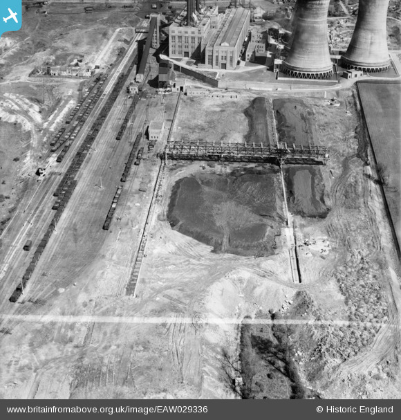
EAW029336 ENGLAND (1950). Construction of travelling crane at Walsall B Power Station, Walsall, 1950. This image was marked by Aerofilms Ltd for photo editing.
© Copyright OpenStreetMap contributors and licensed by the OpenStreetMap Foundation. 2026. Cartography is licensed as CC BY-SA.
Nearby Images (31)
Details
| Title | [EAW029336] Construction of travelling crane at Walsall B Power Station, Walsall, 1950. This image was marked by Aerofilms Ltd for photo editing. |
| Reference | EAW029336 |
| Date | 10-May-1950 |
| Link | |
| Place name | WALSALL |
| Parish | |
| District | |
| Country | ENGLAND |
| Easting / Northing | 399820, 299804 |
| Longitude / Latitude | -2.0026576464694, 52.595675054796 |
| National Grid Reference | SO998998 |
Pins

Class31 |
Monday 31st of March 2014 02:36:31 PM |


![[EAW029336] Construction of travelling crane at Walsall B Power Station, Walsall, 1950. This image was marked by Aerofilms Ltd for photo editing.](http://britainfromabove.org.uk/sites/all/libraries/aerofilms-images/public/100x100/EAW/029/EAW029336.jpg)
![[EAW025509] Engine Shed and adjacent coal store for Walsall B Power Station, Walsall, 1949. This image has been produced from a print.](http://britainfromabove.org.uk/sites/all/libraries/aerofilms-images/public/100x100/EAW/025/EAW025509.jpg)
![[EAW029342] Construction of travelling crane at Walsall B Power Station, Walsall, 1950](http://britainfromabove.org.uk/sites/all/libraries/aerofilms-images/public/100x100/EAW/029/EAW029342.jpg)
![[EAW029335] Construction of travelling crane at Walsall B Power Station and the site of Bentley Colliery, Walsall, from the south-east, 1950](http://britainfromabove.org.uk/sites/all/libraries/aerofilms-images/public/100x100/EAW/029/EAW029335.jpg)
![[EAW017210] Walsall B Power Station under construction and environs, Walsall, 1948](http://britainfromabove.org.uk/sites/all/libraries/aerofilms-images/public/100x100/EAW/017/EAW017210.jpg)
![[EAW017217] Walsall B Power Station under construction and environs, Walsall, 1948. This image has been produced from a damaged negative.](http://britainfromabove.org.uk/sites/all/libraries/aerofilms-images/public/100x100/EAW/017/EAW017217.jpg)
![[EAW020816] Birchills Power Station under construction, Walsall, 1949. This image has been produced from a print marked by Aerofilms Ltd for photo editing.](http://britainfromabove.org.uk/sites/all/libraries/aerofilms-images/public/100x100/EAW/020/EAW020816.jpg)
![[EAW025510] Coal store for Walsall B Power Station and the site of the Macadamising Works, Walsall, from the south, 1949. This image has been produced from a print.](http://britainfromabove.org.uk/sites/all/libraries/aerofilms-images/public/100x100/EAW/025/EAW025510.jpg)
![[EAW012899] Walsall B Power Station under construction at Reedswood, Birchills, 1948. This image was marked by Aerofilms Ltd for photo editing.](http://britainfromabove.org.uk/sites/all/libraries/aerofilms-images/public/100x100/EAW/012/EAW012899.jpg)
![[EAW012898] Walsall B Power Station under construction at Reedswood, Birchills, 1948. This image was marked by Aerofilms Ltd for photo editing.](http://britainfromabove.org.uk/sites/all/libraries/aerofilms-images/public/100x100/EAW/012/EAW012898.jpg)
![[EAW020817] Birchills Power Station under construction, Walsall, 1949. This image has been produced from a print marked by Aerofilms Ltd for photo editing.](http://britainfromabove.org.uk/sites/all/libraries/aerofilms-images/public/100x100/EAW/020/EAW020817.jpg)
![[EAW008398] Walsall B Power Station under construction, Walsall, 1947](http://britainfromabove.org.uk/sites/all/libraries/aerofilms-images/public/100x100/EAW/008/EAW008398.jpg)
![[EAW025503] Walsall B Power Station, Walsall, from the west, 1949. This image has been produced from a print.](http://britainfromabove.org.uk/sites/all/libraries/aerofilms-images/public/100x100/EAW/025/EAW025503.jpg)
![[EAW008392] Walsall B Power Station under construction, Walsall, 1947](http://britainfromabove.org.uk/sites/all/libraries/aerofilms-images/public/100x100/EAW/008/EAW008392.jpg)
![[EAW025516] Walsall B Power Station, Walsall, 1949. This image has been produced from a print marked by Aerofilms Ltd for photo editing.](http://britainfromabove.org.uk/sites/all/libraries/aerofilms-images/public/100x100/EAW/025/EAW025516.jpg)
![[EAW008400] Walsall B Power Station under construction, Walsall, 1947](http://britainfromabove.org.uk/sites/all/libraries/aerofilms-images/public/100x100/EAW/008/EAW008400.jpg)
![[EAW008402] Walsall B Power Station under construction, Walsall, 1947. This image was marked by Aerofilms Ltd for photo editing.](http://britainfromabove.org.uk/sites/all/libraries/aerofilms-images/public/100x100/EAW/008/EAW008402.jpg)
![[EAW008401] Walsall B Power Station under construction, Walsall, 1947](http://britainfromabove.org.uk/sites/all/libraries/aerofilms-images/public/100x100/EAW/008/EAW008401.jpg)
![[EAW008399] Walsall B Power Station under construction, Walsall, 1947. This image was marked by Aerofilms Ltd for photo editing.](http://britainfromabove.org.uk/sites/all/libraries/aerofilms-images/public/100x100/EAW/008/EAW008399.jpg)
![[EAW020826] Birchills Power Station under construction, Walsall, 1949](http://britainfromabove.org.uk/sites/all/libraries/aerofilms-images/public/100x100/EAW/020/EAW020826.jpg)
![[EAW025515] Walsall B Power Station under construction and the site of Bentley Hall Colliery, Walsall, 1949. This image has been produced from a print marked by Aerofilms Ltd for photo editing.](http://britainfromabove.org.uk/sites/all/libraries/aerofilms-images/public/100x100/EAW/025/EAW025515.jpg)
![[EAW008391] Walsall B Power Station under construction, Walsall, 1947](http://britainfromabove.org.uk/sites/all/libraries/aerofilms-images/public/100x100/EAW/008/EAW008391.jpg)
![[EAW025517] Walsall B Power Station, Walsall, from the west, 1949. This image has been produced from a print.](http://britainfromabove.org.uk/sites/all/libraries/aerofilms-images/public/100x100/EAW/025/EAW025517.jpg)
![[EAW013443] A cooling tower at Walsall B Power Station, Walsall, 1948](http://britainfromabove.org.uk/sites/all/libraries/aerofilms-images/public/100x100/EAW/013/EAW013443.jpg)
![[EAW020832] Birchills Power Station under construction, Walsall, 1949](http://britainfromabove.org.uk/sites/all/libraries/aerofilms-images/public/100x100/EAW/020/EAW020832.jpg)
![[EAW029328] Walsall B Power Station and environs, Walsall, from the south-west. 1950](http://britainfromabove.org.uk/sites/all/libraries/aerofilms-images/public/100x100/EAW/029/EAW029328.jpg)
![[EAW025507] Walsall B Power Station under construction, Walsall, 1949. This image has been produced from a print marked by Aerofilms Ltd for photo editing.](http://britainfromabove.org.uk/sites/all/libraries/aerofilms-images/public/100x100/EAW/025/EAW025507.jpg)
![[EAW025508] Walsall B Power Station under construction, Walsall, 1949. This image has been produced from a print.](http://britainfromabove.org.uk/sites/all/libraries/aerofilms-images/public/100x100/EAW/025/EAW025508.jpg)
![[EAW025512] The cooling towers at Walsall B Power Station, Walsall, 1949. This image has been produced from a print marked by Aerofilms Ltd for photo editing.](http://britainfromabove.org.uk/sites/all/libraries/aerofilms-images/public/100x100/EAW/025/EAW025512.jpg)
![[EAW029329] Walsall B Power Station and environs, Walsall, from the north-west. 1950](http://britainfromabove.org.uk/sites/all/libraries/aerofilms-images/public/100x100/EAW/029/EAW029329.jpg)
![[EAW013444] Cooling towers under construction at Walsall B Power Station, Walsall, 1948](http://britainfromabove.org.uk/sites/all/libraries/aerofilms-images/public/100x100/EAW/013/EAW013444.jpg)