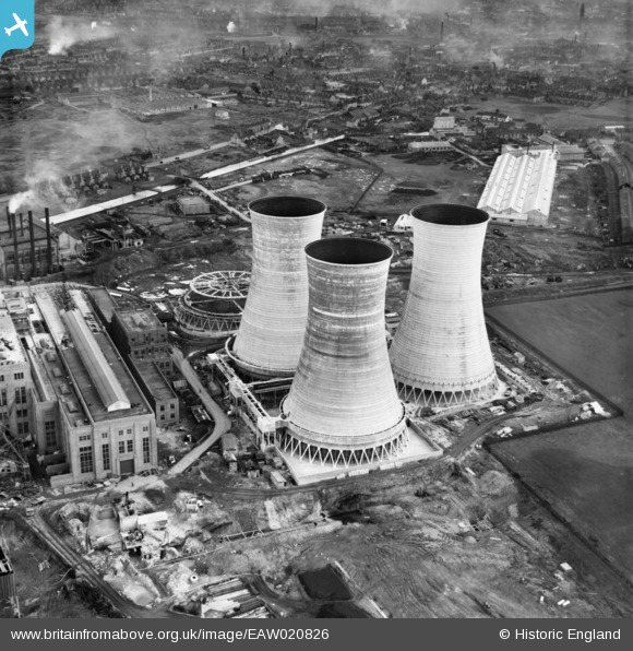
EAW020826 ENGLAND (1949). Birchills Power Station under construction, Walsall, 1949
© Copyright OpenStreetMap contributors and licensed by the OpenStreetMap Foundation. 2026. Cartography is licensed as CC BY-SA.
Nearby Images (48)
Details
| Title | [EAW020826] Birchills Power Station under construction, Walsall, 1949 |
| Reference | EAW020826 |
| Date | 20-January-1949 |
| Link | |
| Place name | WALSALL |
| Parish | |
| District | |
| Country | ENGLAND |
| Easting / Northing | 400041, 299763 |
| Longitude / Latitude | -1.9993946522733, 52.59530645896 |
| National Grid Reference | SP000998 |
Pins
Be the first to add a comment to this image!


![[EAW020826] Birchills Power Station under construction, Walsall, 1949](http://britainfromabove.org.uk/sites/all/libraries/aerofilms-images/public/100x100/EAW/020/EAW020826.jpg)
![[EAW008402] Walsall B Power Station under construction, Walsall, 1947. This image was marked by Aerofilms Ltd for photo editing.](http://britainfromabove.org.uk/sites/all/libraries/aerofilms-images/public/100x100/EAW/008/EAW008402.jpg)
![[EAW008400] Walsall B Power Station under construction, Walsall, 1947](http://britainfromabove.org.uk/sites/all/libraries/aerofilms-images/public/100x100/EAW/008/EAW008400.jpg)
![[EAW020832] Birchills Power Station under construction, Walsall, 1949](http://britainfromabove.org.uk/sites/all/libraries/aerofilms-images/public/100x100/EAW/020/EAW020832.jpg)
![[EAW025507] Walsall B Power Station under construction, Walsall, 1949. This image has been produced from a print marked by Aerofilms Ltd for photo editing.](http://britainfromabove.org.uk/sites/all/libraries/aerofilms-images/public/100x100/EAW/025/EAW025507.jpg)
![[EAW025516] Walsall B Power Station, Walsall, 1949. This image has been produced from a print marked by Aerofilms Ltd for photo editing.](http://britainfromabove.org.uk/sites/all/libraries/aerofilms-images/public/100x100/EAW/025/EAW025516.jpg)
![[EAW013443] A cooling tower at Walsall B Power Station, Walsall, 1948](http://britainfromabove.org.uk/sites/all/libraries/aerofilms-images/public/100x100/EAW/013/EAW013443.jpg)
![[EAW025503] Walsall B Power Station, Walsall, from the west, 1949. This image has been produced from a print.](http://britainfromabove.org.uk/sites/all/libraries/aerofilms-images/public/100x100/EAW/025/EAW025503.jpg)
![[EAW025512] The cooling towers at Walsall B Power Station, Walsall, 1949. This image has been produced from a print marked by Aerofilms Ltd for photo editing.](http://britainfromabove.org.uk/sites/all/libraries/aerofilms-images/public/100x100/EAW/025/EAW025512.jpg)
![[EAW008399] Walsall B Power Station under construction, Walsall, 1947. This image was marked by Aerofilms Ltd for photo editing.](http://britainfromabove.org.uk/sites/all/libraries/aerofilms-images/public/100x100/EAW/008/EAW008399.jpg)
![[EAW020824] Birchills Power Station under construction, Walsall, 1949](http://britainfromabove.org.uk/sites/all/libraries/aerofilms-images/public/100x100/EAW/020/EAW020824.jpg)
![[EAW008401] Walsall B Power Station under construction, Walsall, 1947](http://britainfromabove.org.uk/sites/all/libraries/aerofilms-images/public/100x100/EAW/008/EAW008401.jpg)
![[EAW020817] Birchills Power Station under construction, Walsall, 1949. This image has been produced from a print marked by Aerofilms Ltd for photo editing.](http://britainfromabove.org.uk/sites/all/libraries/aerofilms-images/public/100x100/EAW/020/EAW020817.jpg)
![[EAW008391] Walsall B Power Station under construction, Walsall, 1947](http://britainfromabove.org.uk/sites/all/libraries/aerofilms-images/public/100x100/EAW/008/EAW008391.jpg)
![[EAW013444] Cooling towers under construction at Walsall B Power Station, Walsall, 1948](http://britainfromabove.org.uk/sites/all/libraries/aerofilms-images/public/100x100/EAW/013/EAW013444.jpg)
![[EAW017219] Walsall B Power Station under construction (site of), Walsall, 1948. This image has been produced from a damaged negative.](http://britainfromabove.org.uk/sites/all/libraries/aerofilms-images/public/100x100/EAW/017/EAW017219.jpg)
![[EAW020818] Birchills Power Station under construction, Walsall, 1949. This image has been produced from a print.](http://britainfromabove.org.uk/sites/all/libraries/aerofilms-images/public/100x100/EAW/020/EAW020818.jpg)
![[EAW017212] Cooling towers at Walsall B Power Station, Walsall, 1948](http://britainfromabove.org.uk/sites/all/libraries/aerofilms-images/public/100x100/EAW/017/EAW017212.jpg)
![[EAW017218] Walsall B Power Station under construction and environs, Walsall, 1948. This image has been produced from a damaged negative.](http://britainfromabove.org.uk/sites/all/libraries/aerofilms-images/public/100x100/EAW/017/EAW017218.jpg)
![[EAW025515] Walsall B Power Station under construction and the site of Bentley Hall Colliery, Walsall, 1949. This image has been produced from a print marked by Aerofilms Ltd for photo editing.](http://britainfromabove.org.uk/sites/all/libraries/aerofilms-images/public/100x100/EAW/025/EAW025515.jpg)
![[EAW017211] Walsall B Power Station under construction, Walsall, 1948](http://britainfromabove.org.uk/sites/all/libraries/aerofilms-images/public/100x100/EAW/017/EAW017211.jpg)
![[EAW025508] Walsall B Power Station under construction, Walsall, 1949. This image has been produced from a print.](http://britainfromabove.org.uk/sites/all/libraries/aerofilms-images/public/100x100/EAW/025/EAW025508.jpg)
![[EAW025517] Walsall B Power Station, Walsall, from the west, 1949. This image has been produced from a print.](http://britainfromabove.org.uk/sites/all/libraries/aerofilms-images/public/100x100/EAW/025/EAW025517.jpg)
![[EAW012899] Walsall B Power Station under construction at Reedswood, Birchills, 1948. This image was marked by Aerofilms Ltd for photo editing.](http://britainfromabove.org.uk/sites/all/libraries/aerofilms-images/public/100x100/EAW/012/EAW012899.jpg)
![[EAW017215] Walsall B Power Station under construction, Walsall, 1948](http://britainfromabove.org.uk/sites/all/libraries/aerofilms-images/public/100x100/EAW/017/EAW017215.jpg)
![[EAW020815] Birchills Power Station under construction, Walsall, 1949. This image has been produced from a print.](http://britainfromabove.org.uk/sites/all/libraries/aerofilms-images/public/100x100/EAW/020/EAW020815.jpg)
![[EAW008393] Walsall B Power Station under construction, Walsall, 1947](http://britainfromabove.org.uk/sites/all/libraries/aerofilms-images/public/100x100/EAW/008/EAW008393.jpg)
![[EAW017220] Walsall B Power Station under construction, Walsall, 1948. This image has been produced from a print.](http://britainfromabove.org.uk/sites/all/libraries/aerofilms-images/public/100x100/EAW/017/EAW017220.jpg)
![[EAW020827] Birchills Power Station under construction, Walsall, 1949](http://britainfromabove.org.uk/sites/all/libraries/aerofilms-images/public/100x100/EAW/020/EAW020827.jpg)
![[EAW008392] Walsall B Power Station under construction, Walsall, 1947](http://britainfromabove.org.uk/sites/all/libraries/aerofilms-images/public/100x100/EAW/008/EAW008392.jpg)
![[EAW008398] Walsall B Power Station under construction, Walsall, 1947](http://britainfromabove.org.uk/sites/all/libraries/aerofilms-images/public/100x100/EAW/008/EAW008398.jpg)
![[EAW020816] Birchills Power Station under construction, Walsall, 1949. This image has been produced from a print marked by Aerofilms Ltd for photo editing.](http://britainfromabove.org.uk/sites/all/libraries/aerofilms-images/public/100x100/EAW/020/EAW020816.jpg)
![[EAW008397] Walsall B Power Station under construction, Walsall, 1947](http://britainfromabove.org.uk/sites/all/libraries/aerofilms-images/public/100x100/EAW/008/EAW008397.jpg)
![[EAW020821] Birchills Power Station under construction, Walsall, 1949. This image has been produced from a print marked by Aerofilms Ltd for photo editing.](http://britainfromabove.org.uk/sites/all/libraries/aerofilms-images/public/100x100/EAW/020/EAW020821.jpg)
![[EAW017217] Walsall B Power Station under construction and environs, Walsall, 1948. This image has been produced from a damaged negative.](http://britainfromabove.org.uk/sites/all/libraries/aerofilms-images/public/100x100/EAW/017/EAW017217.jpg)
![[EAW008396] Walsall B Power Station under construction, Walsall, 1947](http://britainfromabove.org.uk/sites/all/libraries/aerofilms-images/public/100x100/EAW/008/EAW008396.jpg)
![[EAW017213] Walsall B Power Station under construction, Walsall, 1948](http://britainfromabove.org.uk/sites/all/libraries/aerofilms-images/public/100x100/EAW/017/EAW017213.jpg)
![[EAW025523] Walsall B Power Station, Walsall, from the north, 1949. This image has been produced from a print.](http://britainfromabove.org.uk/sites/all/libraries/aerofilms-images/public/100x100/EAW/025/EAW025523.jpg)
![[EAW020823] Birchills Power Station under construction, Walsall, 1949. This image has been produced from a print.](http://britainfromabove.org.uk/sites/all/libraries/aerofilms-images/public/100x100/EAW/020/EAW020823.jpg)
![[EAW025504] Walsall B Power Station, Walsall, 1949. This image has been produced from a print.](http://britainfromabove.org.uk/sites/all/libraries/aerofilms-images/public/100x100/EAW/025/EAW025504.jpg)
![[EAW012898] Walsall B Power Station under construction at Reedswood, Birchills, 1948. This image was marked by Aerofilms Ltd for photo editing.](http://britainfromabove.org.uk/sites/all/libraries/aerofilms-images/public/100x100/EAW/012/EAW012898.jpg)
![[EAW017210] Walsall B Power Station under construction and environs, Walsall, 1948](http://britainfromabove.org.uk/sites/all/libraries/aerofilms-images/public/100x100/EAW/017/EAW017210.jpg)
![[EAW025510] Coal store for Walsall B Power Station and the site of the Macadamising Works, Walsall, from the south, 1949. This image has been produced from a print.](http://britainfromabove.org.uk/sites/all/libraries/aerofilms-images/public/100x100/EAW/025/EAW025510.jpg)
![[EAW017216] Walsall B Power Station under construction, Walsall, 1948. This image has been produced from a damaged negative.](http://britainfromabove.org.uk/sites/all/libraries/aerofilms-images/public/100x100/EAW/017/EAW017216.jpg)
![[EAW029342] Construction of travelling crane at Walsall B Power Station, Walsall, 1950](http://britainfromabove.org.uk/sites/all/libraries/aerofilms-images/public/100x100/EAW/029/EAW029342.jpg)
![[EAW029336] Construction of travelling crane at Walsall B Power Station, Walsall, 1950. This image was marked by Aerofilms Ltd for photo editing.](http://britainfromabove.org.uk/sites/all/libraries/aerofilms-images/public/100x100/EAW/029/EAW029336.jpg)
![[EAW025509] Engine Shed and adjacent coal store for Walsall B Power Station, Walsall, 1949. This image has been produced from a print.](http://britainfromabove.org.uk/sites/all/libraries/aerofilms-images/public/100x100/EAW/025/EAW025509.jpg)
![[EAW029335] Construction of travelling crane at Walsall B Power Station and the site of Bentley Colliery, Walsall, from the south-east, 1950](http://britainfromabove.org.uk/sites/all/libraries/aerofilms-images/public/100x100/EAW/029/EAW029335.jpg)