
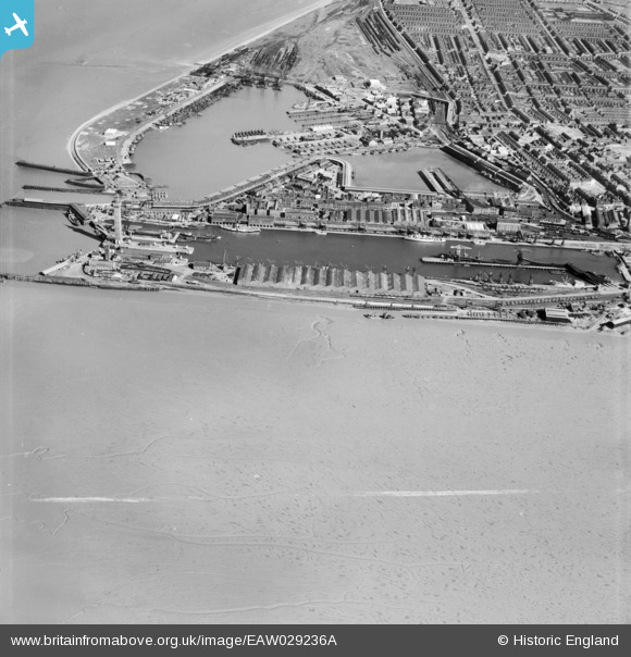
EAW029236A ENGLAND (1950). The docks, Grimsby, from the north-west, 1950. This image was marked by Aerofilms Ltd for photo editing.
© Copyright OpenStreetMap contributors and licensed by the OpenStreetMap Foundation. 2026. Cartography is licensed as CC BY-SA.
Nearby Images (2)
EAW029236A

EAW029231

Details
| Title | [EAW029236A] The docks, Grimsby, from the north-west, 1950. This image was marked by Aerofilms Ltd for photo editing. |
| Reference | EAW029236A |
| Date | 9-May-1950 |
| Link | |
| Place name | GRIMSBY |
| Parish | |
| District | |
| Country | ENGLAND |
| Easting / Northing | 527286, 411336 |
| Longitude / Latitude | -0.077047434438757, 53.582901860773 |
| National Grid Reference | TA273113 |
Pins

redmist |
Wednesday 31st of October 2018 09:33:51 PM | |

Class31 |
Monday 3rd of March 2014 07:12:36 PM | |
|
MB |
Friday 21st of February 2014 09:43:06 PM | |
|
MB |
Friday 21st of February 2014 09:42:22 PM | |
|
MB |
Friday 21st of February 2014 09:41:58 PM | |
|
MB |
Friday 21st of February 2014 09:40:36 PM | |
|
MB |
Friday 21st of February 2014 09:39:25 PM | |
|
MB |
Friday 21st of February 2014 09:39:05 PM | |
This is The Humber ferry PS Lincoln Castle of 1940. Served on the Hull - New Holland route until c1978 for British Railways and their successors. The last paddle steamer in regular service in the British Isles and coal fired until the end. Subsequently preserved in Hessle as a pub, she was regrettably broken up a few years ago back here in Grimsby. Her former consorts on the run, Wingfield Castle and Tattershall Castle of 1934 are still in existence,at Hartlepool and on the Thames respectively. |
John Wass |
Sunday 2nd of November 2014 08:37:27 PM |
|
MB |
Friday 21st of February 2014 09:38:35 PM | |
|
MB |
Friday 21st of February 2014 09:37:56 PM | |
|
MB |
Friday 21st of February 2014 09:37:25 PM | |
|
MB |
Friday 21st of February 2014 09:36:38 PM |