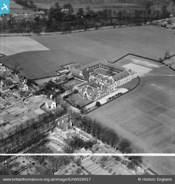
EAW028617 ENGLAND (1950). Queen Elizabeth's Grammar School (Boys), Mansfield Woodhouse, 1950. This image was marked by Aerofilms Ltd for photo editing.
© Copyright OpenStreetMap contributors and licensed by the OpenStreetMap Foundation. 2026. Cartography is licensed as CC BY-SA.
Nearby Images (8)
Details
| Title | [EAW028617] Queen Elizabeth's Grammar School (Boys), Mansfield Woodhouse, 1950. This image was marked by Aerofilms Ltd for photo editing. |
| Reference | EAW028617 |
| Date | 6-April-1950 |
| Link | |
| Place name | MANSFIELD WOODHOUSE |
| Parish | |
| District | |
| Country | ENGLAND |
| Easting / Northing | 453237, 362330 |
| Longitude / Latitude | -1.2037840104391, 53.155147816853 |
| National Grid Reference | SK532623 |
Pins
Be the first to add a comment to this image!


![[EAW028617] Queen Elizabeth's Grammar School (Boys), Mansfield Woodhouse, 1950. This image was marked by Aerofilms Ltd for photo editing.](http://britainfromabove.org.uk/sites/all/libraries/aerofilms-images/public/100x100/EAW/028/EAW028617.jpg)
![[EAW028618] Queen Elizabeth's Grammar School (Boys), Mansfield Woodhouse, 1950](http://britainfromabove.org.uk/sites/all/libraries/aerofilms-images/public/100x100/EAW/028/EAW028618.jpg)
![[EAW028616] Queen Elizabeth's Grammar School (Boys) and Sports Ground, Mansfield Woodhouse, 1950. This image was marked by Aerofilms Ltd for photo editing.](http://britainfromabove.org.uk/sites/all/libraries/aerofilms-images/public/100x100/EAW/028/EAW028616.jpg)
![[EAW028615] Queen Elizabeth's Grammar School (Boys) and Sports Ground, Mansfield Woodhouse, 1950. This image was marked by Aerofilms Ltd for photo editing.](http://britainfromabove.org.uk/sites/all/libraries/aerofilms-images/public/100x100/EAW/028/EAW028615.jpg)
![[EAW024142] Queen Elizabeth's Grammar School (Boys), Mansfield, from the north-east, 1949. This image has been produced from a damaged negative.](http://britainfromabove.org.uk/sites/all/libraries/aerofilms-images/public/100x100/EAW/024/EAW024142.jpg)
![[EAW024143] Queen Elizabeth's Grammar School (Boys) and environs, Mansfield, 1949. This image has been produced from a print marked by Aerofilms Ltd for photo editing.](http://britainfromabove.org.uk/sites/all/libraries/aerofilms-images/public/100x100/EAW/024/EAW024143.jpg)
![[EAW024144] Queen Elizabeth's Grammar School (Boys) and environs, Mansfield, 1949. This image has been produced from a print marked by Aerofilms Ltd for photo editing.](http://britainfromabove.org.uk/sites/all/libraries/aerofilms-images/public/100x100/EAW/024/EAW024144.jpg)
![[EAW024145] Queen Elizabeth's Grammar School (Boys), Mansfield, from the south-east, 1949. This image has been produced from a print marked by Aerofilms Ltd for photo editing.](http://britainfromabove.org.uk/sites/all/libraries/aerofilms-images/public/100x100/EAW/024/EAW024145.jpg)