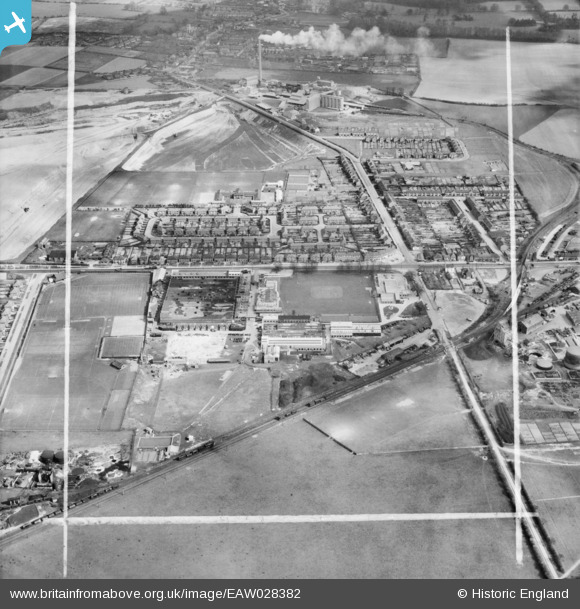
EAW028382 ENGLAND (1950). AC-Sphinx Spark Plug Co Works off High Street North and environs, Dunstable, 1950. This image was marked by Aerofilms Ltd for photo editing.
© Copyright OpenStreetMap contributors and licensed by the OpenStreetMap Foundation. 2026. Cartography is licensed as CC BY-SA.
Nearby Images (38)
Details
| Title | [EAW028382] AC-Sphinx Spark Plug Co Works off High Street North and environs, Dunstable, 1950. This image was marked by Aerofilms Ltd for photo editing. |
| Reference | EAW028382 |
| Date | 29-March-1950 |
| Link | |
| Place name | DUNSTABLE |
| Parish | DUNSTABLE |
| District | |
| Country | ENGLAND |
| Easting / Northing | 500951, 222797 |
| Longitude / Latitude | -0.53277375693689, 51.894131023357 |
| National Grid Reference | TL010228 |
Pins

Yargneb |
Thursday 30th of January 2020 01:45:25 PM |


![[EAW028382] AC-Sphinx Spark Plug Co Works off High Street North and environs, Dunstable, 1950. This image was marked by Aerofilms Ltd for photo editing.](http://britainfromabove.org.uk/sites/all/libraries/aerofilms-images/public/100x100/EAW/028/EAW028382.jpg)
![[EAW041800] The AC-Sphinx Sparking Plug Co Ltd Works, Dunstable, 1952](http://britainfromabove.org.uk/sites/all/libraries/aerofilms-images/public/100x100/EAW/041/EAW041800.jpg)
![[EAW041804] The AC-Sphinx Sparking Plug Co Ltd Works, Dunstable, 1952](http://britainfromabove.org.uk/sites/all/libraries/aerofilms-images/public/100x100/EAW/041/EAW041804.jpg)
![[EAW028377] AC-Sphinx Spark Plug Co Works off High Street North, Dunstable, 1950. This image was marked by Aerofilms Ltd for photo editing.](http://britainfromabove.org.uk/sites/all/libraries/aerofilms-images/public/100x100/EAW/028/EAW028377.jpg)
![[EAW041790] The AC-Sphinx Sparking Plug Co Ltd Works, Dunstable, 1952. This image has been produced from a print marked by Aerofilms Ltd for photo editing.](http://britainfromabove.org.uk/sites/all/libraries/aerofilms-images/public/100x100/EAW/041/EAW041790.jpg)
![[EAW041788] The AC-Sphinx Sparking Plug Co Ltd Works, Dunstable, 1952. This image has been produced from a print marked by Aerofilms Ltd for photo editing.](http://britainfromabove.org.uk/sites/all/libraries/aerofilms-images/public/100x100/EAW/041/EAW041788.jpg)
![[EAW028373] AC-Sphinx Spark Plug Co Works off High Street North, Dunstable, 1950. This image was marked by Aerofilms Ltd for photo editing.](http://britainfromabove.org.uk/sites/all/libraries/aerofilms-images/public/100x100/EAW/028/EAW028373.jpg)
![[EAW041789] The AC-Sphinx Sparking Plug Co Ltd Works, Dunstable, 1952. This image has been produced from a print marked by Aerofilms Ltd for photo editing.](http://britainfromabove.org.uk/sites/all/libraries/aerofilms-images/public/100x100/EAW/041/EAW041789.jpg)
![[EAW041805] The AC-Sphinx Sparking Plug Co Ltd Works, Dunstable, 1952](http://britainfromabove.org.uk/sites/all/libraries/aerofilms-images/public/100x100/EAW/041/EAW041805.jpg)
![[EAW041795] The AC-Sphinx Sparking Plug Co Ltd Works, Dunstable, 1952. This image was marked by Aerofilms Ltd for photo editing.](http://britainfromabove.org.uk/sites/all/libraries/aerofilms-images/public/100x100/EAW/041/EAW041795.jpg)
![[EAW041796] The AC-Sphinx Sparking Plug Co Ltd Works, Dunstable, 1952. This image was marked by Aerofilms Ltd for photo editing.](http://britainfromabove.org.uk/sites/all/libraries/aerofilms-images/public/100x100/EAW/041/EAW041796.jpg)
![[EAW041792] The AC-Sphinx Sparking Plug Co Ltd Works, Dunstable, 1952. This image was marked by Aerofilms Ltd for photo editing.](http://britainfromabove.org.uk/sites/all/libraries/aerofilms-images/public/100x100/EAW/041/EAW041792.jpg)
![[EAW051389] The AC-Delco Works, Dunstable, 1953. This image was marked by Aerofilms Ltd for photo editing.](http://britainfromabove.org.uk/sites/all/libraries/aerofilms-images/public/100x100/EAW/051/EAW051389.jpg)
![[EAW041794] The AC-Sphinx Sparking Plug Co Ltd Works, Dunstable, 1952. This image was marked by Aerofilms Ltd for photo editing.](http://britainfromabove.org.uk/sites/all/libraries/aerofilms-images/public/100x100/EAW/041/EAW041794.jpg)
![[EAW041793] The AC-Sphinx Sparking Plug Co Ltd Works, Dunstable, 1952. This image was marked by Aerofilms Ltd for photo editing.](http://britainfromabove.org.uk/sites/all/libraries/aerofilms-images/public/100x100/EAW/041/EAW041793.jpg)
![[EAW028378] AC-Sphinx Spark Plug Co Works off High Street North, Dunstable, 1950. This image was marked by Aerofilms Ltd for photo editing.](http://britainfromabove.org.uk/sites/all/libraries/aerofilms-images/public/100x100/EAW/028/EAW028378.jpg)
![[EAW041791] The AC-Sphinx Sparking Plug Co Ltd Works, Dunstable, 1952. This image has been produced from a print marked by Aerofilms Ltd for photo editing.](http://britainfromabove.org.uk/sites/all/libraries/aerofilms-images/public/100x100/EAW/041/EAW041791.jpg)
![[EAW041801] The AC-Sphinx Sparking Plug Co Ltd Works, Dunstable, 1952](http://britainfromabove.org.uk/sites/all/libraries/aerofilms-images/public/100x100/EAW/041/EAW041801.jpg)
![[EAW028379] AC-Sphinx Spark Plug Co Works off High Street North, Dunstable, 1950. This image was marked by Aerofilms Ltd for photo editing.](http://britainfromabove.org.uk/sites/all/libraries/aerofilms-images/public/100x100/EAW/028/EAW028379.jpg)
![[EAW051392] The AC-Delco Works, Dunstable, 1953. This image was marked by Aerofilms Ltd for photo editing.](http://britainfromabove.org.uk/sites/all/libraries/aerofilms-images/public/100x100/EAW/051/EAW051392.jpg)
![[EAW028384] AC-Sphinx Spark Plug Co Works off High Street North, Dunstable, 1950. This image was marked by Aerofilms Ltd for photo editing.](http://britainfromabove.org.uk/sites/all/libraries/aerofilms-images/public/100x100/EAW/028/EAW028384.jpg)
![[EAW051386] The AC-Delco Works, Dunstable, 1953. This image was marked by Aerofilms Ltd for photo editing.](http://britainfromabove.org.uk/sites/all/libraries/aerofilms-images/public/100x100/EAW/051/EAW051386.jpg)
![[EAW041803] The AC-Sphinx Sparking Plug Co Ltd Works, Dunstable, 1952](http://britainfromabove.org.uk/sites/all/libraries/aerofilms-images/public/100x100/EAW/041/EAW041803.jpg)
![[EAW041798] The AC-Sphinx Sparking Plug Co Ltd Works, Dunstable, 1952](http://britainfromabove.org.uk/sites/all/libraries/aerofilms-images/public/100x100/EAW/041/EAW041798.jpg)
![[EAW041806] The AC-Sphinx Sparking Plug Co Ltd Works, Dunstable, 1952](http://britainfromabove.org.uk/sites/all/libraries/aerofilms-images/public/100x100/EAW/041/EAW041806.jpg)
![[EAW051388] The AC-Delco Works, Dunstable, 1953. This image was marked by Aerofilms Ltd for photo editing.](http://britainfromabove.org.uk/sites/all/libraries/aerofilms-images/public/100x100/EAW/051/EAW051388.jpg)
![[EAW041797] The AC-Sphinx Sparking Plug Co Ltd Works, Dunstable, 1952. This image was marked by Aerofilms Ltd for photo editing.](http://britainfromabove.org.uk/sites/all/libraries/aerofilms-images/public/100x100/EAW/041/EAW041797.jpg)
![[EAW051390] The AC-Delco Works, Dunstable, 1953. This image was marked by Aerofilms Ltd for photo editing.](http://britainfromabove.org.uk/sites/all/libraries/aerofilms-images/public/100x100/EAW/051/EAW051390.jpg)
![[EAW028376] AC-Sphinx Spark Plug Co Works off High Street North, Dunstable, 1950. This image was marked by Aerofilms Ltd for photo editing.](http://britainfromabove.org.uk/sites/all/libraries/aerofilms-images/public/100x100/EAW/028/EAW028376.jpg)
![[EAW051387] The AC-Delco Works, Dunstable, 1953. This image was marked by Aerofilms Ltd for photo editing.](http://britainfromabove.org.uk/sites/all/libraries/aerofilms-images/public/100x100/EAW/051/EAW051387.jpg)
![[EAW051391] The AC-Delco Works, Dunstable, 1953. This image was marked by Aerofilms Ltd for photo editing.](http://britainfromabove.org.uk/sites/all/libraries/aerofilms-images/public/100x100/EAW/051/EAW051391.jpg)
![[EAW028374] AC-Sphinx Spark Plug Co Works off High Street North, Dunstable, 1950. This image was marked by Aerofilms Ltd for photo editing.](http://britainfromabove.org.uk/sites/all/libraries/aerofilms-images/public/100x100/EAW/028/EAW028374.jpg)
![[EAW028380] AC-Sphinx Spark Plug Co Works off High Street North, Dunstable, 1950. This image was marked by Aerofilms Ltd for photo editing.](http://britainfromabove.org.uk/sites/all/libraries/aerofilms-images/public/100x100/EAW/028/EAW028380.jpg)
![[EAW041802] The AC-Sphinx Sparking Plug Co Ltd Works, Dunstable, from the north, 1952](http://britainfromabove.org.uk/sites/all/libraries/aerofilms-images/public/100x100/EAW/041/EAW041802.jpg)
![[EAW041799] The AC-Sphinx Sparking Plug Co Ltd Works, Dunstable, from the north, 1952](http://britainfromabove.org.uk/sites/all/libraries/aerofilms-images/public/100x100/EAW/041/EAW041799.jpg)
![[EAW028381] AC-Sphinx Spark Plug Co Works off High Street North, Dunstable, 1950. This image was marked by Aerofilms Ltd for photo editing.](http://britainfromabove.org.uk/sites/all/libraries/aerofilms-images/public/100x100/EAW/028/EAW028381.jpg)
![[EAW028375] AC-Sphinx Spark Plug Co Works off High Street North, Dunstable, 1950. This image was marked by Aerofilms Ltd for photo editing.](http://britainfromabove.org.uk/sites/all/libraries/aerofilms-images/public/100x100/EAW/028/EAW028375.jpg)
![[EAW028383] AC-Sphinx Spark Plug Co Works off High Street North, Dunstable, 1950. This image was marked by Aerofilms Ltd for photo editing.](http://britainfromabove.org.uk/sites/all/libraries/aerofilms-images/public/100x100/EAW/028/EAW028383.jpg)