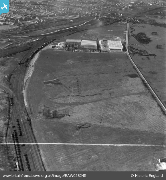
EAW028245 ENGLAND (1950). The British Rollmakers Corporation Works under construction alongside Weston Road, Crewe, 1950. This image has been produced from a print marked by Aerofilms Ltd for photo editing.
© Copyright OpenStreetMap contributors and licensed by the OpenStreetMap Foundation. 2026. Cartography is licensed as CC BY-SA.
Nearby Images (21)
Details
| Title | [EAW028245] The British Rollmakers Corporation Works under construction alongside Weston Road, Crewe, 1950. This image has been produced from a print marked by Aerofilms Ltd for photo editing. |
| Reference | EAW028245 |
| Date | 27-March-1950 |
| Link | |
| Place name | CREWE |
| Parish | |
| District | |
| Country | ENGLAND |
| Easting / Northing | 371706, 353998 |
| Longitude / Latitude | -2.4224479694846, 53.082154429457 |
| National Grid Reference | SJ717540 |
Pins
Be the first to add a comment to this image!


![[EAW028245] The British Rollmakers Corporation Works under construction alongside Weston Road, Crewe, 1950. This image has been produced from a print marked by Aerofilms Ltd for photo editing.](http://britainfromabove.org.uk/sites/all/libraries/aerofilms-images/public/100x100/EAW/028/EAW028245.jpg)
![[EAW035068] The Midland Rollmakers Ltd Works under construction, Crewe, 1951. This image was marked by Aerofilms Ltd for photo editing.](http://britainfromabove.org.uk/sites/all/libraries/aerofilms-images/public/100x100/EAW/035/EAW035068.jpg)
![[EAW028244] The British Rollmakers Corporation Works under construction alongside Weston Road, Crewe, 1950. This image has been produced from a print marked by Aerofilms Ltd for photo editing.](http://britainfromabove.org.uk/sites/all/libraries/aerofilms-images/public/100x100/EAW/028/EAW028244.jpg)
![[EAW035070] The Midland Rollmakers Ltd Works under construction, Crewe, 1951. This image was marked by Aerofilms Ltd for photo editing.](http://britainfromabove.org.uk/sites/all/libraries/aerofilms-images/public/100x100/EAW/035/EAW035070.jpg)
![[EAW017287] Construction of the Midland Rollmakers Ltd Works off Weston Road and the town, Crewe, 1948. This image has been produced from a print marked by Aerofilms Ltd for photo editing.](http://britainfromabove.org.uk/sites/all/libraries/aerofilms-images/public/100x100/EAW/017/EAW017287.jpg)
![[EAW017288] Construction of the Midland Rollmakers Ltd Works off Weston Road and the town, Crewe, 1948. This image has been produced from a print marked by Aerofilms Ltd for photo editing.](http://britainfromabove.org.uk/sites/all/libraries/aerofilms-images/public/100x100/EAW/017/EAW017288.jpg)
![[EAW021625] The British Rollmakers Corporation Works under construction and the surrounding area, Crewe, 1949. This image has been produced from a print marked by Aerofilms Ltd for photo editing.](http://britainfromabove.org.uk/sites/all/libraries/aerofilms-images/public/100x100/EAW/021/EAW021625.jpg)
![[EAW021627] The British Rollmakers Corporation Works under construction and the surrounding area, Crewe, 1949. This image has been produced from a print.](http://britainfromabove.org.uk/sites/all/libraries/aerofilms-images/public/100x100/EAW/021/EAW021627.jpg)
![[EAW035071] The Midland Rollmakers Ltd Works under construction, Crewe, 1951. This image was marked by Aerofilms Ltd for photo editing.](http://britainfromabove.org.uk/sites/all/libraries/aerofilms-images/public/100x100/EAW/035/EAW035071.jpg)
![[EAW021626] The British Rollmakers Corporation Works under construction and the surrounding area, Crewe, 1949. This image has been produced from a print marked by Aerofilms Ltd for photo editing.](http://britainfromabove.org.uk/sites/all/libraries/aerofilms-images/public/100x100/EAW/021/EAW021626.jpg)
![[EAW017286] Construction of the Midland Rollmakers Ltd Works off Weston Road, Crewe, 1948. This image has been produced from a print marked by Aerofilms Ltd for photo editing.](http://britainfromabove.org.uk/sites/all/libraries/aerofilms-images/public/100x100/EAW/017/EAW017286.jpg)
![[EAW028250] The British Rollmakers Corporation Works under construction alongside Weston Road, Crewe, 1950. This image has been produced from a print marked by Aerofilms Ltd for photo editing.](http://britainfromabove.org.uk/sites/all/libraries/aerofilms-images/public/100x100/EAW/028/EAW028250.jpg)
![[EAW017290] Construction of the Midland Rollmakers Ltd Works off Weston Road and environs, Crewe, 1948. This image has been produced from a print marked by Aerofilms Ltd for photo editing.](http://britainfromabove.org.uk/sites/all/libraries/aerofilms-images/public/100x100/EAW/017/EAW017290.jpg)
![[EAW028252] The British Rollmakers Corporation Works under construction alongside Weston Road, Crewe, 1950. This image has been produced from a print marked by Aerofilms Ltd for photo editing.](http://britainfromabove.org.uk/sites/all/libraries/aerofilms-images/public/100x100/EAW/028/EAW028252.jpg)
![[EAW028247] The British Rollmakers Corporation Works under construction alongside Weston Road, Crewe, 1950. This image has been produced from a print marked by Aerofilms Ltd for photo editing.](http://britainfromabove.org.uk/sites/all/libraries/aerofilms-images/public/100x100/EAW/028/EAW028247.jpg)
![[EAW017289] Construction of the Midland Rollmakers Ltd Works off Weston Road, Crewe, 1948. This image has been produced from a print marked by Aerofilms Ltd for photo editing.](http://britainfromabove.org.uk/sites/all/libraries/aerofilms-images/public/100x100/EAW/017/EAW017289.jpg)
![[EAW021631] The British Rollmakers Corporation Works under construction (site of) and the surrounding area, Crewe, 1949. This image has been produced from a damaged negative.](http://britainfromabove.org.uk/sites/all/libraries/aerofilms-images/public/100x100/EAW/021/EAW021631.jpg)
![[EAW017285] Construction of the Midland Rollmakers Ltd Works off Weston Road, Crewe, 1948. This image has been produced from a print marked by Aerofilms Ltd for photo editing.](http://britainfromabove.org.uk/sites/all/libraries/aerofilms-images/public/100x100/EAW/017/EAW017285.jpg)
![[EAW035065] The Midland Rollmakers Ltd Works under construction, Crewe, 1951](http://britainfromabove.org.uk/sites/all/libraries/aerofilms-images/public/100x100/EAW/035/EAW035065.jpg)
![[EAW021630] The British Rollmakers Corporation Works under construction and the surrounding area, Crewe, 1949. This image has been produced from a print.](http://britainfromabove.org.uk/sites/all/libraries/aerofilms-images/public/100x100/EAW/021/EAW021630.jpg)
![[EAW021632] The British Rollmakers Corporation Works under construction (site of), Crewe, 1949. This image has been produced from a damaged negative.](http://britainfromabove.org.uk/sites/all/libraries/aerofilms-images/public/100x100/EAW/021/EAW021632.jpg)