
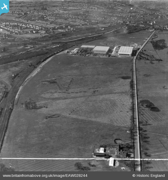
EAW028244 ENGLAND (1950). The British Rollmakers Corporation Works under construction alongside Weston Road, Crewe, 1950. This image has been produced from a print marked by Aerofilms Ltd for photo editing.
© Copyright OpenStreetMap contributors and licensed by the OpenStreetMap Foundation. 2026. Cartography is licensed as CC BY-SA.
Nearby Images (15)
EAW028244

EAW035068

EAW028245

EAW035070

EAW017287

EAW017288

EAW021625

EAW021627

EAW035071

EAW021626

EAW017286

EAW017290

EAW028250

EAW028252

EAW021631
 and the surrounding area, Crewe, 1949. This image has been produced from a damaged negative.")
Details
| Title | [EAW028244] The British Rollmakers Corporation Works under construction alongside Weston Road, Crewe, 1950. This image has been produced from a print marked by Aerofilms Ltd for photo editing. |
| Reference | EAW028244 |
| Date | 27-March-1950 |
| Link | |
| Place name | CREWE |
| Parish | |
| District | |
| Country | ENGLAND |
| Easting / Northing | 371747, 353990 |
| Longitude / Latitude | -2.4218351276847, 53.082084681849 |
| National Grid Reference | SJ717540 |
Pins

Matt Aldred edob.mattaldred.com |
Monday 11th of March 2024 03:26:21 PM | |

Neil |
Friday 20th of March 2015 11:39:08 PM |