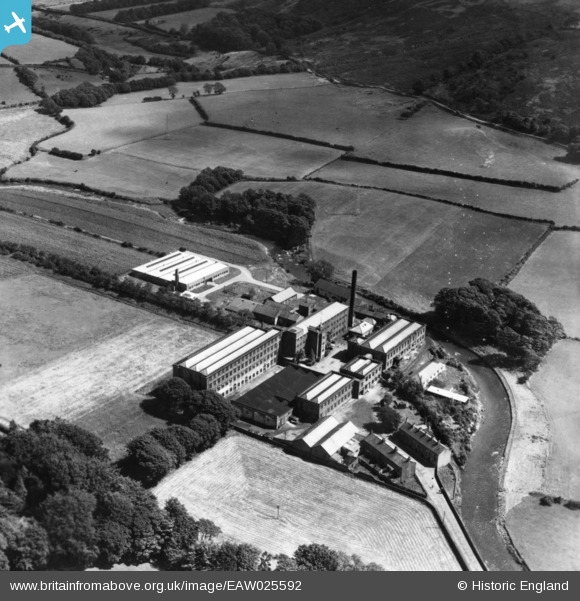
EAW025592 ENGLAND (1949). The Cleator Flax Mill, Cleator, 1949. This image has been produced from a print.
© Copyright OpenStreetMap contributors and licensed by the OpenStreetMap Foundation. 2024. Cartography is licensed as CC BY-SA.
Nearby Images (7)
Details
| Title | [EAW025592] The Cleator Flax Mill, Cleator, 1949. This image has been produced from a print. |
| Reference | EAW025592 |
| Date | 3-August-1949 |
| Link | |
| Place name | CLEATOR |
| Parish | CLEATOR MOOR |
| District | |
| Country | ENGLAND |
| Easting / Northing | 302094, 513722 |
| Longitude / Latitude | -3.5123356897603, 54.509208043357 |
| National Grid Reference | NY021137 |
Pins
Be the first to add a comment to this image!


![[EAW025592] The Cleator Flax Mill, Cleator, 1949. This image has been produced from a print.](http://britainfromabove.org.uk/sites/all/libraries/aerofilms-images/public/100x100/EAW/025/EAW025592.jpg)
![[EAW025594] The Cleator Flax Mill, Cleator, 1949. This image has been produced from a print marked by Aerofilms Ltd for photo editing.](http://britainfromabove.org.uk/sites/all/libraries/aerofilms-images/public/100x100/EAW/025/EAW025594.jpg)
![[EAW025590] The Cleator Flax Mill alongside The Flosh and environs, Cleator, from the east, 1949. This image has been produced from a print marked by Aerofilms Ltd for photo editing.](http://britainfromabove.org.uk/sites/all/libraries/aerofilms-images/public/100x100/EAW/025/EAW025590.jpg)
![[EAW025593] The Cleator Flax Mill, Cleator, 1949. This image has been produced from a print marked by Aerofilms Ltd for photo editing.](http://britainfromabove.org.uk/sites/all/libraries/aerofilms-images/public/100x100/EAW/025/EAW025593.jpg)
![[EAW025591] The Cleator Flax Mill, Cleator, 1949. This image has been produced from a print marked by Aerofilms Ltd for photo editing.](http://britainfromabove.org.uk/sites/all/libraries/aerofilms-images/public/100x100/EAW/025/EAW025591.jpg)
![[EAW025589] The Cleator Flax Mill and environs, Cleator, 1949. This image has been produced from a print marked by Aerofilms Ltd for photo editing.](http://britainfromabove.org.uk/sites/all/libraries/aerofilms-images/public/100x100/EAW/025/EAW025589.jpg)
![[EAW025588] The Cleator Flax Mill and environs, Cleator, from the south, 1949. This image has been produced from a print.](http://britainfromabove.org.uk/sites/all/libraries/aerofilms-images/public/100x100/EAW/025/EAW025588.jpg)