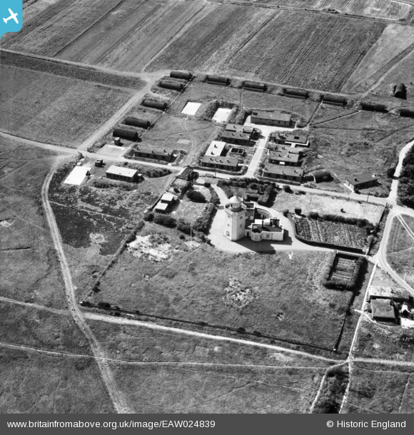
EAW024839 ENGLAND (1949). The South Foreland Lighthouse, South Foreland, 1949
© Copyright OpenStreetMap contributors and licensed by the OpenStreetMap Foundation. 2026. Cartography is licensed as CC BY-SA.
Nearby Images (7)
Details
| Title | [EAW024839] The South Foreland Lighthouse, South Foreland, 1949 |
| Reference | EAW024839 |
| Date | 12-July-1949 |
| Link | |
| Place name | SOUTH FORELAND |
| Parish | ST. MARGARET'S AT CLIFFE |
| District | |
| Country | ENGLAND |
| Easting / Northing | 635890, 143302 |
| Longitude / Latitude | 1.3725905057526, 51.13978187967 |
| National Grid Reference | TR359433 |
Pins
Be the first to add a comment to this image!


![[EAW024839] The South Foreland Lighthouse, South Foreland, 1949](http://britainfromabove.org.uk/sites/all/libraries/aerofilms-images/public/100x100/EAW/024/EAW024839.jpg)
![[EAW024838] The South Foreland Lighthouse, South Foreland, 1949](http://britainfromabove.org.uk/sites/all/libraries/aerofilms-images/public/100x100/EAW/024/EAW024838.jpg)
![[EPW017122] South Foreland and the South Foreland Lighthouse, St Margaret's at Cliffe, 1926](http://britainfromabove.org.uk/sites/all/libraries/aerofilms-images/public/100x100/EPW/017/EPW017122.jpg)
![[EAW024837] The South Foreland Lighthouse, South Foreland, 1949](http://britainfromabove.org.uk/sites/all/libraries/aerofilms-images/public/100x100/EAW/024/EAW024837.jpg)
![[EAW024836] The South Foreland Lighthouse, South Foreland, 1949](http://britainfromabove.org.uk/sites/all/libraries/aerofilms-images/public/100x100/EAW/024/EAW024836.jpg)
![[EAW020460] Chain Home Extra Low station K147, South Foreland Lighthouse and South Foreland Battery, St Margaret's at Cliffe, 1948](http://britainfromabove.org.uk/sites/all/libraries/aerofilms-images/public/100x100/EAW/020/EAW020460.jpg)
![[EAW020459] Wanstone Battery, Chain Home Extra Low station K147 and the South Foreland Lighthouse, St Margaret's at Cliffe, 1948](http://britainfromabove.org.uk/sites/all/libraries/aerofilms-images/public/100x100/EAW/020/EAW020459.jpg)