
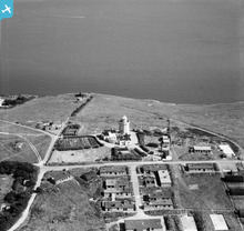
EAW024838 ENGLAND (1949). The South Foreland Lighthouse, South Foreland, 1949

© Copyright OpenStreetMap contributors and licensed by the OpenStreetMap Foundation. 2026. Cartography is licensed as CC BY-SA.
Nearby Images (8)
EAW024838

EAW024839

EAW024837

EPW017122

EAW024836

EAW020460

EAW020459

EAW020461

Details
| Title | [EAW024838] The South Foreland Lighthouse, South Foreland, 1949 |
| Reference | EAW024838 |
| Date | 12-July-1949 |
| Link | |
| Place name | SOUTH FORELAND |
| Parish | ST. MARGARET'S AT CLIFFE |
| District | |
| Country | ENGLAND |
| Easting / Northing | 635913, 143304 |
| Longitude / Latitude | 1.3729200431196, 51.139790359022 |
| National Grid Reference | TR359433 |
Pins

cptpies |
Thursday 9th of January 2014 09:24:28 AM |
User Comment Contributions
CHEL Station at South Foreland. |
cptpies |
Thursday 9th of January 2014 09:25:00 AM |