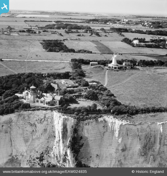
EAW024835 ENGLAND (1949). The Old Lighthouse and the windmill, South Foreland, 1949
    © Copyright OpenStreetMap contributors and licensed by the OpenStreetMap Foundation. 2025. Cartography is licensed as CC BY-SA.
  
Nearby Images (5)
Details
| Title | [EAW024835] The Old Lighthouse and the windmill, South Foreland, 1949 | 
| Reference | EAW024835 | 
| Date | 12-July-1949 | 
| Link | |
| Place name | SOUTH FORELAND | 
| Parish | ST. MARGARET'S AT CLIFFE | 
| District | |
| Country | ENGLAND | 
| Easting / Northing | 636277, 143431 | 
| Longitude / Latitude | 1.378197884505, 51.140780407133 | 
| National Grid Reference | TR363434 | 
Pins
|  WW2 Coastal Gun - South Foreland Battery |   jrussill | Wednesday 8th of January 2014 08:58:09 PM | 
User Comment Contributions
|   jrussill | Wednesday 8th of January 2014 09:00:24 PM | 
 
             
  ![[EAW024835] The Old Lighthouse and the windmill, South Foreland, 1949](http://britainfromabove.org.uk/sites/all/libraries/aerofilms-images/public/100x100/EAW/024/EAW024835.jpg) 
  
                                          ![[EAW024840] The windmill, South Foreland, 1949](http://britainfromabove.org.uk/sites/all/libraries/aerofilms-images/public/100x100/EAW/024/EAW024840.jpg) 
 ![[EPW035426] The Windmill and Old Lighthouse on top of chalk cliffs, South Foreland, from the east, 1931](http://britainfromabove.org.uk/sites/all/libraries/aerofilms-images/public/100x100/EPW/035/EPW035426.jpg) 
 ![[EAW020461] South Foreland Battery, South Foreland Old Lighthouse and the windmill, St Margaret's at Cliffe, 1948](http://britainfromabove.org.uk/sites/all/libraries/aerofilms-images/public/100x100/EAW/020/EAW020461.jpg) 
 ![[EAW020462] South Foreland Battery, the windmill and Whitecliff, St Margaret's at Cliffe, 1948](http://britainfromabove.org.uk/sites/all/libraries/aerofilms-images/public/100x100/EAW/020/EAW020462.jpg) 
 