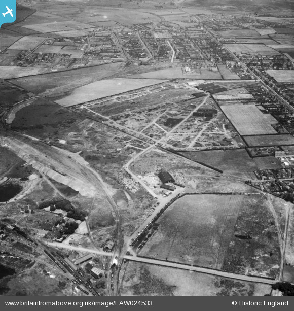
EAW024533 ENGLAND (1949). The site of the Cannock Chase Collieries, Chasetown, 1949
© Copyright OpenStreetMap contributors and licensed by the OpenStreetMap Foundation. 2026. Cartography is licensed as CC BY-SA.
Nearby Images (9)
Details
| Title | [EAW024533] The site of the Cannock Chase Collieries, Chasetown, 1949 |
| Reference | EAW024533 |
| Date | 8-July-1949 |
| Link | |
| Place name | CHASETOWN |
| Parish | BURNTWOOD |
| District | |
| Country | ENGLAND |
| Easting / Northing | 404114, 308585 |
| Longitude / Latitude | -1.939148594267, 52.674607429903 |
| National Grid Reference | SK041086 |
Pins
 Dolman St Store.jpg)
electricar.dv4 |
Monday 26th of September 2022 03:12:16 PM | |

areed |
Thursday 23rd of April 2020 09:17:16 PM | |

areed |
Thursday 23rd of April 2020 09:16:57 PM | |

areed |
Thursday 23rd of April 2020 09:16:43 PM | |

areed |
Thursday 23rd of April 2020 09:16:16 PM | |

areed |
Thursday 23rd of April 2020 09:12:34 PM | |

areed |
Thursday 23rd of April 2020 09:11:47 PM | |

Class31 |
Wednesday 15th of October 2014 04:48:48 PM |


![[EAW024533] The site of the Cannock Chase Collieries, Chasetown, 1949](http://britainfromabove.org.uk/sites/all/libraries/aerofilms-images/public/100x100/EAW/024/EAW024533.jpg)
![[EAW024532] The site of the Cannock Chase Collieries, Chasetown, 1949](http://britainfromabove.org.uk/sites/all/libraries/aerofilms-images/public/100x100/EAW/024/EAW024532.jpg)
![[EAW024541] Scrap processing on the site of Cannock Chase Collieries, Chasetown, from the south-west, 1949. This image has been produced from a print.](http://britainfromabove.org.uk/sites/all/libraries/aerofilms-images/public/100x100/EAW/024/EAW024541.jpg)
![[EAW024540] The site of the Cannock Chase Collieries, Chasetown, 1949. This image has been produced from a damaged negative.](http://britainfromabove.org.uk/sites/all/libraries/aerofilms-images/public/100x100/EAW/024/EAW024540.jpg)
![[EAW024536] The site of the Cannock Chase Collieries, Chasetown, 1949](http://britainfromabove.org.uk/sites/all/libraries/aerofilms-images/public/100x100/EAW/024/EAW024536.jpg)
![[EAW024537] The site of the Cannock Chase Collieries, Chasetown, 1949](http://britainfromabove.org.uk/sites/all/libraries/aerofilms-images/public/100x100/EAW/024/EAW024537.jpg)
![[EAW024535] The site of the Cannock Chase Collieries, Chasetown, 1949](http://britainfromabove.org.uk/sites/all/libraries/aerofilms-images/public/100x100/EAW/024/EAW024535.jpg)
![[EAW024542] Scrap processing on the site of Cannock Chase Collieries, Chasetown, 1949. This image has been produced from a print.](http://britainfromabove.org.uk/sites/all/libraries/aerofilms-images/public/100x100/EAW/024/EAW024542.jpg)
![[EPW015118] The village and environs, Chasetown, from the west, 1926](http://britainfromabove.org.uk/sites/all/libraries/aerofilms-images/public/100x100/EPW/015/EPW015118.jpg)