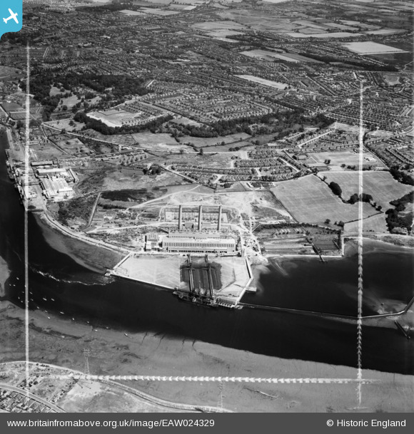
EAW024329 ENGLAND (1949). Cliff Quay Power Station, Ipswich, from the south-west, 1949. This image was marked by Aerofilms Ltd for photo editing.
© Copyright OpenStreetMap contributors and licensed by the OpenStreetMap Foundation. 2026. Cartography is licensed as CC BY-SA.
Nearby Images (48)
Details
| Title | [EAW024329] Cliff Quay Power Station, Ipswich, from the south-west, 1949. This image was marked by Aerofilms Ltd for photo editing. |
| Reference | EAW024329 |
| Date | 4-July-1949 |
| Link | |
| Place name | IPSWICH |
| Parish | |
| District | |
| Country | ENGLAND |
| Easting / Northing | 616850, 241822 |
| Longitude / Latitude | 1.1616926663689, 52.03191480564 |
| National Grid Reference | TM169418 |
Pins

Dazza |
Monday 26th of June 2023 11:51:09 PM |


![[EAW024329] Cliff Quay Power Station, Ipswich, from the south-west, 1949. This image was marked by Aerofilms Ltd for photo editing.](http://britainfromabove.org.uk/sites/all/libraries/aerofilms-images/public/100x100/EAW/024/EAW024329.jpg)
![[EAW012452] Cliff Quay Power Station under construction, Ipswich, from the south-west, 1947](http://britainfromabove.org.uk/sites/all/libraries/aerofilms-images/public/100x100/EAW/012/EAW012452.jpg)
![[EAW020667] Cliff Quay Power Station under construction, Ipswich, from the south-west, 1948](http://britainfromabove.org.uk/sites/all/libraries/aerofilms-images/public/100x100/EAW/020/EAW020667.jpg)
![[EAW020687] Cliff Quay Power Station under construction, Ipswich, 1948](http://britainfromabove.org.uk/sites/all/libraries/aerofilms-images/public/100x100/EAW/020/EAW020687.jpg)
![[EAW012453] The wharf at Cliff Quay Power Station and environs, Ipswich, from the south-east, 1947](http://britainfromabove.org.uk/sites/all/libraries/aerofilms-images/public/100x100/EAW/012/EAW012453.jpg)
![[EAW024322] Cliff Quay Power Station, Ipswich, 1949](http://britainfromabove.org.uk/sites/all/libraries/aerofilms-images/public/100x100/EAW/024/EAW024322.jpg)
![[EAW017564] Cliff Quay Power Station under construction, Ipswich, 1948. This image has been produced from a damaged negative.](http://britainfromabove.org.uk/sites/all/libraries/aerofilms-images/public/100x100/EAW/017/EAW017564.jpg)
![[EAW024321] Cliff Quay Power Station, Ipswich, 1949. This image was marked by Aerofilms Ltd for photo editing.](http://britainfromabove.org.uk/sites/all/libraries/aerofilms-images/public/100x100/EAW/024/EAW024321.jpg)
![[EAW024334] Cliff Quay Power Station, Ipswich, 1949. This image was marked by Aerofilms Ltd for photo editing.](http://britainfromabove.org.uk/sites/all/libraries/aerofilms-images/public/100x100/EAW/024/EAW024334.jpg)
![[EAW020689] Cliff Quay Power Station under construction, Ipswich, from the south-west, 1948](http://britainfromabove.org.uk/sites/all/libraries/aerofilms-images/public/100x100/EAW/020/EAW020689.jpg)
![[EAW020671] Cliff Quay Power Station under construction and the docks, Ipswich, from the south, 1948](http://britainfromabove.org.uk/sites/all/libraries/aerofilms-images/public/100x100/EAW/020/EAW020671.jpg)
![[EAW020676] Cliff Quay Power Station under construction, Ipswich, 1948](http://britainfromabove.org.uk/sites/all/libraries/aerofilms-images/public/100x100/EAW/020/EAW020676.jpg)
![[EAW033198] Cliff Quay Power Station and Coal Yards, Ipswich, 1950](http://britainfromabove.org.uk/sites/all/libraries/aerofilms-images/public/100x100/EAW/033/EAW033198.jpg)
![[EAW024333] Cliff Quay Power Station, Ipswich, 1949](http://britainfromabove.org.uk/sites/all/libraries/aerofilms-images/public/100x100/EAW/024/EAW024333.jpg)
![[EAW027812] The Cliff Quay Power Station and Coal Yards, Ipswich, 1949. This image was marked by Aerofilms Ltd for photo editing.](http://britainfromabove.org.uk/sites/all/libraries/aerofilms-images/public/100x100/EAW/027/EAW027812.jpg)
![[EAW008078] Cliff Quay Power Station under construction, Ipswich, 1947. This image was marked by Aerofilms Ltd for photo editing.](http://britainfromabove.org.uk/sites/all/libraries/aerofilms-images/public/100x100/EAW/008/EAW008078.jpg)
![[EAW027819] The Cliff Quay Power Station and Coal Yards, Ipswich, 1949. This image was marked by Aerofilms Ltd for photo editing.](http://britainfromabove.org.uk/sites/all/libraries/aerofilms-images/public/100x100/EAW/027/EAW027819.jpg)
![[EAW027823] The Cliff Quay Power Station and Coal Yards, Ipswich, 1949. This image was marked by Aerofilms Ltd for photo editing.](http://britainfromabove.org.uk/sites/all/libraries/aerofilms-images/public/100x100/EAW/027/EAW027823.jpg)
![[EAW027815] The Cliff Quay Power Station and Coal Yards, Ipswich, 1949. This image was marked by Aerofilms Ltd for photo editing.](http://britainfromabove.org.uk/sites/all/libraries/aerofilms-images/public/100x100/EAW/027/EAW027815.jpg)
![[EAW027822] The Cliff Quay Power Station and Coal Yards, Ipswich, 1949](http://britainfromabove.org.uk/sites/all/libraries/aerofilms-images/public/100x100/EAW/027/EAW027822.jpg)
![[EAW017568] Cliff Quay Power Station under construction, Ipswich, 1948](http://britainfromabove.org.uk/sites/all/libraries/aerofilms-images/public/100x100/EAW/017/EAW017568.jpg)
![[EAW008083] Cliff Quay Power Station under construction, Ipswich, 1947](http://britainfromabove.org.uk/sites/all/libraries/aerofilms-images/public/100x100/EAW/008/EAW008083.jpg)
![[EAW020681] Cliff Quay Power Station under construction and the Ipswich Corporation Sewage Works, Ipswich, 1948](http://britainfromabove.org.uk/sites/all/libraries/aerofilms-images/public/100x100/EAW/020/EAW020681.jpg)
![[EAW033200] Cliff Quay Power Station and Coal Yards, Ipswich, 1950](http://britainfromabove.org.uk/sites/all/libraries/aerofilms-images/public/100x100/EAW/033/EAW033200.jpg)
![[EAW017565] Cliff Quay Power Station under construction, Ipswich, 1948. This image has been produced from a damaged negative.](http://britainfromabove.org.uk/sites/all/libraries/aerofilms-images/public/100x100/EAW/017/EAW017565.jpg)
![[EAW027824] The Cliff Quay Power Station and Coal Yards, Ipswich, 1949. This image was marked by Aerofilms Ltd for photo editing.](http://britainfromabove.org.uk/sites/all/libraries/aerofilms-images/public/100x100/EAW/027/EAW027824.jpg)
![[EAW002324] Cliff Quay Power Station under construction, Ipswich, from the south-west, 1946](http://britainfromabove.org.uk/sites/all/libraries/aerofilms-images/public/100x100/EAW/002/EAW002324.jpg)
![[EAW002327] Cliff Quay Power Station under construction, Ipswich, from the south-west, 1946](http://britainfromabove.org.uk/sites/all/libraries/aerofilms-images/public/100x100/EAW/002/EAW002327.jpg)
![[EAW027825] The Cliff Quay Power Station and Coal Yards, Ipswich, 1949. This image was marked by Aerofilms Ltd for photo editing.](http://britainfromabove.org.uk/sites/all/libraries/aerofilms-images/public/100x100/EAW/027/EAW027825.jpg)
![[EAW024332] Cliff Quay Power Station and Greenwich, Ipswich, from the south-west, 1949](http://britainfromabove.org.uk/sites/all/libraries/aerofilms-images/public/100x100/EAW/024/EAW024332.jpg)
![[EAW033192] Cliff Quay Power Station and Coal Yards, Ipswich, 1950](http://britainfromabove.org.uk/sites/all/libraries/aerofilms-images/public/100x100/EAW/033/EAW033192.jpg)
![[EAW002322] Cliff Quay Power Station under construction, Ipswich, from the south, 1946](http://britainfromabove.org.uk/sites/all/libraries/aerofilms-images/public/100x100/EAW/002/EAW002322.jpg)
![[EAW024336] Cliff Quay Power Station, Ipswich, 1949](http://britainfromabove.org.uk/sites/all/libraries/aerofilms-images/public/100x100/EAW/024/EAW024336.jpg)
![[EAW008082] Cliff Quay Power Station under construction, Ipswich, 1947. This image was marked by Aerofilms Ltd for photo editing.](http://britainfromabove.org.uk/sites/all/libraries/aerofilms-images/public/100x100/EAW/008/EAW008082.jpg)
![[EAW024325] Cliff Quay Power Station, Ipswich, 1949. This image was marked by Aerofilms Ltd for photo editing.](http://britainfromabove.org.uk/sites/all/libraries/aerofilms-images/public/100x100/EAW/024/EAW024325.jpg)
![[EAW024338] Cliff Quay Power Station, Ipswich, 1949](http://britainfromabove.org.uk/sites/all/libraries/aerofilms-images/public/100x100/EAW/024/EAW024338.jpg)
![[EAW017570] Cliff Quay Power Station under construction and environs, Ipswich, 1948](http://britainfromabove.org.uk/sites/all/libraries/aerofilms-images/public/100x100/EAW/017/EAW017570.jpg)
![[EAW033195] Cliff Quay Power Station, Ipswich, 1950](http://britainfromabove.org.uk/sites/all/libraries/aerofilms-images/public/100x100/EAW/033/EAW033195.jpg)
![[EAW012456] Cliff Quay Power Station under construction, Ipswich, 1947](http://britainfromabove.org.uk/sites/all/libraries/aerofilms-images/public/100x100/EAW/012/EAW012456.jpg)
![[EAW027821] The Cliff Quay Power Station, Ipswich, 1949. This image was marked by Aerofilms Ltd for photo editing.](http://britainfromabove.org.uk/sites/all/libraries/aerofilms-images/public/100x100/EAW/027/EAW027821.jpg)
![[EAW017569] Cliff Quay Power Station under construction, Ipswich, 1948. This image has been produced from a print.](http://britainfromabove.org.uk/sites/all/libraries/aerofilms-images/public/100x100/EAW/017/EAW017569.jpg)
![[EAW017578] Cliff Quay Power Station under construction and environs, Ipswich, 1948](http://britainfromabove.org.uk/sites/all/libraries/aerofilms-images/public/100x100/EAW/017/EAW017578.jpg)
![[EAW017579] Cliff Quay Power Station under construction, Ipswich, 1948. This image has been produced from a damaged negative.](http://britainfromabove.org.uk/sites/all/libraries/aerofilms-images/public/100x100/EAW/017/EAW017579.jpg)
![[EAW017581] Cliff Quay Power Station under construction (site of) and environs, Ipswich, 1948. This image has been produced from a damaged negative.](http://britainfromabove.org.uk/sites/all/libraries/aerofilms-images/public/100x100/EAW/017/EAW017581.jpg)
![[EAW027830] The Cliff Quay Power Station, Ipswich, 1949. This image was marked by Aerofilms Ltd for photo editing.](http://britainfromabove.org.uk/sites/all/libraries/aerofilms-images/public/100x100/EAW/027/EAW027830.jpg)
![[EAW033199] Cliff Quay Power Station and Coal Yards, Ipswich, 1950](http://britainfromabove.org.uk/sites/all/libraries/aerofilms-images/public/100x100/EAW/033/EAW033199.jpg)
![[EAW012449] Cliff Quay Power Station under construction and the Ipswich Corporation Sewage Disposal Works, Ipswich, 1947](http://britainfromabove.org.uk/sites/all/libraries/aerofilms-images/public/100x100/EAW/012/EAW012449.jpg)
![[EAW033204] Cliff Quay Power Station and Coal Yards, Ipswich, 1950. This image was marked by Aerofilms Ltd for photo editing.](http://britainfromabove.org.uk/sites/all/libraries/aerofilms-images/public/100x100/EAW/033/EAW033204.jpg)