
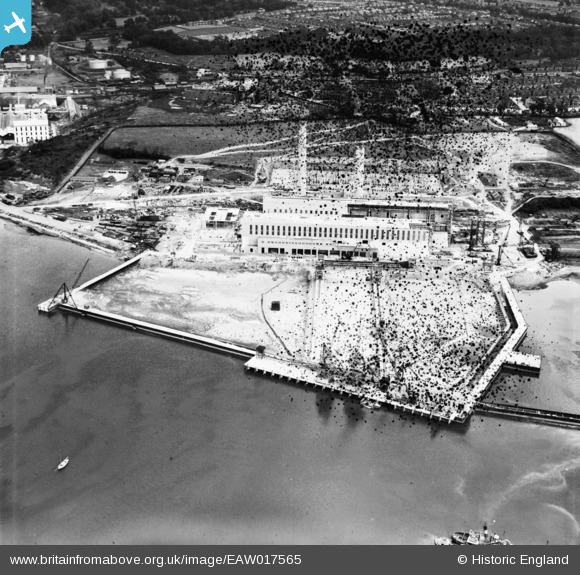
EAW017565 ENGLAND (1948). Cliff Quay Power Station under construction, Ipswich, 1948. This image has been produced from a damaged negative.
© Copyright OpenStreetMap contributors and licensed by the OpenStreetMap Foundation. 2026. Cartography is licensed as CC BY-SA.
Nearby Images (48)
EAW017565

EAW027825

EAW027822

EAW033200

EAW027823

EAW008082

EAW024338

EAW027812

EAW017578

EAW008078

EAW024335

EAW033198

EAW008088

EAW020668

EAW008089

EAW033193

EAW024326

EAW002326

EAW033194

EAW033196

EAW020671

EAW020689

EAW017572

EAW001989

EAW002323

EAW001983

EAW033191

EAW020670

EAW017564

EAW008084

EAW024334

EAW001984

EAW008083

EAW002324

EAW027814

EAW020667

EAW002321

EAW024322

EAW001990

EAW012452

EAW020676

EAW020681

EAW002318

EAW024319

EAW020687

EAW024329

EAW012453

EAW024321

Details
| Title | [EAW017565] Cliff Quay Power Station under construction, Ipswich, 1948. This image has been produced from a damaged negative. |
| Reference | EAW017565 |
| Date | 23-July-1948 |
| Link | |
| Place name | IPSWICH |
| Parish | |
| District | |
| Country | ENGLAND |
| Easting / Northing | 616908, 242023 |
| Longitude / Latitude | 1.162664368588, 52.033696701073 |
| National Grid Reference | TM169420 |
Pins
Be the first to add a comment to this image!